(WCS – R03/2025)
March 13, 2025 – Unseasonably warm temperatures and up to 25 mm of rain will lead to high water levels across the watershed and the possibility of flooding along North Gower’s Stevens Creek and Taylor Drain beginning March 16.
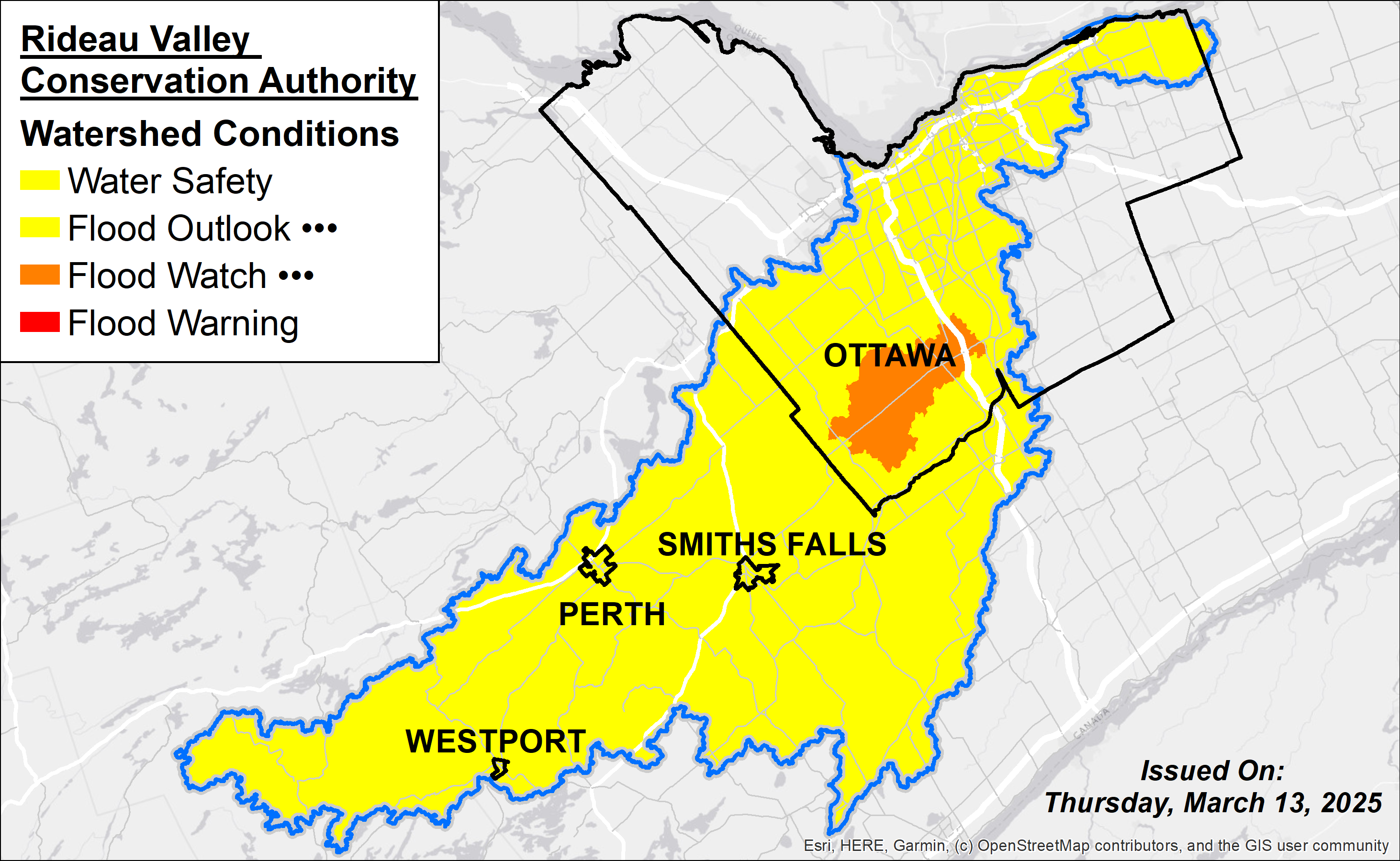
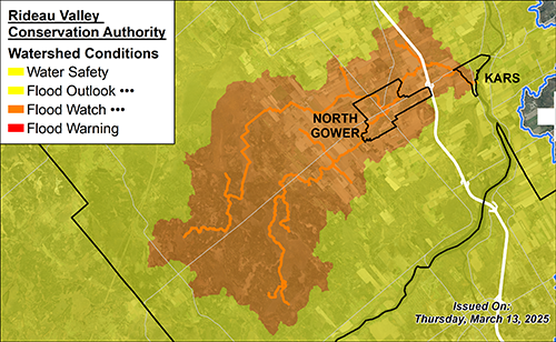
The forecast remains variable and although no significant flooding is expected at this time, localized flooding is possible. Also, rapidly melting snow could impact all waterbodies across the Rideau Valley, leading to flooding in low-lying areas as well as ditches and stormwater features. A Flood Watch is in effect for both Stevens Creek and Taylor Drain in North Gower. A Flood Outlook Statement is in effect for the rest of the watershed. A general Water Safety Statement remains in effect, advising caution around all waterbodies.
Residents in the City of Ottawa can check flood risks in their area using our Neighbourhood Flood Maps. If your property is within the rest of the RVCA watershed, use our Map your property tool to assess potential flooding impacts. Current water levels and stream flow with flood onset limits can also be consulted on our Interactive Map.
This Flood Watch and Flood Outlook statement is in effect until March 18, 2025 at 11:59 pm or until an update has been issued.
MORE DETAILS:
Weather Forecast: Environment and Climate Change Canada is forecasting a significant warming event and widespread rainfall that will impact the Rideau Valley Watershed. Daytime temperatures are expected to rise above freezing, reaching highs of 10-18°C from March 14 to March 17, followed by a brief cooldown period on March 18. Rainfall amounts of 15 to 25 mm are possible for March 16, however forecast confidence is low to moderate regarding the location of the heaviest rainfall, as isolated thunderstorms may produce locally higher amounts.
Environmental Conditions: Water levels and flows across the Rideau Valley Watershed are generally at or below seasonal levels. With the recent freeze and thaw cycles, the snowpack density has increased significantly and will be primed for a strong melt by this weekend. Snow-water content remains at seasonal normal levels across the watershed.
Risks: The entire watershed is under a flood outlook, with localized areas under a flood watch, with the following risks present:
- The warmer temperatures and rainfall may trigger an accelerated melt, leading to rapid increases in water levels and flows. Thunderstorm activity may produce locally higher amounts of rainfall, which could increase flood risk in some localized areas.
- Frozen ground conditions and densified snow may limit water absorption, leading to ponding in low-lying areas, ditches, and stormwater systems. Smaller tributaries may respond quickly to increased precipitation and runoff.
- Rising water levels and faster flows will continue to weaken ice cover, leading to hazardous conditions near lakes, rivers, and streams (slippery or unstable banks). Ice may become unsafe for recreational activities, and shifting ice could pose risks to infrastructure.
- With water levels and flows in an elevated state, reduced capacity will remain to absorb further melt or rainfall over the short-term.
- The ice cover is expected to continue weakening and breaking up, creating a risk of ice jamming.
Location-Specific Considerations: All water levels and flows across the Rideau Valley Watershed are expected to increase with possible flooding in low-lying areas, including ditches and stormwater features.
Rideau River & Major Subwatersheds (Flood Outlook): Water levels and flows are expected to rise rapidly on March 16, reaching peak levels between March 18 – March 20. The likelihood of significant flooding impacts is not anticipated at this time, however, localized areas may experience flooding associated with risks listed above.
North Gower – Stevens Creek & Taylor Drain (Flood Watch): Due to the anticipated rapid melt and possible localized rainfall intensity, a flood watch is being issued for the North Gower region. Water levels and flows in Stevens Creek and the Taylor Drain are expected to rise rapidly on March 16 – March 17, and may possibly approach flooding onset levels.
Action & Safety Recommendations: Residents in flood-prone areas are advised to closely monitor water levels and flows and take the necessary precautions to protect their property, such as:
- Ensuring sump pumps are clear, in good working condition, and have a backwater valve.
- Keeping a portable backup generator and pump easily accessible.
- Ensuring downspouts are clear and directing water at least 3 m away from the dwelling.
- Securing items that might float away as flows increase.
- Removing valuable items from basements or lower floors that could be subject to flooding.
- Keeping emergency phone numbers handy.
- Familiarizing yourself with your municipality’s Emergency Preparedness Plan.
Residents are reminded that a Water Safety Statement is in effect until April 15th and advised to exercise caution when near rivers, streams, and other waterbodies due to the risks described above. Parents should inform their children of these dangers and provide appropriate supervision.
RVCA monitors water levels and weather forecasts as part of its Flood Forecasting and Warning Program. Updates will be provided as conditions change.
For more information, contact:
Isabelle Maltais
Director, Watershed Science & Engineering
1-800-267-3504 ext. 1165
RVCA Watershed Conditions Statements:
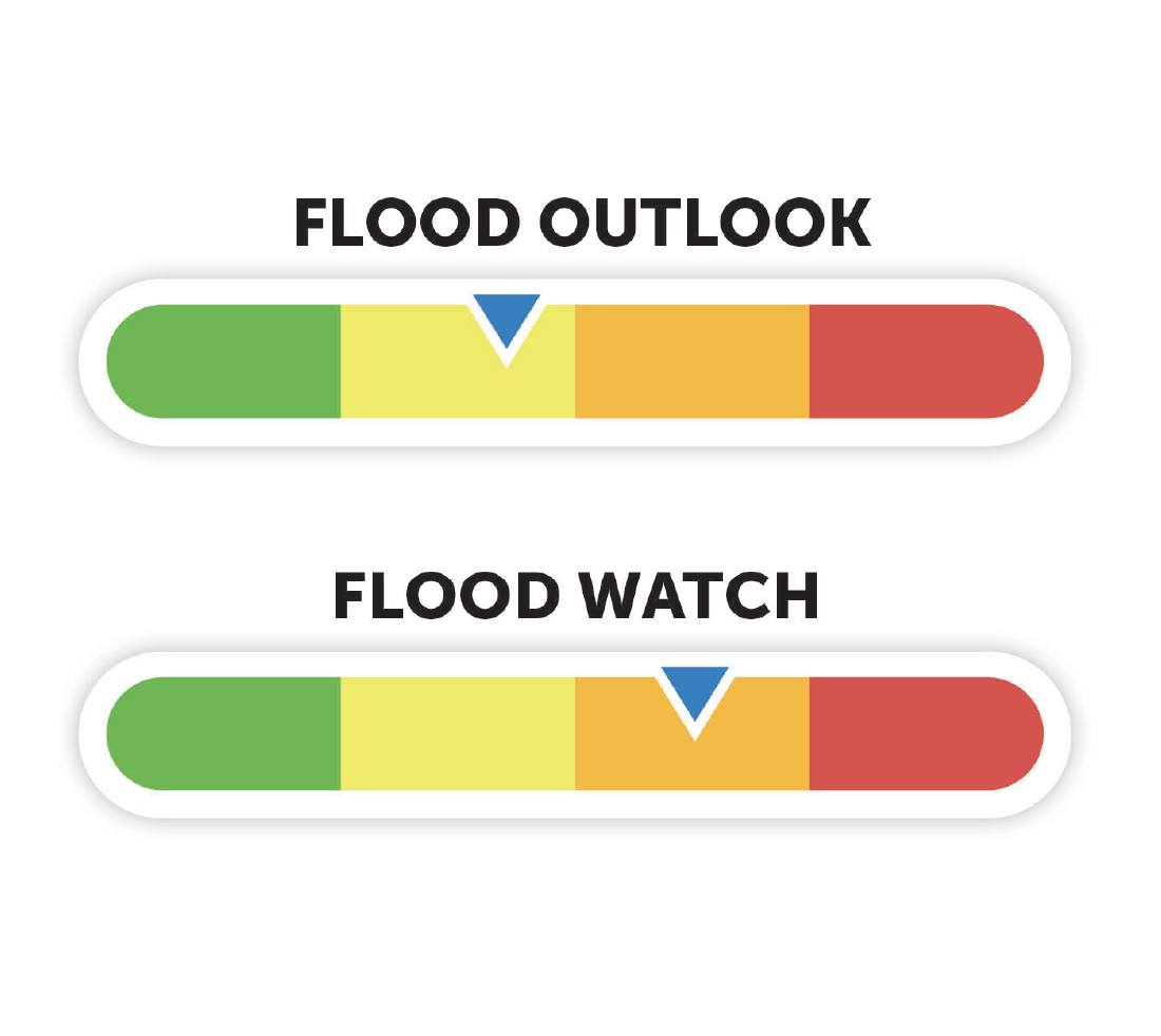
Water Safety – High flows, unstable banks, melting ice or other factors that could be dangerous for recreational users such as anglers, canoeists, hikers, children, pets, etc. Flooding is not expected.
Flood Outlook – Early notice of the potential for flooding based on weather forecasts, calling for heavy rain, snow melt, high winds or other conditions that could lead to high runoff, cause ice jams and/or lakeshore flooding or erosion.
Flood Warning – Flooding is imminent or already occurring in specific watercourses or municipalities.
Flood Watch – Flooding is possible in specific watercourses or municipalities. Municipalities, emergency services and individuals in flood prone areas should prepare.