RVCA (1140)
Children categories
Department (68)
Main Office Phone Numbers : 613-692-3571 / 1-800-267-3504
Staff Directory
Fresh water is a natural resource critical to the economic and environmental well being of all residents of the Rideau Valley. Periods of dry, hot weather and low water levels were relatively uncommon — happening every decade or so. But, with changing weather patterns, low water levels may occur more often, especially with the increasing demand for water.
The Government of Ontario has developed the Ontario Low Water Response Plan, which ensures that the province is prepared for low water conditions in the future. The response plan helps co-ordinate and support local response in the event of drought. The local teams are established in areas experiencing low water conditions so that the local community can carry out actions to reduce and better manage water use.
The Rideau Valley Water Response Team, co-ordinated by RVCA, is made up of representatives of water users: member municipalities, farmers, businesses, recreation and others. The Low Water Response Team communicates when necessary to review stream flow information and weather forecasts. Based on the information, the committee may declare a low water condition for the watershed.
Feeling the impact of a drought in the Rideau Valley? Help us track and understand local concerns.
Email us using the Subject: Drought Impacts.
Include the following details in your email:
- Your name
- Your address
- Your phone number and
- comments how the drought is impacting you.
Low water affects:
- municipal sources
- private wells
- lakes, rivers, ponds and all the residents in those waters
- agriculture — irrigation, watering livestock
- fire fighting
- business and industrial uses
- recreation (boating, fishing, swimming)
- personal use — drinking, washing, laundry, etc.
Members of the Rideau Watershed Low Water Response Team
- Ontario Ministry of Agriculture, Food and Rural Affairs
- Ontario Ministry of Natural Resources and Forests
- Ontario Ministry of the Environment and Climate Change
- Parks Canada - Rideau Canal
- Rideau Valley Conservation Authority
- Watershed municipalities
Our low flow index has four stages:
- Normal
- No low flow or drought conditions exist.
- Minor
- This category reflects concern.
80% to 60% of long-term average precipitation for 540 day and/or 90 day precipitation totals and/or 7-day average streamflows less than the 5 year return period low flow. - Moderate
- This category suggests a potentially serious problem is pending.
60% to 40% of long-term average precipitation for 540, 90 and/or 30 day precipitation totals and/or 7-day average streamflows less than the 10 year return period low flow. - Severe
- This category indicates a failure of the water supply to meet demand.
Less than 40% of long-term average precipitation for 540, 90 and/or 30 day precipitation totals and/or 7-day average streamflows less than the 10 year return period low flow.
Click here for the RVCA's Watershed Conditions Statements.
Links
Tips on How To Manage your Water Well in Times of Water Shortage
Tips — How to Conserve Water
- Filling wells with surface water, or potable water is not recommended. Installing a holding tank that links to a household system, and filling that with potable water is a better option.
- Removing water from streams and lakes for watering lawns or gardens may cause problems for other users.
In the yard
- Brown grass is only dormant, not dead. Grass only needs 25 mm of water each week to do well, any more can weaken the roots.
- 20 L (5 gal) of water once a week will help trees survive dry conditions.
- Don't water lawns and gardens when a municipal water shortage warning is in effect.
- If you must water, only water gardens and lawns once a week, no more than one inch in total, including rain.
- Avoid watering on windy days and water your lawn and plants in the morning — evaporation occurs at a slower rate than if you watered in the hot sun.
- Cut grass less frequently and cut grass higher as it reduces evaporation and increases moisture.
- Collect and use rainwater for your lawn and gardens — it's free and better for your plants than municipally supplied water or well water. Consider buying a rain barrel.
- Plant drought resistant plants — convert your lawns to low-care perennials.
Your car
- Don't wash your car when a municipal water shortage warning is in effect.
- Use commercial car washes that recycle their water.
- If you do wash your car, do it on the lawn. Use a bucket of soapy water and the bare minimum to rinse it off.
In the kitchen
- Rinse fruits and vegetables by putting a little water in the sink or a bowl instead of running water.
- When hand washing dishes, plug the drain and do them all at once.
- Run the dishwasher with full loads only.
- Defrost frozen foods in the refrigerator or the microwave, not under running water.
- For cold water to drink, keep a jug in the fridge instead of running the tap.
In the bathroom
- Install a low-flush toilet or install a toilet dam in your toilet tank to reduce water use.
- Keep showers to five minutes or less.
- Consider buying a water efficient showerhead.
- If you must take a bath, fill the tub with only the amount of water really needed to clean yourself (1/4 full).
- When cleaning your teeth, don’t keep the tap running, use a glass to rinse. Rinsing a toothbrush under a tap wastes about 4,000 litres of water a year.
- Replace all leaky tap washers, they can waste more than 400 litres of water a day. Repair all leaks in pipes and toilets as well.
Laundry
- Wash clothes only when you have a full load.
Feeling the impact of a drought in the Rideau Valley? Any individuals or businesses experiencing problems due to low water are encouraged to contact the Water Response Team to help us track and understand local conditions.
Email us using the Subject: Drought Impacts.
Include the following details in your email:
- Your name
- Your address
- Your phone number and
- comments how the drought is impacting you.
PLANS
RVCA 2020 Flood Contingency Plan
FACTSHEETS
What Should You Do If You Are At Risk Of Flooding?
Cleaning Up After the Flood Proper Handling and Disposal of Sandbags
LINKS
City of Ottawa: Flood Information
Environment Canada Flood Forecasting Centres Across Canada
Public Safety Canada — Floods in Canada
Government of Canada Self-help Brochure: Floods — What to do Before and After
Conservation Ontario — Flood Facts Fact Sheet
VIDEOS
A New Type of River Management is Coming!
Early Spring Water Safety (Source: Quinte Conservation)
Water levels that were already high from rain on Sunday and Monday are expected to increase again if rain forecast for Thursday and Friday falls on the Rideau River watershed.
About 12 millimetres (mm) of rain fell overnight and as much as 40 mm more is expected. This could cause flows in the Rideau below Mooneys Bay to increase to about 320 cubic metres per second. While not an issue in the lower sections of the system, such flows typically mean flooding of low-lying areas on the Long Reach, the section of the river between Manotick and Burritts Rapids, with the access roads to the river side communities at risk.
High flows on the Tay River in Perth continue with most of the flow directed through the Little Tay which has caused flooding in Stewart Park. The construction site at Haggart Island Dam is being monitored closely.
The forecast rain can be expected to cause increased flows in the smaller streams such as Steven Creek. Residents in North Gower can once again expect to see the banks close to full through to next week.
Residents are advised to stay away from rivers as the forecasted weather may rapidly increase river flows, and cause slippery river banks. Parents are encouraged to explain these dangers to their children.
For water level and flow information in the Rideau system as well as the Ottawa River, visit the RVCA Streamflows and Water Levels webpage at: https://www.rvca.ca/watershed-monitoring-reporting/monitoring/surface-water-quantitiy
For more information about conditions on the Ottawa River, check the webpage of the Ottawa River Regulation Planning Board at http://ottawariver.ca/river-levels-flows.php#river-levels-flows-7-days .
(WCS - 41/2017)

MAY 1, Ottawa River – Constance Bay Area — Further to the press release issued by the Ottawa River Planning Board, the Mississippi Valley Conservation Authority is issuing a Flood Outlook for the Lac Deschene (Constance Bay, Britannia Bay) area of the Ottawa River watershed.
Levels and flows along the Ottawa River have started to increase with the onset of the spring freshet period. Based on the current snowpack and the weather forecast, levels and flows from Arnprior to Deschenes Rapids are expected to remain within the normal range of fluctuations associated with this time of year; however the normal range may be slightly exceeded. Model outputs currently indicate that levels are expected to increase of 50 to 60 cm over the next week and peak on or about May 7th, 2018. Given the size of the Ottawa River basin and forecasted rain over the next week, these predictions could change quickly and significantly.
Levels and flows along the Ottawa River have started to increase with the onset of the spring freshet period. Based on the current snowpack and the weather forecast, levels and flows are expected to remain within the normal range of fluctuations associated with this period of the year.
Residents are strongly urged to remind children of the dangers of hypothermia from cold water and playing near fast flowing rivers and creeks.
Residents in low lying areas, historically susceptible to flooding, should take the necessary precautions to protect their property, such as:
• Ensuring sump pumps are clear and in good working condition
• Removing or securing items that might float away as flows increase
This Watershed Conditions Statement is valid through May 7, 2018. Additional statements will be issued when or if conditions are expected to change significantly from this outlook.
Daily water levels and flows are available on the MVCA website at http://mvc.on.ca/water-levels/
The Mississippi Valley Conservation Authority flood forecasting and warning program monitors weather conditions, snowpack water content, estimates expected river flows and water levels and issues flood advisories or warnings as required. MVCA provides early warning and continuous monitoring to municipal and provincial emergency response personnel through a flood event.
Flood Outlook - Ottawa River (Cumberland, Britannia Bay, Constance Bay) Ottawa River Levels Increase
Written by Super User
May 4, 2018 – Water levels are expected to increase through the weekend on the Ottawa River.
As snowmelt runoff from the upper reaches of the Ottawa River watershed continues to work through the system, levels on the river in the Ottawa area are expected to rise. A weather system presently passing through the region will combine with the snowmelt to raise levels in low-lying shoreline areas that are typically flooded during spring freshet. More extensive flooding is not expected at this time.
Weather forecasts are presently indicating that next week will bring sun and warmer temperatures which will help cause levels to decline toward normal early summer levels.
Note that streambanks are slippery along the river, water is fast moving and still very cold. Children should be informed about the hazards and kept away from all watercourses as levels fluctuate with the spring weather.
This message in effect until May 7.
Ottawa River Regulation Planning Board http://ottawariver.ca/river-levels-flows.php#river-levels-flows-7-days for more information.
Managing flood risks in the Rideau Valley
Conservation authorities have a broad mandate to protect their watersheds, which can include everything from tree planting to regulating development in the floodplain. Not surprisingly, many residents have questions about the role of conservation authorities in their lives, especially when it comes to floods.
A flood is coming: What should you do?
If you live in a flood-prone area, the best thing you can do to keep your family and property safe is to make a plan and be prepared to follow it.
Each flood situation is unique, and your emergency plan should account for that – and be ready well in advance.
1. Know the warning system
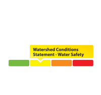
The RVCA issues water conditions statements to inform residents, municipalities and other stakeholders of changing water levels across the watershed.


Click on a gauge for a larger image
GREEN: A green gauge means conditions are normal.
YELLOW: A yellow gauge can mean two things:
- A yellow Water Safety Statement means rivers could have high flows, unsafe banks, melting ice or other factors that could be dangerous. However, flooding is not expected.
- A yellow Flood Outlook Statement is an early notice of the potential for flooding based on weather forecasts calling for heavy rain, snow melt, high wind or other conditions that could lead to high runoff, cause ice jams, lakeshore flooding or erosion.
ORANGE: An orange Flood Watch means flooding is possible in specific watercourses or municipalities. Municipalities, emergency services and individual landowners in flood-prone areas should prepare.
RED: A red Flood Warning means flooding is imminent or already occurring in specific watercourses or municipalities.
2. Be prepared
- The first step to flood preparedness is knowing your risk level. Call an RVCA Resource Specialist to learn more about your property before flooding occurs.
- Subscribe to RVCA’s flood messages for regular updates and advanced warning of an impending flood. You can also stay informed through the RVCA website or our Facebook and Twitter pages.
- Learn about your municipality’s emergency plan: evacuation routes and locations for emergency shelters, as well as their sandbag program if they have one.
- Plan and practice an evacuation route with your family.
- Pack an emergency kit that can be accessed easily and carried quickly in case of evacuation; include any necessary medication, blankets, extra clothing and flashlights.
- Install a battery powered sump pump that can work in a blackout.
Learn more from Environment Canada's detailed flood preparation guide.
More...
Know the warning system
The RVCA issues water conditions statements to inform residents, municipalities and other stakeholders of changing water levels across the watershed.
A green gauge means conditions are normal.
A yellow Water Safety Statement means rivers could have high flows, unsafe banks, melting ice or other factors that could be dangerous. However, flooding is not expected.
A yellow Flood Outlook Statement is an early notice of the potential for flooding based on weather forecasts calling for heavy rain, snow melt, high wind or other conditions that could lead to high runoff, cause ice jams, lakeshore flooding or erosion.
An orange Flood Watch means flooding is possible in specific watercourses or municipalities. Municipalities, emergency services and individual landowners in flood-prone areas should prepare.
A red Flood Warning means flooding is imminent or already occurring in specific watercourses or municipalities.
Click here for the RVCA's Watershed Conditions Statements. Click here for RVCA real-time flows and water levels.
For water levels and flows on the Ottawa River visit the Ottawa River Regulation Planning Board
Our low water index has four stages:The RVCA issues water conditions statements to inform residents, municipalities and other stakeholders of changing water levels across the watershed.

A green gauge means conditions are normal. No low flow or drought conditions exist.

This category reflects concern.
80% to 60% of long-term average precipitation for 540 day and/or 90 day precipitation totals and/or 7-day average streamflows less than the 5 year return period low flow.

This category suggests a potentially serious problem is pending.
60% to 40% of long-term average precipitation for 540, 90 and/or 30 day precipitation totals and/or 7-day average streamflows less than the 10 year return period low flow.

This category indicates a failure of the water supply to meet demand.
Less than 40% of long-term average precipitation for 540, 90 and/or 30 day precipitation totals and/or 7-day average streamflows less than the 10 year return period low flow.
Click here for the RVCA's Watershed Conditions Statements.
-
Watershed Conditions Statement: Forecasted Precipitation to Increase Water Levels Across Rideau Valley Watershed
(WCS – R08/2024)
August 08, 2024 – The Rideau Valley Conservation Authority is issuing a WATER SAFETY message for the entire Rideau Valley Watershed.A low-pressure system associated with remnants of Tropical Storm Debby is expected to produce heavy rainfall throughout the region. Local estimates of 50 to 100 mm of rainfall are possible beginning Thursday evening and continuing into Friday. Despite above normal precipitation over the last month, stream flows have generally stabilized at normal seasonal levels.
Although riverine flooding is not anticipated at this time, all water levels and flows across the Rideau Valley Watershed are expected to increase. Depending on the location and rainfall intensity, localized flooding in low-lying areas, including ditches and stormwater features, may be possible. Flows on the Rideau River are not expected to increase significantly.
It is advised that residents adjacent to smaller tributaries and streams take precautionary measures to protect their property, including:
- Ensuring sump pumps are clear, in good working condition and have a backwater valve
- Ensuring easy access to a portable backup generator and pump
- Ensuring downspouts are clear and the outlet is at least 3 metres from the dwelling
- Securing items that might float away as flows increase
Until the water levels and flows recede, the RVCA advises the public to exercise extreme caution around ALL WATERBODIES and remind children about the dangers of playing near open water.
This watershed conditions statement is in effect until Friday, August 16, 2024 at 5 PM or until an update has been issued.
-end-
Contact: Brian Stratton, RVCA Manager Engineering Services
Rideau Valley Conservation Authority
613-692-6804, 1-800-267-3504 ext. 1141
www.rvca.ca/watershed-conditions"Rideau Valley Conservation Authority is a partnership of municipalities within the Rideau Valley watershed
created under the Conservation Authorities Act to deliver a range of programs in watershed management and
natural resource conservation."
RVCA Watershed Conditions Statements:
- Water Safety – High flows, unstable banks, melting ice or other factors that could be dangerous for recreational users such as anglers, canoeists, hikers, children, pets, etc. Flooding is not expected.
- Flood Outlook – Early notice of the potential for flooding based on weather forecasts, calling for heavy rain, snow melt, high winds or other conditions that could lead to high runoff, cause ice jams and/or lakeshore flooding or erosion.
- Flood Watch – Flooding is possible in specific watercourses or municipalities. Municipalities, emergency services and individuals in flood prone areas should prepare.
- Flood Warning – Flooding is imminent or already occurring in specific watercourses or municipalities.
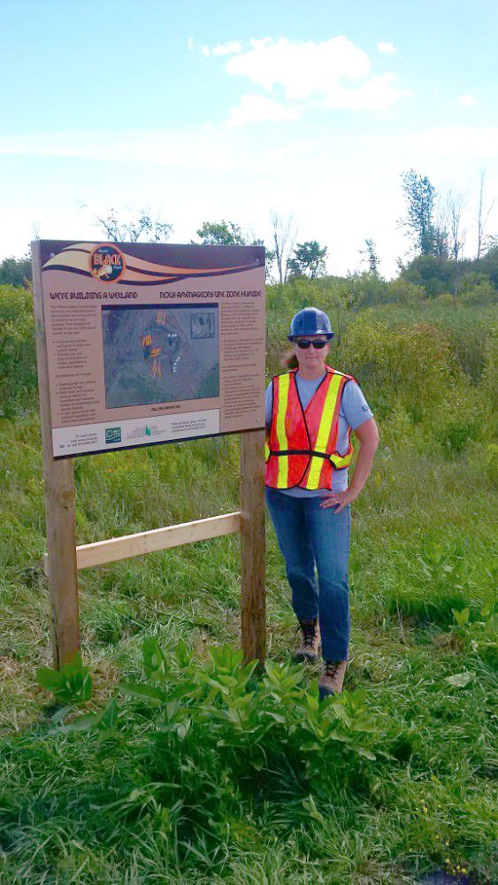
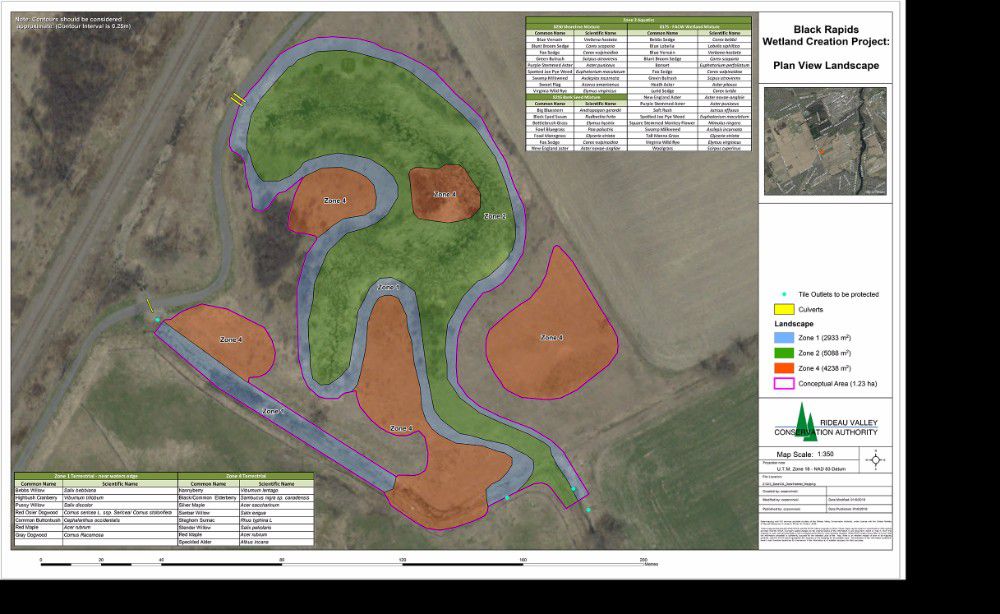
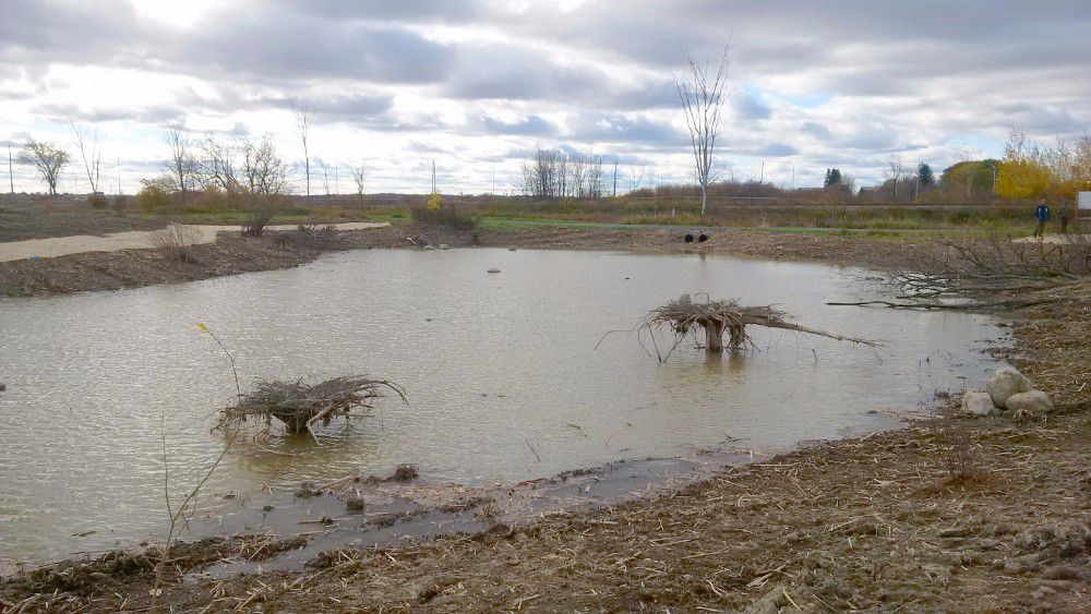
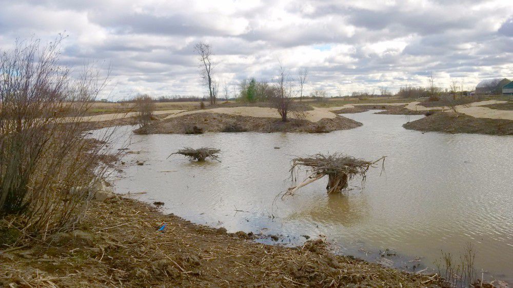
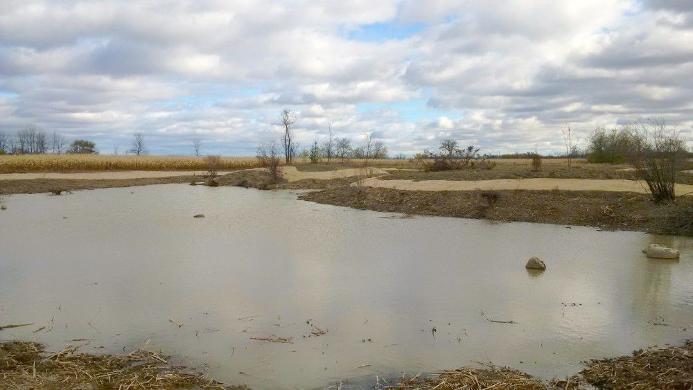
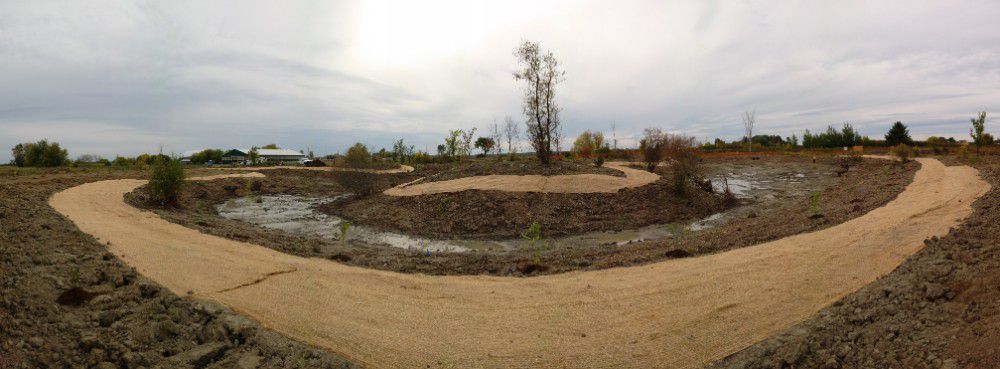
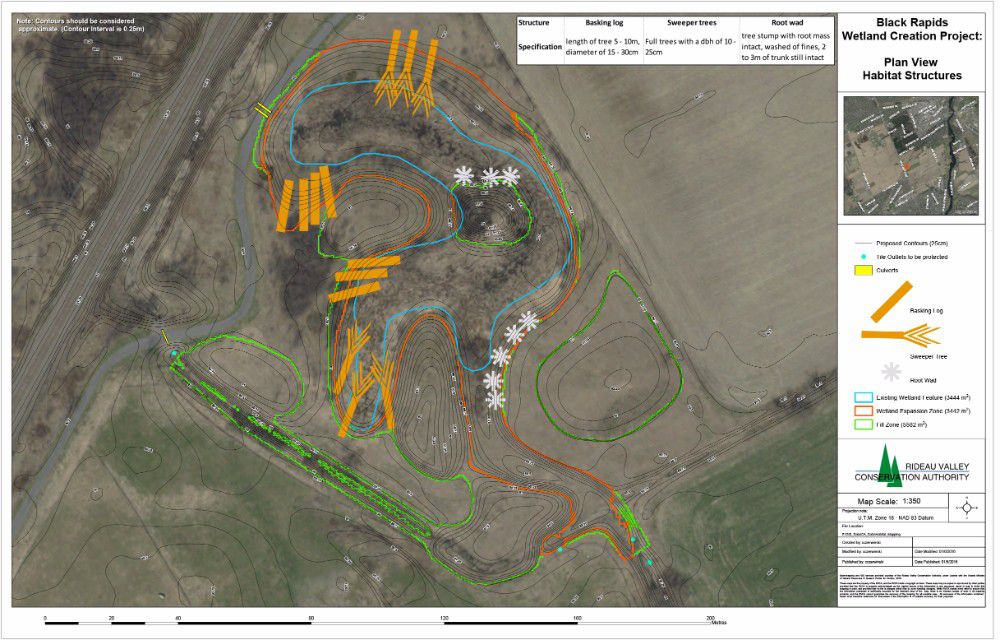
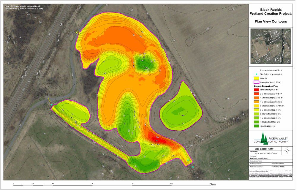
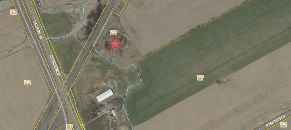
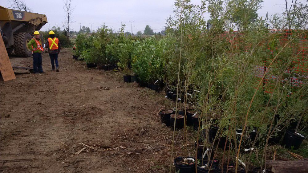
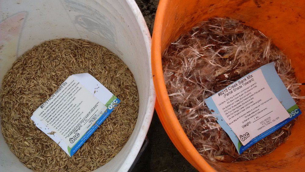
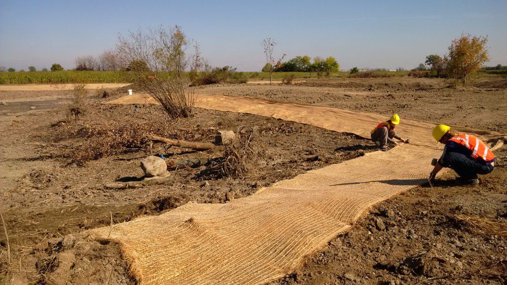
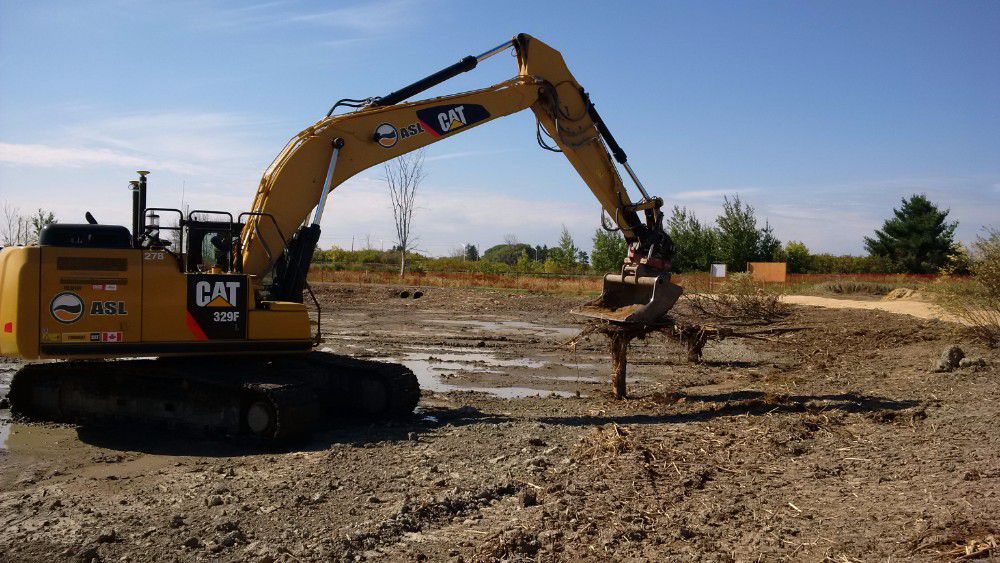
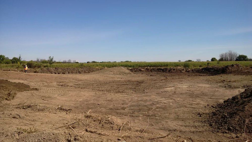
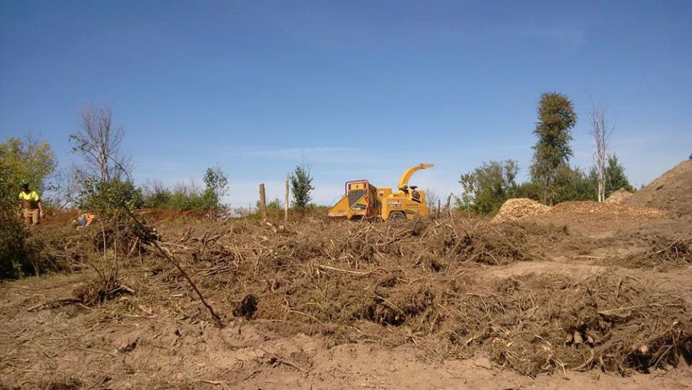
The Rideau Valley Conservation Authority in collaboration with NCC and the Great Lakes Guardian Community Fund have designed and enlarged the Black Creek wetland located in Ottawa’s Greenbelt. This enhanced wetland improves water quality, increases biodiversity and provides important wetland habitat in the headwaters of Black Rapids Creek.
The wetland has doubled in size from 3,444 square metres to almost 7,000 square metres. A tributary that had previously bypassed the wetland now flows into it providing a larger aquatic feature that supports amphibian breeding, fish habitat, bird foraging, and acts as a water supply for wildlife. The wetland now boasts a variety of side slopes, woody debris (i.e. root wads, basking logs and sweeper trees) and re-planting of native trees, shrubs and wetland vegetation. The project was completed in September 2016.
Staff returned to monitor the wetland in 2017 and 2019, and will return again in 2021.
BLOG: Restored Black Rapids wetland keeping Rideau River clean
Benefits of the project:
- Improves water quality for Black Rapids Creek and the Rideau River
- Increases biodiversity of aquatic/terrestrial plants and fish and wildlife
- Provides winter and summer refuge areas for wetland wildlife, including nursery area for waterfowl and area for shorebirds to feed
- Includes functional spawning, nursery, rearing and food supply habitat for fish allowing for wetland and
- Presents a unique habitat feature along the National Capital Commission Greenbelt Pathway allowing for wetland and habitat restoration activities
Construction Plans: