


RVCA (1140)
Children categories
Department (68)
Main Office Phone Numbers : 613-692-3571 / 1-800-267-3504
Staff Directory
Project Status: Active
Web update: May 5, 2022
The Rideau Valley Conservation Authority (RVCA) has completed a hazard mapping study for Stevens Creek from Malakoff Road to the Rideau River in the City of Ottawa.
These maps have been traditionally known as “floodplain mapping” or “regulation mapping” and they show areas that are prone to natural hazards such as flooding, erosion and natural environment features such as wetlands.
When completed, the mapping will be used by the City of Ottawa when updating their Official Plan and Zoning Schedules and in the review of development applications under the Planning Act. RVCA will also use the mapping to guide the review of development applications submitted under the Development, Interference with Wetlands and Alterations to Shorelines and Watercourses Regulation.
Public consultation on the draft hazard mapping study for Stevens Creek from Malakoff Road to the Rideau River will continue until April 29, 2022. Virtual public consultation began late November 2021. Affected landowners were notified by mail and staff have been responding to inquiries by telephone calls, e-mail, virtual meetings, small group in-person meetings and site visits. In some cases the draft mapping has been refined based on site-specific information.
With the recent easing of provincial COVID-19 restrictions, the RVCA is now able to host an in-person presentation and question and answer session to provide an additional opportunity for public consultation.
Thursday, April 21, 2022
Alfred Taylor Recreation Centre
2300 Community Way, North Gower
Doors Open at 6:00 p.m.
Presentation begins at 6:15 p.m.
Question & Answer Period to follow
Anyone unable to attend can contact an RVCA Resource at 613-692-3571, toll-free at 1-800-267-3504 or by email at .
This study is just one of several ongoing hazard mapping studies taking place in the watershed. For a complete list on ongoing work, click here.
Draft Maps
Draft Maps - Updated: April 2022
OPTION 1: Interactive Map - Click here to view the interactive map full screen
The interactive map allows you to zoom in to a specific property and get very specific digital informaiton. Need help? Have questions? Call a Resource Specialist at 613-692-3571 or 1-800-267-3504 ext. 1132 or 1193 or email us at .
OPTION 2: PDF Maps
If you prefer more traditional mapping, try our PDF maps. Need help? Have questions? Call a Resource Specialist at 613-692-3571 or 1-800-267-3504 ext. 1132 or 1193 or email us at .
|
Index Map:
|

Public Consultation
Public consultation on the draft hazard mapping study for Stevens Creek from Malakoff Road to the Rideau River will continue until April 29, 2022. With the recent easing of provincial COVID-19 restrictions, the RVCA is now able to host an in-person presentation and question and answer session to provide an additional opportunity for public consultation.
Thursday, April 21, 2022
Alfred Taylor Recreation Centre
2300 Community Way, North Gower
Doors Open at 6:00 p.m.
Presentation begins at 6:15 p.m.
Question & Answer Period to follow
Anyone unable to attend can contact an RVCA Resource at 613-692-3571, toll-free at 1-800-267-3504 or by email at .
Questions? Comments? Please contact an RVCA Resource Specialist:
Phone: 613-692-3571 or 1-800-267-3504 ext. 1132 or 1193
Email: or complete an online property inquiry form
For those unable to participate in the consultation process, comments can be sent to Tyler Bauman, RVCA Water Resources Engineer (Flood Management) at .
Resources
- November 2021 Landowner Factsheet: Stevens Creek Hazard Mapping
- March 2022 Landowner Factshee: Stevens Creek Hazard Mapping
- Fiche descriptive, Nov. 2021: Étude cartographique des risques liés au ruisseau Steven
- Fiche descriptive, Mars 2022 : Étude cartographique des risques liés au ruisseau Steven
- Video: Hazard Mapping for Floods: What it is and why we do it
RVCA seeks public input for new hazard maps in North Gower
RVCA seeks public input for new hazard maps in Beckwith Township
Project Status: Complete
The Rideau Valley Conservation Authority (RVCA) has completed a hazard mapping study for the Jock River between Ashton Station Road and approximately the south limit of the community of Franktown. This section of the Jock River is being hazard mapped for the first time; however, both the Goodwood Marsh and Franktown Swamp (both Provincially Significant Wetlands and both within the study limits) have been regulated since 2006.
These maps have been traditionally known as “floodplain mapping” or “regulation mapping” and they show areas that are prone to natural hazards such as flooding, erosion and natural environment features such as wetlands.
When completed, the mapping will be used by Beckwith Township when updating their Official Plan and Zoning Schedules and in the review of development applications under the Planning Act. RVCA will also use the mapping to guide the review of development applications submitted under the Development, Interference with Wetlands and Alterations to Shorelines and Watercourses Regulation.
Due to Covid 19, we are not holding an in-person public open house. Instead, we invite you to contact an RVCA Resource Specialists at 613-692-3571 (toll-free 1-800-267-3504) extension 1193 or 1132 or . If you prefer, we can book individual or small group meetings on-line or in person to discuss local impacts and concerns. This is also an opportunity to learn how flood risks and slope stability hazards may affect shoreline management and/or development in Beckwith Township. Authority staff welcome historical records of past flood events, slope failure, erosion, news clippings, photographs and even anecdotal stories to help confirm the reasonableness of calculations and resulting hazard mapping.
This study is just one of several ongoing hazard mapping studies taking place in the watershed. For a complete list on ongoing work, click here.
Upper Jock Report
Report: Jock River Flood Risk Mapping from Richmond Road to Ashton Station Road, July 16, 2021
2021 Draft Maps
2021 Draft Maps
OPTION 1: Interactive Map - Click here to view the interactive map full screen
The interactive map allows you to zoom in to a specific property and get very specific digital informaiton. Need help? Have questions? Call a Resource Specialist at 613-692-3571 or 1-800-267-3504 ext. 1132 or 1193 or email us at .
OPTION 2: PDF Maps
If you prefer more traditional mapping, try our PDF maps. Need help? Have questions? Call a Resource Specialist at 613-692-3571 or 1-800-267-3504 ext. 1132 or 1193 or email us at .
|
Index Map:
|

Public Consultation
Members of the public are invited to review the draft regulation and hazard maps during the public consultation period between November 15 and December 22, 2021.
Questions? Comments? Please contact an RVCA Resource Specialist:
Phone: 613-692-3571 or 1-800-267-3504 ext. 1132 or 1193
Email: or complete an online property inquiry form
For those unable to participate in the consultation process, comments can be sent to Ferdous Ahmed, RVCA Senior Water Resources Engineer at .
Resources
- Upper Jock River Hazard Mapping Factsheet
- Video: Hazard Mapping for Floods: What it is and why we do it
September-October 2021 Around the Rideau Newsletter now available!

Green Acres tree planting program hits 2 million milestone
Low Water Status Returned to “Normal” in Rideau Valley Watershed
More...
Plan ahead to avoid fall colour crowds at Foley Mountain
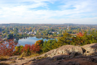

Foley Mountain is spectacular in fall, but visitors should plan ahead to avoid crowds.
During peak season (end of September to mid-October), staff are on-site every day to assist visitors with purchasing passes, managing parking, and helping things run smoothly. Visitors may be asked to park in auxiliary parking at the Interpretive Centre and other areas away from Spy Rock to ease congestion.
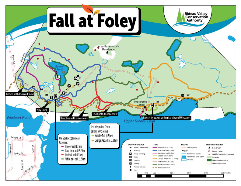
See the Foley Fall Colours map below for alternative parking and trail directions (click map to download a PDF):
Tips For An Unforgettable Foley Mountain Visit:
1. Avoid peak times
Thanksgiving weekend is the busiest time of the year at Foley Mountain, with weekends on either side of the holiday also attracting large crowds. Avoid line-ups and crowds by visiting at off-peak times, such as early in the morning or in the evening, and mid-week instead of weekends.
2. Plan ahead for parking
The Spy Rock parking lot fills up quickly, especially on weekends. Come prepared with coins instead of credit cards for the pay machine, or use www.PayByPhone.com to reduce long line-ups (location code 5204).
You may be asked to park in auxiliary parking areas at the Interpretive Centre, group camping site or at designated spots along the main road to reduce congestion. Be prepared to hike a short distance back to Spy Rock, either along the road or using one of the park’s other trails.
3. Share Spy Rock
As one of the most popular lookouts at Foley Mountain, Spy Rock can be a busy spot during fall colours. Please be considerate of other visitors and resist the temptation to linger a long time when others are waiting. Take your time to enjoy the view and take some photos, and then let others have a chance!
4. Explore the whole park
There’s more to Foley Mountain than just Spy Rock: explore it! Foley Mountain offers 10 kilometres of trails ranging from our accessible 400-metre Mobility Trail (including a Story Trail for the youngest visitors) to more rugged treks across the top of the mountain.
Check out these three alternative fall hikes: https://www.rvca.ca/view-all-blog-posts/beyond-spy-rock-three-fabulous-fall-hikes-at-foley-mountain
5. Stay informed
For maps and general park information visit www.rvca.ca/conservation-areas/fee-required/foley-mountain-ca. For the most up-to-date information follow our Facebook pages at @FoleyMountain and @RideauValleyConservationAuthority or follow RVCA on Twitter at @RideauValleyCA.