RVCA (1140)
Children categories
Department (68)
Main Office Phone Numbers : 613-692-3571 / 1-800-267-3504
Staff Directory
Station Metadata [SNOW-MNR-3309]
STATUS: Active, Seasonal
ABOUT THIS DATA:
The biweekly snow depth (cm) and snow water equivalent (mm) for the Bells Corners region (SNOW-MNR-3309). Field monitoring conducted by the RVCA. Statistics have been generated by the RVCA from the period between 1979-2019 (40 years). These statistics include the biweekly median (50th percentile), interquartile range (data range between the daily 25th and 75th percentiles) and the maximum snow water volume measured over the period of record. The median and interquartile range represent the typical normal snow water volume observed at this time of year over the historic record.
DATA TIME-SERIES:
Biweekly, Field Measurement, Snow Depth (SD); centimeters
Biweekly, Field Measurement, Snow Water Equivalent (SWE); millimeters
Biweekly, Lower Quartile (25th Percentile; Historic Normal Water Equivalent); millimeters
Biweekly, Median (50th Percentile; Historic Normal Water Equivalent); millimeters
Biweekly, Upper Quartile (75th Percentile; Historic Normal Water Equivalent); millimeters
LOCATION: UTM 18T [X: 437156.6], [Y: 5018055.5]
SUBWATERSHED: Ottawa River West
PERIOD OF RECORD (RVCA ARCHIVE): Jan/1979 - Present
OWNER/OPERATOR: Rideau Valley Conservation Authority
DATA AVAILABILITY: Biweekly field monitoring from Oct-June
STATISTICS: RVCA statistics calculated from the 1979-2019 period of record.
a) Upper Quartile (Historic Normal)
Statistics Interval - 1 Year, Recurring
Extraction Interval - Biweekly (15 Days); No Aggregation
Statistics Type: 75th Percentile
Update Frequency: Biweekly
b) Lower Quartile (Historic Normal)
Statistics Interval - 1 Year, Recurring
Extraction Interval - Biweekly (15 Days); No Aggregation
Statistics Type: 25th Percentile
Update Frequency: Biweekly
c) Median (Historic Normal)
Statistics Interval - 1 Year, Recurring
Extraction Interval - Biweekly (15 Days); No Aggregation
Statistics Type: 50th Percentile
Update Frequency: Biweekly
DATA UNCERTAINTY:
The RVCA cannot guarantee the accuracy of the provided data. Data accuracy can be affected by a number of factors including, but not limited to: Equipment malfunction/maintenance, regional climate conditions and site disturbance. Users of the RVCA's data tools are cautioned to consider the unverified nature of the information before using it for decisions that concern personal or public safety or the conduct of business.
DATA SOURCES:
MNRF Snow Collection Protocol
CONTACT:
For for more information, please contact:
Published in
Monitoring & Reporting
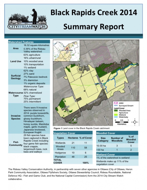
Black Rapids Creek 2014 - Summary Report
Download attachments:
Station Metadata [SNOW-MNR-3311]
STATUS: Active, Seasonal
ABOUT THIS DATA:
The biweekly snow depth (cm) and snow water equivalent (mm) for the Elizabethtown-Kitley region (SNOW-MNR-3311). Field monitoring conducted by the RVCA.
DATA TIME-SERIES:
Biweekly, Field Measurement, Snow Depth (SD); centimeters
Biweekly, Field Measurement, Snow Water Equivalent (SWE); millimeters
LOCATION: UTM 18T [X: 427828.5], [Y: 4955926.6]
SUBWATERSHED: Middle Rideau River
PERIOD OF RECORD (RVCA ARCHIVE): Jan/2014 - Present
OWNER/OPERATOR: Rideau Valley Conservation Authority
DATA AVAILABILITY: Biweekly field monitoring from Oct-June
STATISTICS: NA
DATA UNCERTAINTY:
The RVCA cannot guarantee the accuracy of the provided data. Data accuracy can be affected by a number of factors including, but not limited to: Equipment malfunction/maintenance, regional climate conditions and site disturbance. Users of the RVCA's data tools are cautioned to consider the unverified nature of the information before using it for decisions that concern personal or public safety or the conduct of business.
DATA SOURCES:
MNRF Snow Collection Protocol
CONTACT:
For for more information, please contact:
Published in
Monitoring & Reporting
Station Metadata [SNOW-MNR-3304]
STATUS: Active, Seasonal
ABOUT THIS DATA:
The biweekly snow depth (cm) and snow water equivalent (mm) for the Nolans Corners region (SNOW-MNR-3304). Field monitoring conducted by the RVCA. Statistics have been generated by the RVCA from the period between 1977-2019 (42 years). These statistics include the biweekly median (50th percentile), interquartile range (data range between the daily 25th and 75th percentiles) and the maximum snow water volume measured over the period of record. The median and interquartile range represent the typical normal snow water volume observed at this time of year over the historic record.
DATA TIME-SERIES:
Biweekly, Field Measurement, Snow Depth (SD); centimeters
Biweekly, Field Measurement, Snow Water Equivalent (SWE); millimeters
Biweekly, Lower Quartile (25th Percentile; Historic Normal Water Equivalent); millimeters
Biweekly, Median (50th Percentile; Historic Normal Water Equivalent); millimeters
Biweekly, Upper Quartile (75th Percentile; Historic Normal Water Equivalent); millimeters
LOCATION: UTM 18T [X: 424389.2], [Y: 4975304.8]
SUBWATERSHED: Middle Rideau River
PERIOD OF RECORD (RVCA ARCHIVE): Jan/1977 - Present
OWNER/OPERATOR: Rideau Valley Conservation Authority
DATA AVAILABILITY: Biweekly field monitoring from Oct-June
STATISTICS: RVCA statistics calculated from the 1977-2019 period of record.
a) Upper Quartile (Historic Normal)
Statistics Interval - 1 Year, Recurring
Extraction Interval - Biweekly (15 Days); No Aggregation
Statistics Type: 75th Percentile
Update Frequency: Biweekly
b) Lower Quartile (Historic Normal)
Statistics Interval - 1 Year, Recurring
Extraction Interval - Biweekly (15 Days); No Aggregation
Statistics Type: 25th Percentile
Update Frequency: Biweekly
c) Median (Historic Normal)
Statistics Interval - 1 Year, Recurring
Extraction Interval - Biweekly (15 Days); No Aggregation
Statistics Type: 50th Percentile
Update Frequency: Biweekly
DATA UNCERTAINTY:
The RVCA cannot guarantee the accuracy of the provided data. Data accuracy can be affected by a number of factors including, but not limited to: Equipment malfunction/maintenance, regional climate conditions and site disturbance. Users of the RVCA's data tools are cautioned to consider the unverified nature of the information before using it for decisions that concern personal or public safety or the conduct of business.
DATA SOURCES:
MNRF Snow Collection Protocol
CONTACT:
For for more information, please contact:
Published in
Monitoring & Reporting
Station Metadata [SNOW-MNR-3306]
STATUS: Active, Seasonal
ABOUT THIS DATA:
The biweekly snow depth (cm) and snow water equivalent (mm) for the Pierces Corners region (SNOW-MNR-3306). Field monitoring conducted by the RVCA. Statistics have been generated by the RVCA from the period between 1977-2019 (42 years). These statistics include the biweekly median (50th percentile), interquartile range (data range between the daily 25th and 75th percentiles) and the maximum snow water volume measured over the period of record. The median and interquartile range represent the typical normal snow water volume observed at this time of year over the historic record.
DATA TIME-SERIES:
Biweekly, Field Measurement, Snow Depth (SD); centimeters
Biweekly, Field Measurement, Snow Water Equivalent (SWE); millimeters
Biweekly, Lower Quartile (25th Percentile; Historic Normal Water Equivalent); millimeters
Biweekly, Median (50th Percentile; Historic Normal Water Equivalent); millimeters
Biweekly, Upper Quartile (75th Percentile; Historic Normal Water Equivalent); millimeters
LOCATION: UTM 18T [X: 444984.3], [Y: 4988113.9]
SUBWATERSHED: Lower Rideau River
PERIOD OF RECORD (RVCA ARCHIVE): Jan/1977 - Present
OWNER/OPERATOR: Rideau Valley Conservation Authority
DATA AVAILABILITY: Biweekly field monitoring from Oct-June
STATISTICS: RVCA statistics calculated from the 1977-2019 period of record.
a) Upper Quartile (Historic Normal)
Statistics Interval - 1 Year, Recurring
Extraction Interval - Biweekly (15 Days); No Aggregation
Statistics Type: 75th Percentile
Update Frequency: Biweekly
b) Lower Quartile (Historic Normal)
Statistics Interval - 1 Year, Recurring
Extraction Interval - Biweekly (15 Days); No Aggregation
Statistics Type: 25th Percentile
Update Frequency: Biweekly
c) Median (Historic Normal)
Statistics Interval - 1 Year, Recurring
Extraction Interval - Biweekly (15 Days); No Aggregation
Statistics Type: 50th Percentile
Update Frequency: Biweekly
DATA UNCERTAINTY:
The RVCA cannot guarantee the accuracy of the provided data. Data accuracy can be affected by a number of factors including, but not limited to: Equipment malfunction/maintenance, regional climate conditions and site disturbance. Users of the RVCA's data tools are cautioned to consider the unverified nature of the information before using it for decisions that concern personal or public safety or the conduct of business.
DATA SOURCES:
MNRF Snow Collection Protocol
CONTACT:
For for more information, please contact:
Published in
Monitoring & Reporting

Station Metadata [SNOW-MNR-3310]
STATUS: Active, Seasonal
ABOUT THIS DATA:
The biweekly snow depth (cm) and snow water equivalent (mm) for the Manotick, Ontario region (SNOW-MNR-3310). Field monitoring conducted by the RVCA.
DATA TIME-SERIES:
Biweekly, Field Measurement, Snow Depth (SD); centimeters
Biweekly, Field Measurement, Snow Water Equivalent (SWE); millimeters
LOCATION: UTM 18T [X: 444445.2], [Y: 5010783.4]
SUBWATERSHED: Lower Rideau River
PERIOD OF RECORD (RVCA ARCHIVE): Jan/2008 - Present
OWNER/OPERATOR: Rideau Valley Conservation Authority
DATA AVAILABILITY: Biweekly field monitoring from Oct-June
STATISTICS: NA
DATA UNCERTAINTY:
The RVCA cannot guarantee the accuracy of the provided data. Data accuracy can be affected by a number of factors including, but not limited to: Equipment malfunction/maintenance, regional climate conditions and site disturbance. Users of the RVCA's data tools are cautioned to consider the unverified nature of the information before using it for decisions that concern personal or public safety or the conduct of business.
DATA SOURCES:
MNRF Snow Collection Protocol
CONTACT:
For for more information, please contact:
Published in
Monitoring & Reporting

More...
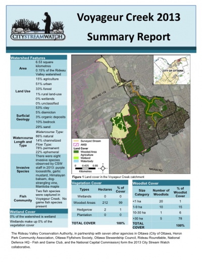
City Stream Watch 2013 - Summary Report

Download attachments: