outdoor-ed-8.jpeg
outdoor-ed-3.jpeg
outdoor-ed-1.jpeg
IMG_70291
IMG_7308
2018-Baxter-Day-Camps
Slide
images/Unknown-2.jpeg
Rain on Monday has pushed water levels in the Ottawa River above the peak reached last week. This Flood Warning is specific to areas around Lac Deschene, at Petrie Island and at Boise Village, east of Cumberland. A short-lived peak can be expected on Wednesday. Rain, possible on Thursday but probable for Friday and through the weekend, is expected to increase levels further. Peak elevation at Britannia last week was 59.924 metres above sea level. At 10:00 this morning, the level was 60 metres. Downstream of the Chaudiere Falls the peak level last week was 44.09 metres. The measurement this…

Megan Peacock

Additional Info

Chelsey Ellis

Additional Info

Rain forecast for the first week of May can be expected to cause water levels to rise significantly in the Ottawa River. Rainfall forecast for today could raise levels to what were reached last week. Additional rain forecast to fall this week can be expected to at least maintain levels and possibly cause further increases.around Lac Deschene, at Petrie Island and at Boise Village, east of Cumberland. Within the Rideau watershed, levels will increase but no flooding issues are expected at this time with the exception of Bobs and Christie Lakes which have continued to have high levels since the…

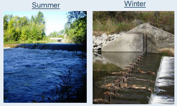
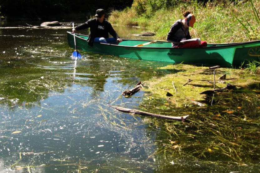
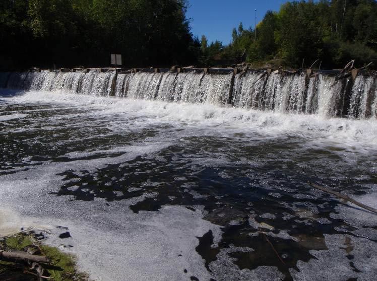
The Hearts Desire Weir is a low-head inline structure operated seasonally on the Jock River between two communities, Hearts Desire and Stonebridge. The Jock River is a tributary river to the Rideau River located about 900 m downstream of the weir. The weir was constructed in 1975 to: provide higher summer flows and thereby improve habitat conditions for fish and wildlife; ensure adequate water for livestock watering; provide community ponds for fire protection and community beautification; and improve the year-round appearance of the river and lessen the likelihood of future pollution problems resulting from expanding urbanization.  

Over the last 42 years, a great deal about the watercourse and its neighbouring communities has changed, including:

  • concepts on how rivers and watersheds are managed,
  • occupational health and safety risks associated with the annual installation and removal of the weir,
  • concerns from local community groups about slope failures and erosion upstream of the weir; and,
  • indications from whitewater enthusiasts that the weir site is considered to be hazardous by canoeists and kayakers.

In February 2008, the RVCA Board of Directors approved the development of a plan to decommission the Hearts Desire Weir. In response to public input, a restoration plan for the Jock River and its riverbank was also initiated. The decommissioning plan and restoration plan is now in draft form and ready for public input.

3HeartsDesire
2HeartsDesire
1HeartsDesire

The RVCA is committed to maintaining the current operation of the weir until such a time that the Board of Directors chooses an alternative.

For more information, contact Terry Davidson at or 613-692-3571 ext. 1107 or Mike Yee at or ext. 1176.


Resources

Shoreline Property Owner Package, November 2013

Hearts Desire Riparian Restoration Concept Report, October 2011

hd-Riparian_Restoration_PlanFINAL.pdf

Appendix I: Community Representatives Meeting Minutes - September 2010 and Open House Meeting Notes - December 2010

Parish Geomorphic Hydraulic Modeling Technical Report, July 2011(11 mb)

J.L. Richards and Associates Ltd. Jock River Conservation Study, June 1968

The rise of flood waters on the Ottawa River is slow but continuing and is approaching the 1:10 year flood frequency*. The slow rise of flood waters on the Ottawa River will continue today aided by runoff from the overnight rains. Levels had dropped yesterday on Lac Deschene but have risen again today. Downstream of Chaudiere Falls the rate of rise decreased slightly but that is likely to change with the impact of the rain. The locations at risk of flooding on the Ottawa River within the jurisdiction of the Rideau Valley Conservation Authority are communities around Lac Deschene (e.g.…
The drought status in the Rideau River watershed that was left at “Minor” after a dry year in 2016 is, by this statement, reduced to “Normal”. The uncertainty that prompted holding the Minor status through the winter was because it wasn’t clear what state groundwater resources had been left at as the onset of winter arrived. With a period of warmer temperatures and the loss of much of the snow cover by late March, there was an opportunity to access the monitoring wells in the Rideau River watershed. Measurements indicated that groundwater levels had been restored to about the long…
As water levels and flows in the Rideau River watershed recede, levels on the Ottawa River have been rising. Rain on Saturday and Sunday had little impact on stream flows anywhere in the Rideau watershed. Rain forecast for Wednesday and Thursday of about 30 millimetres can be expected to cause flows to rise by as much as 50 cubic metres per second on the Rideau. This will not be enough to bring on the return of flooding in those areas recently affected. Levels on three of the four Rideau Canal reservoir lakes have been declining very slowly but are sensitive…
With access ways to the waterfront properties on the Long Reach of the Rideau River (Kars to Burritts Rapids) again passable, the Flood Warning, in place for the last week, is now reduced to Flood Watch.  Rain forecast for Saturday evening into Sunday is expected to cause an upturn in flows in the Rideau system. However, flows are expected to have receded sufficiently by then that the increase will have a minor impact. The expectation is that flows, as measured at the recording station at Carleton University, will increase to about 280 cubic metres per second (cms) by early Monday.…
April 12, 2017

Water Quality Mapping Tool

Written by

Access water chemistry results by searching your area of interest or zooming into an area and selecting a sampling site. 


Page 55 of 82

Contact Us

Address:
Rideau Valley Conservation Authority
3889 Rideau Valley Drive
Manotick, Ontario K4M 1A5

Phone:
613-692-3571, 1-800-267-3504

Email:

Hours:

Regular Hours: Monday to Friday, 8:30 a.m. to 4:30 p.m.

Member of: conservation ontario