May 25, 2018

Nichols Creek Hazard Mapping Study

Super User

Project Status: Complete

The Rideau Valley Conservation Authority (RVCA) has completed a hazard mapping study for Nichols Creek from the Montague Boundary Road to the Jock River.

These maps are typically known as “floodplain mapping” and they show areas that are prone to natural hazards such as flooding, erosion and natural environment features such as wetlands. 

When completed, the mapping will be used by the City of Ottawa when updating their Official Plan and Zoning Schedules and in the review of development applications under the Planning Act. RVCA will also use the mapping to guide the review of development applications submitted under the Province’s Development, Interference with Wetlands and Alterations to Shorelines and Watercourses Regulation.

Members of the public are encouraged to attend our open house (date to be announced) and/or provide comments on the mapping below. Conservation Authority staff welcome historical records of past flood events, news clippings, photographs and even anecdotal stories to help confirm the reasonableness of calculations and resulting hazard mapping. For those unable to attend the open house, comments can be sent to Ferdous Ahmed, RVCA Senior Water Resources Engineer at .

These mapping studies are being completed as part of the City of Ottawa Hazard Mapping Project.

These studies are being done through a collaboration — known as the City of Ottawa Hazard Mapping Project — involving the City of Ottawa and the Mississippi Valley, Rideau Valley and South Nation Conservation Authorities. The City recognized a need to update its zoning schedules based on up-to-date flood risk mapping and has provided contributions enabling the Conservation Authorities to move ahead with these studies sooner than would otherwise be possible. The RVCA is currently working on several studies in the Ottawa area. Get more details on RVCA ongoing Flood Risk/Hazard Mapping Studies here.


May 22, 2018, OTTAWA — The City Stream Watch Program is looking for volunteer “scientists” to help monitor, protect and cleanup Ottawa streams. Now is the best time to get involved — a Stream Watch Training Session will be held for volunteers on Saturday, June 2. The training session will welcome new volunteers and introduce them to the basics of stream sampling and environmental data collection.  “The City Stream Watch program is driven by volunteer participation and gives the community a chance to contribute to the health of their local streams,” said Chelsey Ellis, City Stream Watch Coordinator. “By helping…

City Stream Watch 2017 Summary Report

Becketts Creek - 2017 Catchment Report

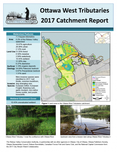
Ottawa West Tributaries - 2017 Catchment Report

Pinecrest Creek - 2017 Catchment Report

Stevens Creek - 2017 Catchment Report

May 17, 2018 — RIDEAU VALLEY WATERSHED — More than 30 new classes will be visiting the Rideau Valley Conservation Authority’s two flagship outdoor education centres thanks to special funding through the Rideau Valley Conservation Foundation, the Ottawa Community Foundation and TD Friends of the Environment. Subsidies are now available to cover busing costs for schools visiting Baxter and Foley Mountain. Separate subsides are also available to priority schools visiting Baxter who need assistance covering program and busing costs. Baxter Conservation Area, located in the City of Ottawa near Kars and Foley Mountain Conservation Area in Westport will welcome some…
May 15, 2018 – By this statement the Flood Warning issued on April 30 for Bobs and Christie Lakes is terminated. The water level on Bobs Lake has receded to the ‘Full Supply’ threshold. No significant rain is presently forecast for the next four days. Therefore, levels on both Bobs and Christie Lakes can be expected to continue to recede toward normal summer levels over the rest of the week. Rain forecast for Saturday and Sunday is not expected to be enough to raise levels again. Caution is still needed around lakes and rivers with water still cold and above…
Page 42 of 82

Contact Us

Address:
Rideau Valley Conservation Authority
3889 Rideau Valley Drive
Manotick, Ontario K4M 1A5

Phone:
613-692-3571, 1-800-267-3504

Email:

Hours:

Regular Hours: Monday to Friday, 8:30 a.m. to 4:30 p.m.

Member of: conservation ontario