


RVCA (1141)
Children categories
Department (68)
Main Office Phone Numbers : 613-692-3571 / 1-800-267-3504
Staff Directory
Project Status: Complete
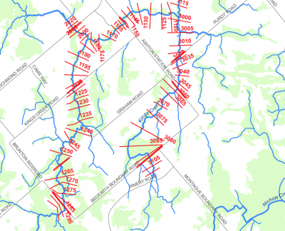
The Rideau Valley Conservation Authority (RVCA) has completed a hazard mapping study for Kings Creek — a tributary of the Jock River — from the Brunton Side Road to the Jock River.
These maps are typically known as “floodplain mapping” and they show areas that are prone to natural hazards such as flooding, erosion and natural environment features such as wetlands.
When completed, the mapping will be used by the City of Ottawa and the Townships of Beckwith and Montague when updating their Official Plan and Zoning Schedules and in the review of development applications under the Planning Act. RVCA will also use the mapping to guide the review of development applications submitted under the Province’s Development, Interference with Wetlands and Alterations to Shorelines and Watercourses Regulation.
Members of the public are encouraged to attend our open house (date to be announced) and/or provide comments on the mapping below. Conservation Authority staff welcome historical records of past flood events, news clippings, photographs and even anecdotal stories to help confirm the reasonableness of calculations and resulting hazard mapping. For those unable to attend the open house, comments can be sent to Ferdous Ahmed, RVCA Senior Water Resources Engineer at .
These mapping studies are being completed as part of the City of Ottawa Hazard Mapping Project.
These studies are being done through a collaboration — known as the City of Ottawa Hazard Mapping Project — involving the City of Ottawa and the Mississippi Valley, Rideau Valley and South Nation Conservation Authorities. The City recognized a need to update its zoning schedules based on up-to-date flood risk mapping and has provided contributions enabling the Conservation Authorities to move ahead with these studies sooner than would otherwise be possible. The RVCA is currently working on several studies in the Ottawa area.
Spring Water Awareness Program (S.W.A.P.) Resources

Free online resources available for all teachers and group leaders at https://www.rvca.ca/outdoor-education/spring-water-awareness-program.
Additional Info
- Grade K, 1, 2, 3, 4, 5, 6
- Season Spring
Snowshoeing

Come and experience one of the oldest forms of transportation in Canada! Students will learn how to safely travel with snowshoes and, once comfortable, follow the snowshoe trail through the forest and maybe even try snowshoe games.
Additional Info
- Grade 3, 4, 5, 6, 7, 8, 9, 10, 11, 12
- Season Winter
Mississippi-Rideau Staff Meet with Local Businesses Owners
If you are concerned about any work taking place near a lake, river, stream, floodplain, steep slope or wetland, please contact us. Send us details on the location (civic address, intersection, waterbody, lot and concession, municipality) and the type of work being done. Photos are always helpful. We can advise you if permits are required and/or in place and take appropriate steps to ensure any adverse impacts are addressed.
More...
To make a Section 28 application:
- Contact the RVCA while you are in the early stages of planning your project. It will save you time and keep your schedule on track. Your first step is to determine if you require Conservation Authority approval. E-mail us at or speak to an RVCA Resource Specialist at 613-692-3571 || 1-800-267-3504 (extension 1193 or 1132). They will confirm that you need a permit and provide you with the preliminary information you will require to submit an application.
- Download and complete the RVCA Application for Development (includes Minimum Application Requirements). You may also contact a Resource Specialist for a paper copy or visit our office to pick up a copy.
- Refer to the Application Fee Schedule to determine the category of works and the application type. Forward your permit application form and other required information including plans drawn to scale, a survey, elevation information, etc. Please see the RVCA's Application for Development for a complete checklist. The application fee is paid at the time of filing the application with the RVCA.
Click here for a full list of forms, fees and resources.
Spring Water Awareness Program (S.W.A.P.) Resources

The RVCA is pleased to offer resources to teachers interested in promoting spring water awareness. As winter turns to spring, snow and ice begin to melt and waterways begin to fill up with cold, fast moving water. Children are often interested in exploring rushing streams and thawing ponds during the warm days of spring. However, these areas can be unsafe and it is important to teach students the dangers of these areas. Please go to the following link for more information: www.rvca.ca/outdoor-education/spring-water-awareness-program
Additional Info
- Grade 1, 2, 3, 4, 5, 6
- Season Spring
Conservation Authorities and Resource Management

Conservation Authorities are local watershed management agencies that deliver services and programs that protect and manage water and other natural resources. Students will learn how CAs work and the role they play in environmental protection and management. The morning consists of a PowerPoint presentation and case studies with an interpretive hike focusing on resource management in the afternoon. (Full-day Program)
Additional Info
- Grade 9, 10, 11, 12
- Season Spring, Summer, Fall
The RVCA is committed to ensuring we provide a welcoming, safe, barrier-free environment for everyone. Our commitment applies to the following areas:
- Customer Service
- Recruitment and Employment with the RVCA
- Design of Public Spaces (Conservation Areas)
- Information and Communications
RVCA’s Accessibility Standards and Accessible Customer Service Policy support the Accessibility for Ontarians with Disabilities Act.
Annual Status Updates
Request for RVCA Documents in an Accessible Format
We will do our best to provide documents in various formats upon request. You can use our online Request for RVCA Documents in Accessible Format form or call us at 613-692-3571 or toll-free at 1-800-267-3504.
Accessibility Feedback Form
We value your feedback on the RVCA’s accessibility and customer service. You can provide feedback through our online Accessibility Feedback Form or call us at 613-692-3571 or toll-free at 1-800-267-3504.
Please note: Information collected in these forms are collected under the Municipal Freedom of Information and Protection of Privacy Act. Personal information on these forms are collected under the authority of Ontario Regulation 429/07, Accessibility Standards for Customer Service. The information will be used to process this form and will be kept on file to facilitate improvements to the RVCA's customer service policies, practices and procedures. Questions about this collection should be directed to the FOI Co-ordinator at Box 599, 3889 Rideau Valley Drive, Manotick ON K4M1A5 or 613-692-3571.