


RVCA (1136)
Children categories
Department (67)
Main Office Phone Numbers : 613-692-3571 / 1-800-267-3504
Staff Directory
Project Status: Complete
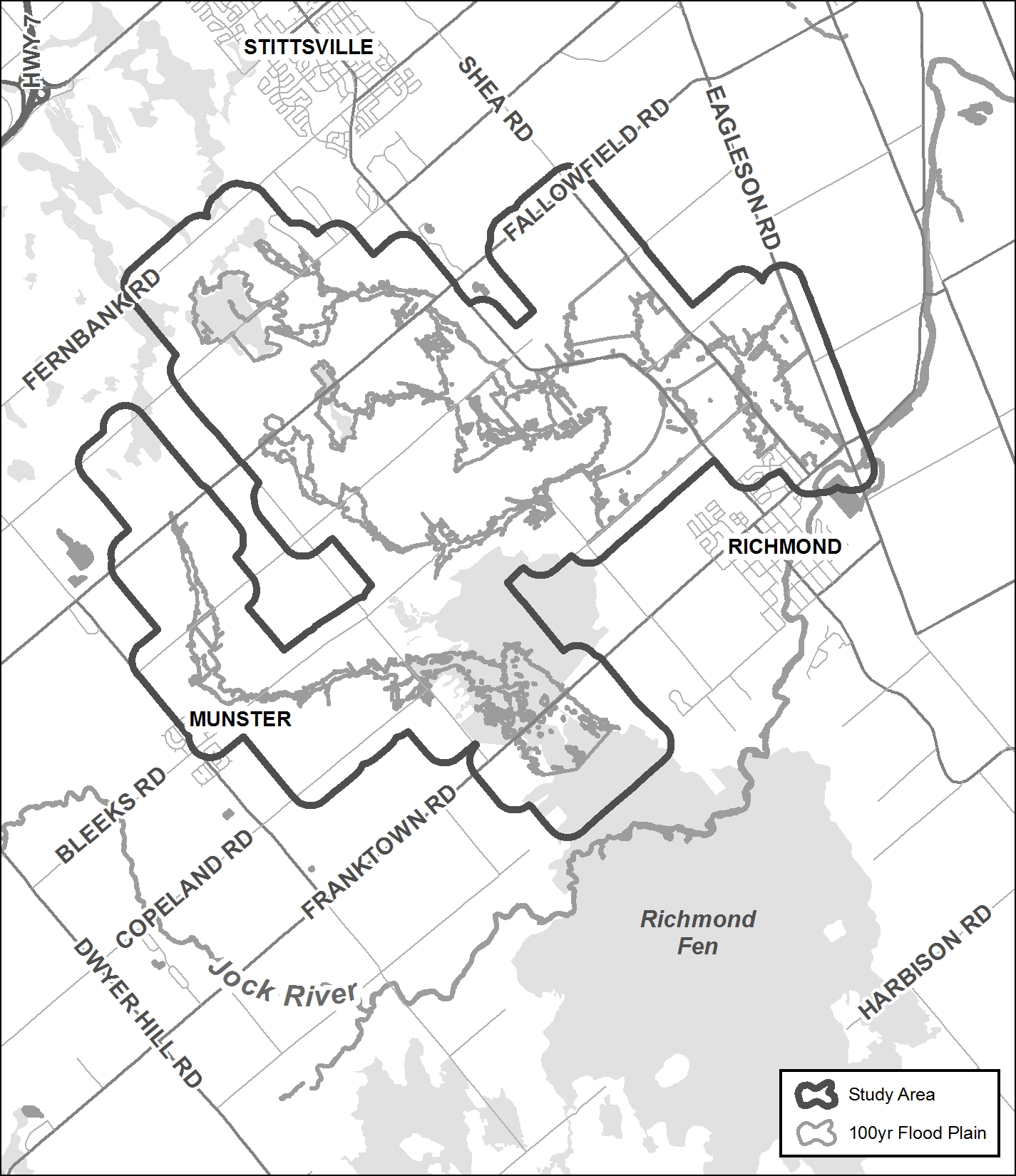
The Rideau Valley Conservation Authority (RVCA) has completed a hazard mapping study for both the Hobbs Drain and Flowing Creek — tributaries of the Jock River.
These maps are typically known as “floodplain mapping” and they show areas that are prone to natural hazards such as flooding, erosion and natural environment features such as wetlands.
When completed, the mapping will be used by the City of Ottawa when updating their Official Plan and Zoning Schedules and in the review of development applications under the Planning Act. RVCA will also use the mapping to guide the review of development applications submitted under the Province’s Development, Interference with Wetlands and Alterations to Shorelines and Watercourses Regulation.
Members of the public are encouraged to attend our open house (date to be announced) and/or provide comments on the mapping below. Conservation Authority staff welcome historical records of past flood events, news clippings, photographs and even anecdotal stories to help confirm the reasonableness of calculations and resulting hazard mapping. For those unable to attend the open house, comments can be sent to Ferdous Ahmed, RVCA Senior Water Resources Engineer at .
These mapping studies are being completed as part of the City of Ottawa Hazard Mapping Project.
These studies are being done through a collaboration — known as the City of Ottawa Hazard Mapping Project — involving the City of Ottawa and the Mississippi Valley, Rideau Valley and South Nation Conservation Authorities. The City recognized a need to update its zoning schedules based on up-to-date flood risk mapping and has provided contributions enabling the Conservation Authorities to move ahead with these studies sooner than would otherwise be possible. The RVCA is currently working on several studies in the Ottawa area. Get more details on RVCA ongoing Flood Risk/Hazard Mapping Studies here.
Warmer Temperatures and Rain Could Cause Unsafe Conditions on Rivers and Lakes Throughout Rideau Watershed
Warmer Temperatures and Rain Could Cause Unsafe Conditions on Rivers and Lakes Throughout Rideau Watershed
Announcement: Goulbourn Wetland Complex No Longer Exempted from RVCA's Regulated Area
During the spring freshet we assess hundreds of headwater drainage features at various remote locations throughout the Rideau Valley watershed. We need your help conducting these assessments.
What to Expect
- You’ll spend a lot of time travelling to remote areas in an RVCA vehicle with one of our professionals. Your day will typically start at 8:00 a.m. and end at 4:00 p.m., however some days may be longer.
- You’ll be navigating steep slopes; entering cold and fast flowing water wearing hip waders; and sometimes working in inclement weather (but never in a storm).
When
- Tentative dates are March through April. Depending on the timing of the spring freshet, this opportunity may start earlier and/or end later
Skills and Competencies Required
- To be successful in this role, you will already need to be comfortable travelling long distances, working in cold temperatures in and around water, wading through streams and walking in difficult terrain. We are looking for volunteers with good communication skills, positive attitude and the ability to work in teams.
Skills and Competencies To Be Acquired
You will gain hands on experience:
- applying the Ontario Stream Assessment Protocol module to assess headwater drainage features
- wearing chest waders and working in small streams
- how to operate a multiparameter water chemistry probe
- how to measure surface water velocities
- recognizing sediment deposition
- detecting fish migration barriers
- how to identify various types of vegetation
Be Prepared
- You will need your own transportation to and from RVCA headquarters at 3889 Rideau Valley Drive in Manotick
- Read the RVCA's Participant Guide
You will need to provide:
- your own warm and water-resistant clothing (dressing in layers is a good idea);
- your own footwear and extra socks – wear closed toe shoes to get around, to wear chest waders you will require a thick pair of socks with length (no ankle socks);
- your own lunch, snacks and beverages.
We Supply
- electronic copy of the OSAP manual module: Assessing Headwater Drainage Features
- chest waders and reflective vests;
- sunscreen and DEET bug repellant;
- sampling equipment;
- supervision and instruction.
RVCA Contact
Love being outside? Enjoy working with children? Looking to complete your 40 hours of volunteering for high school? Baxter Conservation Area is looking for mature, enthusiastic volunteers to help out with our nature-themed summer day camp. Volunteers must be going into grade 9 in the fall or older. Camp includes nature hikes, pond studies, crafts, games and swimming at Baxter's sandy beach.
For more information, please contact the Baxter team at:
613-489-3592