


Baxter Outdoor and Environmental Education Programs
Baxter Conservation Area offers outdoor and environmental education programs for students and community groups from preschool to grade 12 and beyond. Join us in our outdoor classroom and give your students the opportunity to explore and connect with nature. Our education programs provide students and visitors with interactive, hands-on, curriculum-based experiences where they will learn about the natural world and their relationship with it. We also offer outdoor education programs where students will learn navigation and outdoor survival skills as well.
Baxter can accommodate up to 60 students per day. All equipment is included in our programs and each program runs approximately 1.5 hours in length. Below please find descriptions of each of the programs we offer. Descriptions are offered as general guidelines — if there are specific objectives that you would like to accomplish, please let us know. Although grade levels are recommended for each program, these are also only guidelines. Please select any desired fields to narrow your search.
| Half Day Program | $200 / group * | maximum 30 students, 90 minutes with an RVCA instructor |
| Full Day Program | $275 / group * | maximum 30 students, two 90 minutes with an RVCA instructor |
| Self-directed | $2.50/person * | Interested in just visiting the conservation area with your class but not booking a program? The cost is $2.50/person. This does not include the use of buildings other than access to public washrooms. To reserve facilities, contact staff. Staff must still be contacted to book a self-directed visit. |
| Overnight Tent Camping (accommodations only) | 1-15 people - $75/night * 16-30 people - $150/night * 30+ people - contact for pricing * Additional buildings also available for rent (link to facility rentals) |
Take you class on an overnight adventure to our group camping area! Plan your own activities or book our education staff to provide programming during your stay (see above for pricing). |
* plus applicable taxes
Baxter’s Cancellation Policy: A minimum of fifteen (15) business days notice is required to cancel education programs at Baxter Conservation Area.
This policy gives schools/groups on our waiting list sufficient time to try and fill the program opening. If Baxter Conservation Area is notified of a cancellation less than 15 business days in advance of your scheduled visit, a cancellation fee of $50.00 will be charged.
In the event of severe weather conditions (i.e. thunderstorms, snowstorms, etc.), Baxter staff will make contact with your school/group by 7:00 AM the morning of your trip if we need to re-schedule or cancel the program on that day. There will be no charge for a cancellation made due to school bus cancellations or severe weather conditions on the day of your trip.
Baxter Education Program Descriptions

RVCA (1140)
Children categories
Department (68)
Main Office Phone Numbers : 613-692-3571 / 1-800-267-3504
Staff Directory
Kemptville Creek Flood Risk Mapping - Floodplain Delineation Revision 3 (June 3, 2011)
Kemptville Creek Flood Risk Mapping - Floodplain Delineation Revision 2 (June 3, 2011)
Kemptville Creek Flood Risk Mapping - Floodplain Delineation Revision 1 (June 3, 2011)
Dollars Available to Plant Trees — Free Site Visits
Wet Weather in Most of the Rideau Watershed but Record Rain and Flooding in North Gower
Floodwaters Receding Slowly
More...
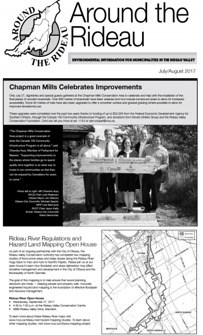
The Rideau Valley Conservation Authority (RVCA) is conducting several hazard mapping studies on watercourses within the City of Ottawa and the RVCA area of jurisdiction. For some watercourses, old mapping will be updated; and for others, hazards maps will be created for the first time.
Project Status: Complete
Hogs Back to Kars & Kars to Burritts Rapids
The Rideau Valley Conservation Authority (RVCA) has completed two hazard mapping studies for the Rideau River: Hogs Back to Kars and Kars to Burritts Rapids. These studies update existing mapping in some areas and new mapping in others.
These maps are typically known as “floodplain mapping” and they show areas that are prone to natural hazards such as flooding, erosion and natural environment features such as wetlands. Both Rideau River studies look at identifying two main types of hazards along these stretches of the watercourse: flooding and slope stability.
When completed, the mapping will be used by the City of Ottawa and the Municipality of North Grenville when updating their Official Plan and Zoning Schedules and in the review of development applications under the Planning Act. RVCA will also use the mapping to guide the review of development applications submitted under the Province’s Development, Interference with Wetlands and Alterations to Shorelines and Watercourses Regulation.
Members of the public are encouraged to attend our open house and/or provide comments on the mapping below. Conservation Authority staff welcome historical records of past flood events, news clippings, photographs and even anecdotal stories to help confirm the reasonableness of calculations and resulting hazard mapping. For those unable to attend the open house, comments can be sent to Ferdous Ahmed, RVCA Senior Water Resources Engineer at .
These mapping studies are being completed as part of the City of Ottawa Hazard Mapping Project.
These studies are being done through a collaboration — known as the City of Ottawa Hazard Mapping Project — involving the City of Ottawa and the Mississippi Valley, Rideau Valley and South Nation Conservation Authorities. The City recognized a need to update its zoning schedules based on up-to-date flood risk mapping and has provided contributions enabling the Conservation Authorities to move ahead with these studies sooner than would otherwise be possible. The RVCA is currently working on several studies in the Ottawa area.