Super User
Kings Creek Flood Risk Mapping Study, September 2017
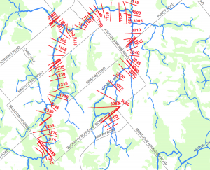
Kings Creek Hazard Mapping Study
Project Status: Complete
The Rideau Valley Conservation Authority (RVCA) has completed a hazard mapping study for Kings Creek — a tributary of the Jock River — from the Brunton Side Road to the Jock River.
These maps are typically known as “floodplain mapping” and they show areas that are prone to natural hazards such as flooding, erosion and natural environment features such as wetlands.
When completed, the mapping will be used by the City of Ottawa and the Townships of Beckwith and Montague when updating their Official Plan and Zoning Schedules and in the review of development applications under the Planning Act. RVCA will also use the mapping to guide the review of development applications submitted under the Province’s Development, Interference with Wetlands and Alterations to Shorelines and Watercourses Regulation.
Members of the public are encouraged to attend our open house (date to be announced) and/or provide comments on the mapping below. Conservation Authority staff welcome historical records of past flood events, news clippings, photographs and even anecdotal stories to help confirm the reasonableness of calculations and resulting hazard mapping. For those unable to attend the open house, comments can be sent to Ferdous Ahmed, RVCA Senior Water Resources Engineer at .
These mapping studies are being completed as part of the City of Ottawa Hazard Mapping Project.
These studies are being done through a collaboration — known as the City of Ottawa Hazard Mapping Project — involving the City of Ottawa and the Mississippi Valley, Rideau Valley and South Nation Conservation Authorities. The City recognized a need to update its zoning schedules based on up-to-date flood risk mapping and has provided contributions enabling the Conservation Authorities to move ahead with these studies sooner than would otherwise be possible. The RVCA is currently working on several studies in the Ottawa area.
Spring Water Awareness Program (S.W.A.P.) Resources
Free online resources available for all teachers and group leaders at https://www.rvca.ca/outdoor-education/spring-water-awareness-program.
Snowshoeing
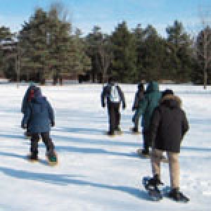
Come and experience one of the oldest forms of transportation in Canada! Students will learn how to safely travel with snowshoes and, once comfortable, follow the snowshoe trail through the forest and maybe even try snowshoe games.
Mississippi-Rideau Staff Meet with Local Businesses Owners
MISSISSIPPI-RIDEAU REGION, September 11, 2017 — Staff from the Mississippi-Rideau Source Protection Region (MRSPR) successfully met with 61 business owners in the communities of Westport, Montague, North Grenville and Mississippi Mills this summer to discuss chemical products that could pose a risk to four municipal drinking water systems. Business owners were welcoming and helpful — allowing staff to better understand the chemicals that are being used in wellhead protection areas.
MRSPR staff completed this work on behalf of the local municipalities who are striving to meet the requirements of the Ontario Clean Water Act. These outreach projects promote the long-term protection of drinking water sources. The locally produced and supported Source Protection Plan sets out ways to ensure long-term protection of municipal drinking water sources.
“We need to be extra cautious of certain chemicals that are denser than water,” explains Brian Stratton, MRSPR Co-Manager. “If released into the environment, the chemicals can cause groundwater contamination that is very difficult and expensive to clean-up. We are happy to work with local businesses and landowners to ensure we are all being good stewards.”
MRSPR staff provided educational materials to business owners to inform them about the municipal drinking water source and how they can continue to do their part to help protect it. This work would not have been possible if it was not for the cooperative and friendly interactions with local businesses. As good stewards for the environment, local businesses are conscious of the chemicals they use and how to dispose of them. These combined efforts are an important step towards ensuring that future generations have access to safe, clean water sources.
The Mississippi-Rideau Source Protection Region is made up of the Mississippi Valley and Rideau Valley watersheds. The Mississippi Valley and Rideau Valley Conservation Authorities support the ongoing work of the Mississippi-Rideau Source Protection Region committee and staff.
For more information on best management practices in wellhead protection areas for your home or business visit mrsourcewater.ca.
Report a Concern
If you are concerned about any work taking place near a lake, river, stream, floodplain, steep slope or wetland, please contact us. Send us details on the location (civic address, intersection, waterbody, lot and concession, municipality) and the type of work being done. Photos are always helpful. We can advise you if permits are required and/or in place and take appropriate steps to ensure any adverse impacts are addressed.