

Super User
RVCA By-laws
| File | ||
|---|---|---|
| By-law No. 1—Administrative By-law | Download | |
Becketts Creek Flood Risk Mapping Study, October 2018
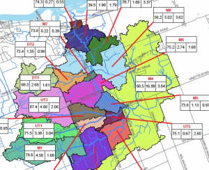
Becketts Creek Hazard Mapping Study
Project Status: Complete
The Rideau Valley Conservation Authority (RVCA) has completed a hazard mapping study for Becketts Creek from Sarsfield Road to the Ottawa River.
These maps have been traditionally known as “floodplain mapping” or “regulation mapping” and they show areas that are prone to natural hazards such as flooding, erosion and natural environment features such as wetlands.
When completed, the mapping will be used by the City of Ottawa when updating their Official Plan and Zoning Schedules and in the review of development applications under the Planning Act. RVCA will also use the mapping to guide the review of development applications submitted under the Development, Interference with Wetlands and Alterations to Shorelines and Watercourses Regulation.
Members of the public are encouraged to attend the open house (details below) and/or provide comments on the mapping below. Conservation Authority staff welcome historical records of past flood events, slope failure, erosion, news clippings, photographs and even anecdotal stories to help confirm the reasonableness of calculations and resulting hazard mapping For those unable to attend the open house, comments can be sent to Ferdous Ahmed, RVCA Senior Water Resources Engineer at .
These mapping studies are being completed as part of the City of Ottawa Hazard Mapping Project.
These studies are being done through a collaboration — known as the City of Ottawa Hazard Mapping Project — involving the City of Ottawa and the Mississippi Valley, Rideau Valley and South Nation Conservation Authorities. The City recognized a need to update its zoning schedules based on up-to-date flood risk mapping and has provided contributions enabling the Conservation Authorities to move ahead with these studies sooner than would otherwise be possible. The RVCA is currently working on several studies in the Ottawa area.
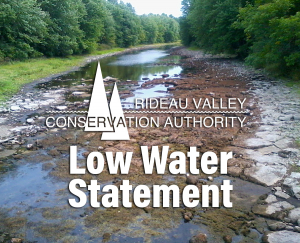
Low Water Status Update in Rideau River Watershed

September 27, 2018 – This statement is to advise that the low water status in the Rideau River watershed has returned to “Normal” except for the Kemptville Creek subwatershed which is at “Minor” Severity, down from “Moderate” Severity.
Rain over the last week pushed totals above what is normal for the time of year at most climate monitoring sites in the region. The forecast is indicating more rainfall next week that will begin to restore streamflows to historical averages.
The exception is at the Environment Canada site in Kemptville which has a 90 day total at 67% of normal, well below the threshold for the Minor severity status of 80%.
Winterization of the Rideau Canal will begin on October 9 and proceed to mid-November. Presently, water levels from Ottawa Locks to Newboro are sufficient for navigation. Further information is available on the Parks Canada Infonet (address below).
Water conservation is recommended for all residents of the Rideau River watershed. Burn bans may still be in effect in some municipalities. Check your municipal website for applicable bylaws. Those who have permits for taking water from surface or groundwater sources are encouraged to reduce their actual taking as much as possible.
Conservation Authority staff continue to monitor conditions and communicate with water managers throughout the watershed. Updates to this message will be issued as conditions warrant.
Other relevant information sources are:
Ministry of Environment and Climate Change: https://www.ontario.ca/page/managing-your-water-well-times-water-shortage
Ontario’s Low Water Response program: https://www.ontario.ca/page/low-water-response-program.
Parks Canada Infonet: https://www.pc.gc.ca/en/lhn-nhs/on/rideau/info/infonet/tirant-deau-draft
RVCA website: www.rvca.ca
Hourly and daily streamflows and water levels: https://www.rvca.ca/watershed-monitoring-reporting/reporting/streamflow-water-levels .
Low Water Status Update in Rideau River Watershed
September 27, 2018 – This statement is to advise that the low water status in the Rideau River watershed has returned to “Normal” except for the Kemptville Creek subwatershed which is at “Minor” Severity, down from “Moderate” Severity.
Rain over the last week pushed totals above what is normal for the time of year at most climate monitoring sites in the region. The forecast is indicating more rainfall next week that will begin to restore streamflows to historical averages.
The exception is at the Environment Canada site in Kemptville which has a 90 day total at 67% of normal, well below the threshold for the Minor severity status of 80%.
Winterization of the Rideau Canal will begin on October 9 and proceed to mid-November. Presently, water levels from Ottawa Locks to Newboro are sufficient for navigation. Further information is available on the Parks Canada Infonet (address below).
Water conservation is recommended for all residents of the Rideau River watershed. Burn bans may still be in effect in some municipalities. Check your municipal website for applicable bylaws. Those who have permits for taking water from surface or groundwater sources are encouraged to reduce their actual taking as much as possible.
Conservation Authority staff continue to monitor conditions and communicate with water managers throughout the watershed. Updates to this message will be issued as conditions warrant.
Other relevant information sources are:
Ministry of Environment and Climate Change: https://www.ontario.ca/page/managing-your-water-well-times-water-shortage
Ontario’s Low Water Response program: https://www.ontario.ca/page/low-water-response-program.
Parks Canada Infonet: https://www.pc.gc.ca/en/lhn-nhs/on/rideau/info/infonet/tirant-deau-draft
RVCA website: www.rvca.ca
Hourly and daily streamflows and water levels: https://www.rvca.ca/watershed-monitoring-reporting/reporting/streamflow-water-levels .
Fall Benthic Sampling
VOLUNTEERS WANTED!
Brief Description
During the fall we sample benthic invertebrates using the kick-and-sweep method throughout the Rideau Valley watershed.
What to Expect
You’ll spend a lot of time traveling to remote areas in an RVCA vehicle with one of our professionals. Your day will typically start at 8:00 a.m. and end at 4:00 p.m., however, some days might be longer. You’ll be walking steep slopes; entering cold and fast flowing water wearing chest waders; canoeing in lakes and sometimes working in inclement weather.
When
- Tentative dates are Monday to Friday, October through to November. Depending on the fall conditions, this opportunity may start earlier and/or end later.
Skills and Competencies Required
- To be successful in this role, you will already need to be comfortable traveling long distances, working in cold temperatures in and around water, wading through streams and walking in difficult terrain. We are looking for volunteers with good communication skills, positive attitude and the ability to work in teams.
Skills and Competencies To Be Acquired
To be successful in this role, you will already need to be comfortable travelling long distances, working in cold temperatures in and around water, wading through streams, wearing chest waders, touching benthic invertebrates and walking in difficult terrain. We are looking for volunteers with good communication skills, positive attitude and able to work in teams.
- Aquatic sampling field experience;
- wearing chest waders and working in streams;
- operating a multiparameter water chemistry probe;
- use of a Secchi disk, a composite sampler, and a Van Doren
- Kick and sweep techniques for benthic invertebrates
Be Prepared
You will need your own transportation to and from RVCA headquarters (3889 Rideau Valley Drive, Manotick.
Read the Participant Guide found in the volunteer section of the RVCA website.
You will need to provide:
- your own warm and water-resistant clothing (dressing in layers is a good idea);
- your own footwear and extra socks – wear closed toe shoes to get around;
- to wear chest waders you will require a thick pair of socks with length (no ankle socks);
- your own lunch, snacks, and beverages.
We Supply
- chest waders and flotation safety equipment;
- sampling equipment, supervision and instruction.
RVCA Contacts
Low Water Status Update in Rideau River Watershed (Sept. 14)

September 14, 2018 – This statement is to advise that the low water status in the Rideau River watershed is still at “Minor” Severity except for the Kemptville Creek sub-watershed which continues to be “Moderate” Severity.
The overall watershed 30 day rainfall is at 72% of normal for the time of year. The 30 day rain measured at Kemptville College is at 42%. Rainfall is slightly higher in the headwater areas of Kemptville Creek but most appears to have infiltrated into the ground, rather than into the Creek, with flows just 1.3% of normal. Aquatic species will be increasingly stressed as available pools shrink, temperatures rise and oxygen concentrations decline.
An obvious indicator of drought stress are trees with leaves changing colour earlier than usual.
The Rideau Canal reservoir lake levels are as little as 2 centimetres (Wolfe Lake) to 19 cm (Upper Rideau) below levels normally reached at this time of year. Navigation in the north flowing sector is not presently at risk. Further information is available on the Parks Canada Infonet (address below).
Water conservation is recommended for all residents of the Rideau River watershed. Burn bans may still be in effect in some municipalities. Check your municipal website for applicable bylaws. Those who have permits for taking water from surface or groundwater sources are encouraged to reduce their actual taking as much as possible.
Conservation Authority staff continue to monitor conditions and communicate with water managers throughout the watershed. Updates to this message will be issued as conditions warrant.
Other relevant information sources are:
Ministry of Environment and Climate Change: https://www.ontario.ca/page/managing-your-water-well-times-water-shortage
Ontario’s Low Water Response program: https://www.ontario.ca/page/low-water-response-program.
Parks Canada Infonet: https://www.pc.gc.ca/en/lhn-nhs/on/rideau/info/infonet/tirant-deau-draft
RVCA website: www.rvca.ca
Hourly and daily streamflows and water levels: https://www.rvca.ca/watershed-monitoring-reporting/reporting/streamflow-water-levels .
Low Water Status Continued in Rideau River Watershed

August 30, 2018 – This statement is to advise that the low water status in the Rideau River watershed remains at “Minor” Severity except for the Kemptville Creek sub-watershed which continues to be “Moderate” Severity.
Flow in Kemptville Creek has continued to be very low. The amount of rain measured in the Kemptville Creek sub-watershed for the same time period is well below the historical average at both Kemptville and at the Brockville Airport near the Creek headwaters The impact of the low flow is that aquatic creatures living in the Creek are confined to smaller and smaller pools that are getting warmer and becoming short of oxygen.
The average rainfall on the whole Rideau watershed for the last thirty days is below the threshold of 80% of normal for “Minor” Severity. Rainfall was relatively heavy in some areas of the lower reaches of the system on the 29th;18 millimetres at Ottawa Airport compared to 0.2 mm at Westport. Some rain is forecast to fall through next week but, if it follows the pattern to date, little impact will be seen. Lawns will be green but trees are suffering from the lack of persistent light rain over several days that gets water to the deeper roots.
The Rideau Canal reservoir lake levels are as little as a day (Wolfe Lake) to three weeks earlier than levels normally reached at this time of year and a week to three weeks below the target levels. However, there is sufficient depth that Parks Canada is able to state “Normal Draft. Normal Navigation” for the Rideau system on their infonet.
Water conservation is recommended for all residents of the Rideau River watershed. Municipalities may have invoked water restrictions and burn bans. Check your municipal website for applicable bylaws. Those who have permits for taking water from surface or groundwater sources are encouraged to reduce their actual taking as much as possible.
Conservation Authority staff continue to monitor conditions and communicate with water managers throughout the watershed. Updates to this message will be issued as conditions warrant.
Other relevant information sources are:
- Ministry of Environment and Climate Change: https://www.ontario.ca/page/managing-your-water-well-times-water-shortage
- Ontario’s Low Water Response program: https://www.ontario.ca/page/low-water-response-program.
- Parks Canada Infonet: https://www.pc.gc.ca/en/lhn-nhs/on/rideau/info/infonet/tirant-deau-draft
- RVCA website: www.rvca.ca
- Hourly and daily streamflows and water levels: https://www.rvca.ca/watershed-monitoring-reporting/reporting/streamflow-water-levels
Rideau Valley Conservation Authority is a partnership of municipalities within the Rideau Valley watershed created under the Conservation Authorities Act to deliver a range of programs in watershed management and natural resource conservation.
Communication Materials
RVCA logo and other communication materials for download
| Description | File Name |
|---|---|
| RVCA Logo High-Resolution JPG files | |
| English RVCA Colour Logo | |
| English RVCA Black and White Logo | |
| French RVCA Colour Logo | |
| French RVCA Black and White Logo | |
| Bilingual RVCA Colour Logo | |
| Bilingual RVCA Black and White Logo | |
| RVCA Logo Low-Resolution JPG files | |
| Colour Low-resolution file — large jpg file, XX kb | |
| Colour Low-resolution file — medium jpg file, XX kb | |
| Colour Low-resolution file — small jpg file, XX kb | |
| RVCA Logo Encapsulated Postscript Files (eps) | |
| colour file | |
| black and white file | |
| inverse file | |
| RVCA Logo Adobe Acrobat-Portable Document Files (pdf) | |
| colour file | |
| black and white file | |
| Powerpoint Template | |
| powerpoint slideshow 1 | RVCA-slideshow-1.ppt |
| powerpoint slideshow 2 | RVCA-slideshow-2.ppt |
| RVCA Letterhead Template | |
| RVCA letterhead Word file | RVCA-letterhead.docx |