

Super User
Flooding to Reach April Peak
Water levels in the Rideau Valley are expected to reach levels previously reached on April 7.
Rainfall will continue to cause levels to rise again inundating those locations flooded recently in the spring freshet. Road ways in the communities on the Long Reach of the Rideau River between Kars and Kemptville have already been water covered or will be later today.
Belmont Avenue and the Windsor Park pathway in Ottawa South and Brantwood Park in Ottawa East will be flooded again. No other flooding in the urban area adjacent to the Rideau River is expected to be flooded.
All of the dams in the system have been adjusted to allow as much water as possible to pass through. However, the levels on many of the lakes in the upper watershed are high causing shoreline flooding, access issues, erosion and damage to structures. It is expected that it will take some time to return to normal levels once a peak is reached.
As the flood waters rise, so too does the hazard level. Flooded roads are dangerous to drive and walk on and moving water and slippery streambanks are not good places for anyone to be. Parents need to inform children about the dangers.
The rain is forecast to end on Sunday and a peak can be expected late Sunday or Monday.
Conservation Authority staff will continue to monitor conditions and will issue updates as warranted.
For water level and flow information in the Rideau system as well as the Ottawa River, visit the RVCA Streamflows and Water Levels webpage at http://his.rvca.ca/rvcafwl/.
For more information about conditions on the Ottawa River, also check the webpage of the Ottawa River Regulation Planning Board at http://ottawariver.ca/river-levels-flows.php#river-levels-flows-7-days.
RVCA Watershed Conditions Statements:
- Water Safety – High flows, unstable banks, melting ice or other factors that could be dangerous for recreational users such as anglers, canoeists, hikers, children, pets, etc. Flooding is not expected.
- Flood Outlook – Early notice of the potential for flooding based on weather forecasts, calling for heavy rain, snow melt, high winds or other conditions that could lead to high runoff, cause ice jams and/or lakeshore flooding or erosion.
- Flood Watch – Flooding is possible in specific watercourses or municipalities. Municipalities, emergency services and individuals in flood prone areas should prepare.
- Flood Warning – Flooding is imminent or already occurring in area watercourses.
Flooding is expected in the Rideau River watershed today and through the weekend.
Previous rain from the beginning of the week has increased water levels throughout the watershed. Parks Canada staff have been making adjustments at all dams to reduce the water levels with some success. However, there is still excess water in the Rideau Canal reservoir lakes. Christie Lake on the Tay River, is expected to have further flood issues as water is released from Bobs Lake to relieve ongoing high water there.
Releases from Big Rideau Lake will have to be made today which will increase flows downstream. Dams downstream will all be opened as much as possible to pass through the maximum flows. However, some flooding can be expected starting on the Long Reach between Manotick and Kemptville, in particular Hilly Lane, where access roads are expected to be submerged today.
Windsor and Brantwood Parks in Ottawa South and East that were under water previously in April are expected to be flooded again.
As the flood waters rise, so too does the hazard level. Flooded roads are dangerous to drive and walk on and moving water and slippery streambanks are not good places for anyone to be. Parents need to inform children about the dangers.
The rain is forecast to end on Sunday and a peak can be expected late Sunday or Monday.
Conservation Authority staff will continue to monitor conditions and will issue updates as warranted.
For water level and flow information in the Rideau system as well as the Ottawa River, visit the RVCA Streamflows and Water Levels webpage at http://his.rvca.ca/rvcafwl/.
For more information about conditions on the Ottawa River, also check the webpage of the Ottawa River Regulation Planning Board at http://ottawariver.ca/river-levels-flows.php#river-levels-flows-7-days.
RVCA Watershed Conditions Statements:
- Water Safety – High flows, unstable banks, melting ice or other factors that could be dangerous for recreational users such as anglers, canoeists, hikers, children, pets, etc. Flooding is not expected.
- Flood Outlook – Early notice of the potential for flooding based on weather forecasts, calling for heavy rain, snow melt, high winds or other conditions that could lead to high runoff, cause ice jams and/or lakeshore flooding or erosion.
- Flood Watch – Flooding is possible in specific watercourses or municipalities. Municipalities, emergency services and individuals in flood prone areas should prepare.
- Flood Warning – Flooding is imminent or already occurring in area watercourses.
Rain forecast for Friday and Saturday is expected to cause levels to increase again..
Parks Canada staff had begun preparations for the opening of the Rideau Canal navigation season prior to the heavy rain last Monday. Dams that had been closed had to be re-opened to pass water through the system to bring levels down.
The level on the Long Reach had begun to decline but will increase again due to rain that is forecast for Friday and Saturday. A widespread weather system is forecast to drop a two day total of 35 to 70 millimetres of rain on Eastern Ontario. Communities along the Long Reach of the Rideau between Kars and Kemptville should anticipate having their access roads flooded.
The Rideau Canal reservoir lakes, Bobs, Wolfe, Upper Rideau and Big Rideau, have all had levels increase due to the rain last Monday. Levels are now well above the Full Supply on all four lakes. Full Supply is the threshold above which damages can occur. Wolfe and Upper Rideau levels have just begun to decline. Attempts to bring levels down on Bobs and Big Rideau Lakes have not yet been successful. Levels on all lakes can be expected to increase through until late Sunday or Monday.
Driving or walking in flowing water more than 30 centimetres deep is not advised. Parents need to inform children about the dangers of going near flooded areas and fast moving water in streams and ditches.
Conservation Authority staff will continue to monitor conditions and will issue updates as warranted.
For water level and flow information in the Rideau system as well as the Ottawa River, visit the RVCA Streamflows and Water Levels webpage at http://his.rvca.ca/rvcafwl/.
For more information about conditions on the Ottawa River, also check the webpage of the Ottawa River Regulation Planning Board at http://ottawariver.ca/river-levels-flows.php#river-levels-flows-7-days.
RVCA Watershed Conditions Statements:
- Water Safety – High flows, unstable banks, melting ice or other factors that could be dangerous for recreational users such as anglers, canoeists, hikers, children, pets, etc. Flooding is not expected.
- Flood Outlook – Early notice of the potential for flooding based on weather forecasts, calling for heavy rain, snow melt, high winds or other conditions that could lead to high runoff, cause ice jams and/or lakeshore flooding or erosion.
- Flood Watch – Flooding is possible in specific watercourses or municipalities. Municipalities, emergency services and individuals in flood prone areas should prepare.
- Flood Warning – Flooding is imminent or already occurring in area watercourses.
Water Levels to Increase in Lower Ottawa River
Rain forecast for Friday and Saturday is expected to cause water levels to continue to rise through the weekend.
This Flood Warning applies to areas around Lac Deschene, at Petrie Island and at Boise Village to the east of Cumberland.
Another rain event is forecast for Friday and Saturday with a possible two-day total of 35 millimetres to as much as 70 mm. Increased water levels will occur whatever the total rainfall is. Levels could increase by 25 to 35 centimetres depending on timing, location and amount of rain. The rain is forecast to taper off on Sunday so a peak can be expected late on Sunday or on Monday
Attempting to drive or walk in water more than 30 centimetres depth of water is not advised. Parents need to inform children about the dangers of going near flooded areas and fast moving water in streams and ditches.
Conservation Authority staff will continue to monitor conditions and will issue updates as warranted.
For water level and flow information in the Rideau system as well as the Ottawa River, visit the RVCA Streamflows and Water Levels webpage at http://his.rvca.ca/rvcafwl/.
For more information about conditions on the Ottawa River, also check the webpage of the Ottawa River Regulation Planning Board at http://ottawariver.ca/river-levels-flows.php#river-levels-flows-7-days.
RVCA Watershed Conditions Statements:
- Water Safety – High flows, unstable banks, melting ice or other factors that could be dangerous for recreational users such as anglers, canoeists, hikers, children, pets, etc. Flooding is not expected.
- Flood Outlook – Early notice of the potential for flooding based on weather forecasts, calling for heavy rain, snow melt, high winds or other conditions that could lead to high runoff, cause ice jams and/or lakeshore flooding or erosion.
- Flood Watch – Flooding is possible in specific watercourses or municipalities. Municipalities, emergency services and individuals in flood prone areas should prepare.
- Flood Warning – Flooding is imminent or already occurring in area watercourses.
Rain Brings Water Levels Up On Rideau
The rain event yesterday has caused water levels in the Rideau watershed to rise again.
Water levels in the Rideau Valley had fallen close to historical average levels since the spring freshet peak on April 7. As much as 60 millimetres of rain on Monday has caused levels to increase again. Another 70 millimetres is forecast to start Thursday and continue through the weekend which can be expected to cause a further rise of water levels.
Low-lying communities along the Long Reach of the Rideau between Kars and Kemptville can expect to see out of bank levels and it is possible that access roads could be overtopped. However, adjustments at the various dams on the system are being done to counter the rise. As the adjustments are made, residents can expect to see fluctuations in levels as the rain runoff passes through the watershed.
A factor in how high levels go in the Long Reach and downstream is the timing and volume of releases from the Rideau Canal reservoir lakes. Bobs Lake has remained high since the spring freshet. The other lakes, Wolfe, Upper Rideau and Big Rideau, have all gone above their respective Full Supply levels due to the rain yesterday. Full supply is the threshold at which damages can begin to occur.
Attempting to drive or walk in flowing water more than 30 centimetres deep is not advised. Parents need to inform children about the dangers of going near flooded areas and fast moving water in streams and ditches.
Conservation Authority staff will continue to monitor conditions and will issue updates as warranted.
For water level and flow information in the Rideau system as well as the Ottawa River, visit the RVCA Streamflows and Water Levels webpage at http://his.rvca.ca/rvcafwl/.
For more information about conditions on the Ottawa River, also check the webpage of the Ottawa River Regulation Planning Board at http://ottawariver.ca/river-levels-flows.php#river-levels-flows-7-days.
RVCA Watershed Conditions Statements:
- Water Safety – High flows, unstable banks, melting ice or other factors that could be dangerous for recreational users such as anglers, canoeists, hikers, children, pets, etc. Flooding is not expected.
- Flood Outlook – Early notice of the potential for flooding based on weather forecasts, calling for heavy rain, snow melt, high winds or other conditions that could lead to high runoff, cause ice jams and/or lakeshore flooding or erosion.
- Flood Watch – Flooding is possible in specific watercourses or municipalities. Municipalities, emergency services and individuals in flood prone areas should prepare.
- Flood Warning – Flooding is imminent or already occurring in area watercourses.
Rain on Monday has pushed water levels in the Ottawa River above the peak reached last week.
This Flood Warning is specific to areas around Lac Deschene, at Petrie Island and at Boise Village, east of Cumberland.
A short-lived peak can be expected on Wednesday. Rain, possible on Thursday but probable for Friday and through the weekend, is expected to increase levels further. Peak elevation at Britannia last week was 59.924 metres above sea level. At 10:00 this morning, the level was 60 metres. Downstream of the Chaudiere Falls the peak level last week was 44.09 metres. The measurement this morning was 44.199 metres and increasing. At Thurso last week, the peak was 42.84 compared to 42.83 metres this morning but that will continue to rise as water moves through the system.
Flooding that has occurred in Boise Village has been mainly limited road access. The increase in levels from the Monday rain could cause more property flooding. Access to Petrie Island continues to be an issue. As water levels increase, flood control measures in Britannia will be tested and lower lying properties can be expected to be inundated.
Attempting to drive or walk in water more than 30 centimetres deep is not advised. Parents need to inform children about the dangers of going near flooded areas and fast moving water in streams and ditches.
Conservation Authority staff will continue to monitor conditions and will issue updates as warranted.
For water level and flow information in the Rideau system as well as the Ottawa River, visit the RVCA Streamflows and Water Levels webpage at http://his.rvca.ca/rvcafwl/ .
For more information about conditions on the Ottawa River, also check the webpage of the Ottawa River Regulation Planning Board at http://ottawariver.ca/river-levels-flows.php#river-levels-flows-7-days .
RVCA Watershed Conditions Statements:
- Water Safety – High flows, unstable banks, melting ice or other factors that could be dangerous for recreational users such as anglers, canoeists, hikers, children, pets, etc. Flooding is not expected.
- Flood Outlook – Early notice of the potential for flooding based on weather forecasts, calling for heavy rain, snow melt, high winds or other conditions that could lead to high runoff, cause ice jams and/or lakeshore flooding or erosion.
- Flood Watch – Flooding is possible in specific watercourses or municipalities. Municipalities, emergency services and individuals in flood prone areas should prepare.
- Flood Warning – Flooding is imminent or already occurring in area watercourses.
Rain forecast for the first week of May can be expected to cause water levels to rise significantly in the Ottawa River.
Rainfall forecast for today could raise levels to what were reached last week. Additional rain forecast to fall this week can be expected to at least maintain levels and possibly cause further increases.around Lac Deschene, at Petrie Island and at Boise Village, east of Cumberland.
Within the Rideau watershed, levels will increase but no flooding issues are expected at this time with the exception of Bobs and Christie Lakes which have continued to have high levels since the freshet peak on April 7. Levels are expected to increase as a result of the rain this week.
With water levels increasing again, residents need to be aware of the associated dangers. Children need to be kept away from ditches, streams, lakes and rivers.
Conservation Authority staff will continue to monitor conditions and will issue updates as warranted.
For water level and flow information in the Rideau system as well as the Ottawa River, visit the RVCA Streamflows and Water Levels webpage.
For more information about conditions on the Ottawa River, also check the webpage of the Ottawa River Regulation Planning Board.
RVCA Watershed Conditions Statements:
- Water Safety – High flows, unstable banks, melting ice or other factors that could be dangerous for recreational users such as anglers, canoeists, hikers, children, pets, etc. Flooding is not expected.
- Flood Outlook – Early notice of the potential for flooding based on weather forecasts, calling for heavy rain, snow melt, high winds or other conditions that could lead to high runoff, cause ice jams and/or lakeshore flooding or erosion.
- Flood Watch – Flooding is possible in specific watercourses or municipalities. Municipalities, emergency services and individuals in flood prone areas should prepare.
- Flood Warning – Flooding is imminent or already occurring in area watercourses.
Hearts Desire Riparian Restoration Plan
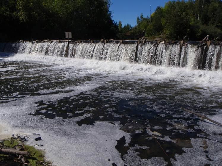
The Hearts Desire Weir is a low-head inline structure operated seasonally on the Jock River between two communities, Hearts Desire and Stonebridge. The Jock River is a tributary river to the Rideau River located about 900 m downstream of the weir. The weir was constructed in 1975 to: provide higher summer flows and thereby improve habitat conditions for fish and wildlife; ensure adequate water for livestock watering; provide community ponds for fire protection and community beautification; and improve the year-round appearance of the river and lessen the likelihood of future pollution problems resulting from expanding urbanization.
Over the last 42 years, a great deal about the watercourse and its neighbouring communities has changed, including:
- concepts on how rivers and watersheds are managed,
- occupational health and safety risks associated with the annual installation and removal of the weir,
- concerns from local community groups about slope failures and erosion upstream of the weir; and,
- indications from whitewater enthusiasts that the weir site is considered to be hazardous by canoeists and kayakers.
In February 2008, the RVCA Board of Directors approved the development of a plan to decommission the Hearts Desire Weir. In response to public input, a restoration plan for the Jock River and its riverbank was also initiated. The decommissioning plan and restoration plan is now in draft form and ready for public input.
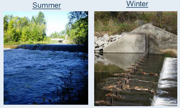
The RVCA is committed to maintaining the current operation of the weir until such a time that the Board of Directors chooses an alternative.
For more information, contact Terry Davidson at or 613-692-3571 ext. 1107 or Mike Yee at or ext. 1176.
Resources
Shoreline Property Owner Package, November 2013
- Hearts Desire Weir Decommissioning and Riparian Restoration Plan Protocol
- Landowner Contact — Shoreline Site Visits
- Landowner Contact Surveying of Estimated Water Levels
Hearts Desire Riparian Restoration Concept Report, October 2011
hd-Riparian_Restoration_PlanFINAL.pdf
Appendix I: Community Representatives Meeting Minutes - September 2010 and Open House Meeting Notes - December 2010
Parish Geomorphic Hydraulic Modeling Technical Report, July 2011(11 mb)
J.L. Richards and Associates Ltd. Jock River Conservation Study, June 1968