

Super User
Ottawa Greek Fest goes carbon neutral!
Aug. 15, 2019 – Ottawa Greek Fest is one of the capital’s hottest summer festivals, but this year it’s keeping it cool with a pledge to go carbon neutral through the Rideau Valley Conservation Foundation.
The charitable foundation helped the festival calculate its estimated carbon footprint from the gas, propane, diesel and electricity used over the course of its 11-day food, music and art extravaganza at the Hellenic Centre near Hog’s Back Falls. That calculation will translate into 120 trees planted locally across the Rideau Valley watershed, adding to Eastern Ontario’s forests and natural spaces and offsetting the event’s carbon footprint over the next 40 years.
So, how does planting trees make a festival like GreekFest carbon neutral? Trees absorb carbon dioxide from the air and capture it in their wood cells as part of their life cycle. Once we know how much carbon an event creates, we know how many trees are needed to offset it. It’s as easy as that!
The foundation supports the watershed protection work of the Rideau Valley Conservation Authority. Its staff plant and care for the trees over time to make sure they grow into a thriving forest that will not only capture carbon but also reduce runoff and flood risks, create vital wildlife habitat and improve soil quality.
Want to make your own home, business or event carbon neutral? Visit our website for more information: https://www.rvcf.ca/ways-to-give/carbon-neutral-program.
To support Ottawa’s latest carbon neutral event, visit www.ottawagreekfest.com.
-end-
Minor Low Water Conditions in Rideau Valley Watershed

August 15, 2019 — As the warm, dry weather continues, conditions in the Rideau Valley Watershed now meet the threshold for Minor Low Water status under the Ontario Low Water Response Program. Watershed residents and businesses are encouraged to conserve water during dry conditions.
After a cool and wet spring with very significant flooding in some areas, July and August have been mostly warm and dry across the Rideau Valley watershed, with some localized rainfall in early August. The average 90-day rainfall measured at climate stations in and around the watershed is just shy of 80 per cent of normal for this time of year, which is a key indicator for Minor Low Water status. In the past 30 days, average rainfall has been about 40 per cent of normal. Looking ahead, the seven-day weather forecasts suggests we’ll continue to experience above average temperatures and minimal precipitation, and conditions are expected to decline.
For the most part, water levels in lakes and rivers are close to normal for this time of year. However, we expect water levels will start to decline more noticeably in the near future. Outflows from the Rideau Canal’s reservoir lakes have recently been increased to compensate for the water level declines in river reaches downstream, including the Tay River and Big Rideau Lake. However, there is still sufficient water for Parks Canada to state that draft and navigation are normal throughout the Rideau Canal system inside the Rideau Valley watershed.
Conservation Authority staff continue to monitor conditions and communicate with water managers throughout the watershed. Updates to this message will be issued as conditions warrant.
More resources:
Ministry of Environment and Climate Change: https://www.ontario.ca/page/managing-your-water-well-times-water-shortage
Ontario’s Low Water Response program: https://www.ontario.ca/page/low-water-response-program.
RVCA website: www.rvca.ca
Hourly and daily streamflows and water levels: https://www.rvca.ca/watershed-monitoring-reporting/reporting/streamflow-water-levels
Fight the invaders! Free workshop taking aim at invasive species
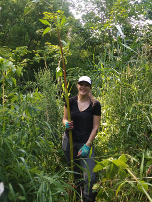
Aug. 14, 2019 – Did you know? Your beautiful backyard garden could be harbouring dangerous enemy invaders: sneaky, ruthless agents of destruction, ready to launch a coup at any opportunity.
We’re talking, of course, about invasive species.
They can be hard to spot – sometimes distracting you with their gorgeous blooms or glittery shells – but a workshop this weekend can help you identify these interlopers and keep them under control.
From 9 a.m. to 12 p.m. on Saturday, Aug. 17, Rideau Valley staff will lead a free, public workshop at the conservation authority’s headquarters in Manotick. Participants can get up close and personal with several live displays while they learn about the types of invasive species found in Eastern Ontario, how they spread and how to identify them. Famous examples in Ottawa include the emerald ash borer, purple loosestrife and the round goby – to name just a few.
Invasive species aren’t native to the local ecosystem, so they have few natural predators and can out-compete their native counterparts for food and habitat. They spread quickly along walking trails by way of shoes and strollers, in the water by boats and other vehicles, and by gardeners who don’t realize the beautiful Himalayan Balsam they just planted could quickly hop the fence and take over a nearby shoreline.
On top of their environmental damage, invasive species can also cause problems for humans. Invasive wild parsnip and giant hogweed can cause severe burns and rashes, for example, while zebra mussels have clogged equipment all along the Rideau Canal.
To participate, RSVP to . Light refreshments will be served.
What: Invasive Species Identification Workshop
When: Sat. Aug. 17, 9 a.m. to 12 p.m.
Where: RVCA headquarters
3889 Rideau Valley Dr.
Manotick, ON
K4M 1A5
Parking: There is ample parking at the main office.
-end-
Wildlife reclaiming restored wetlands near DND campus
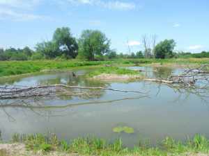
August 7, 2019 —You know what they say: "If you build it, they will come." But that old adage isn't just for haunted baseball fields – it also applies to wetland projects right in the heart of Ottawa's greenbelt.
Last fall, staff at the RVCA and the National Capital Commission created 10,000 square metres of new wetland habitat along Stillwater Creek, just south of the new DND headquarters off Moodie Drive and Highway 417.
Thanks to observations from the Ottawa-Carleton Wildlife Centre, which is located nearby, staff at the NCC and RVCA discovered the wetland had been suffering annually from extreme low water conditions. Most of the year the wetland was completely dry, dominated by long, reedy grasses that don't encourage much biodiversity.
Now, the restored wetland areas have been reconnected to the groundwater system and feature three large, permanent ponds of varying depths, with logs and branches for fish and wildlife habitat and a range of native wetland plants.
The transformation has been nothing short of miraculous: in just one season, RVCA biologists and field staff have witnessed a huge comeback for frogs, birds and fish.
Staff have spied a spotted sandpiper, nesting killdeer and a yellow warbler. Frogs have moved in and will likely stay the winter. And they've found a wide variety of fish in the new habitat, including pearl dace, brown bullhead and blacknose shiners.
"This project was about improving the hydrology and the function of the wetland, but when you do that the ecological functions inevitably improve, too," said RVCA aquatic biologist Jennifer Lamoureux, who designed the wetland features.
The work isn't quite finished. This fall, staff and volunteers will harvest cuttings from nearby dogwood and willow shrubs and will stake them around the wetlands to encourage growth of the plants, which will provide shade and important shoreline habitat.
Funding permitting, staff hope to continue monitoring the health of the new wetland over the next five years as plants take root and more wildlife begins to call it home.
Residents can watch the progress for themselves: walking trails are already present all around the wetland, connecting to the Watts Creek pathway off Corkstown Road.
Check it out this summer!
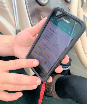
July 29, 2019 – Custom-built smartphone apps are changing the way staff at Rideau Valley Conservation Authority get their work done – and saving time, money and headaches in the process.
This spring, the RVCA launched its latest app, this one for classifying shorelines – something no other conservation group is doing digitally.
Gone are the bulky clipboards and windswept papers of previous surveys. And vanquished are the days of tedious data entry after a long season on the water.
These days, with the tap of an app staff can quickly analyze a shoreline, take a photo and input all the relevant data into a digital database, all from the palm of their hand – and from the middle of a river.
"It's amazing," said Adrienne Lewis, an aquatic resource technician with RVCA for the past 11 years. "It's fast and easy. We don't even have to label our photos, because we take them inside the app. We've eliminated 40 to 60 pieces of paper each day."
In-house GIS/database specialist Chris Czerwinski took the survey's old paper field form and turned it into a custom-made digital data chart using the platform Survey123.
This summer, as Adrienne heads down the river with a student by her side, she assesses shoreline conditions from her smartphone, ticking boxes in the app to make note of erosion, invasive species, vegetation and other factors that contribute to water quality and shoreline health.
The data is uploaded to the cloud, offering real-time results from the field and eliminating the need for manual data entry – and reducing the opportunity for human errors by half. The data is then easily formatted to inform RVCA programs and decisions.
It's a huge time savings.
"We've taken the workflow from the field and emulated that in the app," Chris said. "This survey project was supposed to take two years and they're going to finish it in one season. That speaks to the efficiency of the new process."
The RVCA has come a long way in a short time when it comes to tech.
"I built the RVCA's first app in 2013, and it was fairly novel at the time," Chris said.
But by today's standards, that first app is downright quaint: it ran on a GPS-equipped handheld device that could run a Windows operating system that's no longer even supported.
Since then, the RVCA has developed five different mobile apps to improve workflow in the field, assisting staff with water quality monitoring, aquatic insects sampling, shoreline classification, septic re-inspection, and forestry site visits.
"Ten years ago, everything was done on paper," Chris said. "Now, the amount of technology we use is amazing. It has exponentially driven workflows up."
The demand for mobile app solutions is so great, he's having to manage staff expectations: there's only so much that can be developed at once.
"Staff always want more, because they can see the benefits," he said. "There's so much more to come."
Collaboration is key
Conservation authorities across the province are all taking up the tech trend, developing apps for all manner of monitoring and tracking programs they run every day to promote healthy watersheds.
And with tight budgets and stretched staff, sharing has been caring. A key benefit of the new technology is the ability to share workflows with other conservation authorities and environmental groups. Chris shares what he creates and borrows from others. This saves time and effort for all the groups, because no one's reinventing the wheel.
This winter, for example, Chris will borrow the bones of a snowpack measuring app developed by Quinte Conservation and tweak it to suit the RVCA's needs – no need to create his own.
It's especially easy to collaborate when the apps are for monitoring programs that follow international, national or provincial data collection protocols. If everyone's following the same process with the same data criteria, a customized app can be used by any protocol partner, Chris said.
And the potential for new apps and digital solutions is endless.
"When I think where we'll be in five years, it's incredible," Chris said.
-end-
Mud Creek Flood Risk Mapping Study, July 2019
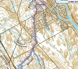
Mud Creek Hazard Mapping Study
Project Status: Complete
The Rideau Valley Conservation Authority (RVCA) has completed a hazard mapping study for Mud Creek from 3rd Line Road North to the Rideau River.
These maps have been traditionally known as “floodplain mapping” or “regulation mapping” and they show areas that are prone to natural hazards such as flooding, erosion and natural environment features such as wetlands.
When completed, the mapping will be used by the City of Ottawa when updating their Official Plan and Zoning Schedules and in the review of development applications under the Planning Act. RVCA will also use the mapping to guide the review of development applications submitted under the Development, Interference with Wetlands and Alterations to Shorelines and Watercourses Regulation.
Members of the public are encouraged to attend the upcoming open house (details below) and/or provide comments on the draft mapping (see below). Conservation Authority staff welcome historical records of past flood events, slope failure, erosion, news clippings, photographs and even anecdotal stories to help confirm the reasonableness of calculations and resulting hazard mapping For those unable to attend the open house, comments can be sent to Ferdous Ahmed, RVCA Senior Water Resources Engineer at .
These mapping studies are being completed as part of the City of Ottawa Hazard Mapping Project.
Mud Creek Report
Report: Mud Creek Flood Risk Mapping from Prince of Wales Drive to Rideau River, July 9, 2019
These studies are being done through a collaboration — known as the City of Ottawa Hazard Mapping Project — involving the City of Ottawa and the Mississippi Valley, Rideau Valley and South Nation Conservation Authorities. The City recognized a need to update its zoning schedules based on up-to-date flood risk mapping and has provided contributions enabling the Conservation Authorities to move ahead with these studies sooner than would otherwise be possible. The RVCA is currently working on several studies in the Ottawa area.
Stay safe this summer: stay on the trails!
July 19, 2019 – It’s a great time to be outdoors, but be aware: certain pests and poisonous plants are getting in on the action, too.
As you hit the trails, remember to stay on the path and dress appropriately to protect against ticks, poison ivy, wild parsnip and other hazards.
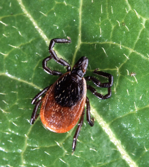
Ticks:
Black-legged ticks are on the rise in Eastern Ontario and can carry Lyme disease, which is passed to humans through tick bites. Left untreated, Lyme can cause chronic neurological and physical problems including memory loss, mobility issues and heart conditions.
But don’t let that keep you inside! Reasonable precautions should prevent most tick bites. When you’re in the woods, stay on the path, wear long pants and sleeves, tuck your pants into your socks and use bug spray with DEET or picaridin. A quick sweep of your clothes with a sticky lint roller before you go home will help catch errant ticks. When you get home, do a thorough tick check of your entire body, including in your armpits, groin area, behind your ears and along hairlines.
If you do find a tick attached, remove it as soon as possible. Contact your doctor if the tick looks engorged or you think has been attached for a long time, to see if you need antibiotics.
If the tick was attached for less than 24 hours and its body does not appear swollen from feeding, you should still be on the lookout for signs and symptoms of Lyme disease for the next 32 days. If you do develop symptoms, see a doctor.
Poisonous plants:
Poison ivy, wild parsnip and giant hogweed all have a presence in Eastern Ontario, lining roadside ditches, taking over empty fields and popping up along nature trails and woodlots.
Touching these plants or their sap can result in painful skin rashes and burns, particularly wild parsnip, which is sun-activated and can cause severe burns and even blindness in extreme cases.
Wear long pants and sleeves, close-toed shoes and socks. The sap from these plants can contaminate your clothes, so be careful when undressing and handling your clothes after an outing.
If you do come in contact with the plants, wash the area with soapy water and stay out of the sun. If the sap gets in your eyes, wash immediately and contact a doctor.
Of course, it’s important to know what to look for so you can avoid these issues altogether.
Poison ivy is perhaps the best known of the three plants. It can grow between 10 and 80 centimetres high, and its leaves range from 8 to 55 millimetres long. Poison ivy leaves feature three pointed leaflets – usually toothed – with the middle leaf being much longer. The leaves are reddish in the spring, turn green in the summer, and become various shades of yellow, orange, or red in the fall. The plant produces clusters of cream to yellow-green flowers.
Wild parsnip can grow up to 1.5 metres tall, with a thick, smooth stem topped with green-yellow flowers forming clusters up to 20 centimetres across.
Giant hogweed looks similar to wild parsnip but grows up to five metres tall in some cases. Its white flowers are clustered in groups between 30 and 90 centimetres across, and its thick stem often features prominent purple blotches.
Remember: There’s so much to see and do in the Rideau Valley watershed – don’t let these spoilsports get in your way! Take precautions, stay on the path and, most importantly, have fun.
-end-