Super User
AUGUST 20, 2018, RIDEAU VALLEY AND MISSISSIPPI VALLEY WATERSHEDS – The Mississippi-Rideau Source Protection Committee wants your input on their Draft Amendment for the Rideau Valley Source Protection Area Assessment Report and Source Protection Plan (prepared under Ontario’s Clean Water Act).
The Draft Amendment for the Assessment Report identifies:
- A new wellhead protection area for the new municipal well system for the Western Development Lands in Richmond
- Revised wellhead protection areas for the existing municipal well systems in King’s Park Richmond and Munster
- Potential drinking water threats in the new and existing wellhead protection areas
The Draft Amendment for the Source Protection Plan does not include any policy changes but rather simple updates to reflect the addition of new or revised wellhead protection areas in Munster and Richmond, including updated maps and schedules.
There are several ways to view the Draft Amendment:
Visit the Mississippi-Rideau Source Protection Region’s website:
Visit either of the Conservation Authority Offices:
- Mississippi Valley Conservation Authority, 10970 Hwy. 7 Carleton Place from 8:00 a.m. to 4:00 p.m. weekdays
- Rideau Valley Conservation Authority, 3889 Rideau Valley Drive, Manotick from 8:30 a.m. to 4:30 p.m. weekdays
Contact Tessa Di Iorio at the City of Ottawa at 613-582-2424 ext. 17658 to schedule a viewing appointment at:
- North Gower Client Service Centre, 2155 Rogers Stevens Drive, North Gower
- Laurier Client Service Centre, 110 Laurier Avenue West, Ottawa
For more information or to provide comments, please contact: Brian Stratton, Project Manager
Mississippi-Rideau Source Protection Region
3889 Rideau Valley Drive, PO Box 599, Manotick, ON K4M 1A5
613-692-3571 or 1-800-267-3504 ext. 1141
All comments must be received no later than Friday, September 28, 2018.

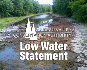
August 20, 2018 – This statement is to advise that the low water status in the Rideau River watershed generally remains at “Minor” Severity except for the Kemptville Creek sub-watershed which has risen to “Moderate” Severity.
Rainfall in eastern Ontario has been widely varied since late July. What rain that has fallen in the Kemptville Creek sub-watershed has had little effect on flows with much of it infiltrating into the soil and retained in wetlands. The Creek is down to intermittent pools in some sections. Beaver have been active, building dams that contribute to the ponding. At the same time, they are creating pools upstream of their dams they are causing or expanding dry sections downstream. The ponding on Kemptville Creek and other streams has left fish and other aquatic populations to cope with confined spaces, warmer water and declining oxygen concentrations.
Conditions in the rest of the Rideau watershed are closer to “Minor” Severity which has been in place for the last two weeks. Much less rain than was forecast fell on Thursday and Friday last week. Water levels continue to decline and all monitoring stations are showing levels below average. Rain is forecast for tomorrow but, with weather systems as erratic as they have been, it remains to be seen how significant an impact there will be.
The Rideau Canal reservoir lakes all continue to have levels below normal. Sufficient draft is still available for boats on the system but caution is advised. Other lakes have also had falling water levels and aquatic plants and algae are thriving on some due to the warm temperatures and shallower depths.
Longer range forecasts indicate warmer and dryer conditions than normal through the rest of the summer and into the fall. If that forecast comes to pass, flows and levels can be expected to fall well below normal.
Water conservation should be practiced by everyone within the Rideau River watershed. Various actions all contribute to the conservation of our water resources. Municipalities may have invoked water restrictions and burn bans so check your municipal website for applicable bylaws. Those who have permits for taking water from surface or groundwater sources are encouraged to reduce their actual taking as much as possible.
Conservation Authority staff continue to monitor conditions and communicate with water managers throughout the watershed. Updates to this message will be issued as conditions warrant.
Other relevant information sources are:
Ministry of Environment and Climate Change: https://www.ontario.ca/page/managing-your-water-well-times-water-shortage
Ontario’s Low Water Response program: https://www.ontario.ca/page/low-water-response-program.
RVCA website: www.rvca.ca
Hourly and daily streamflows and water levels: https://www.rvca.ca/watershed-monitoring-reporting/reporting/streamflow-water-levels .
Watershed Discovery Day
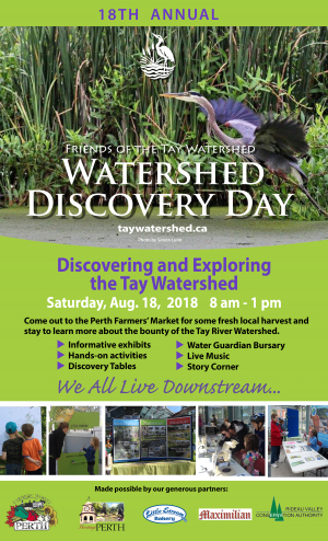
TAY WATERSHED — Discover and explore the Tay Watershed at the Friends of the Tay Watershed's 18th Annual Watershed Discovery Day. The event takes place on Saturday, August 18 from 8 a.m. to 1 p.m. at the Perth Farmers' Market.
For full details click here.
Convert Marginal Land or Abandoned Farm Fields into Thriving Forests – For a Couple Dimes A Tree
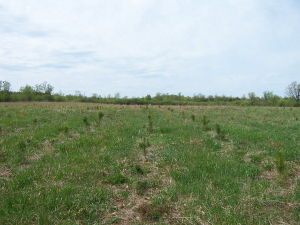
OTTAWA WEST and RIDEAU WATERSHED — If you have marginal land or abandoned farm fields, now is the time to take advantage of significant subsidies to covert the land to forests.
“Many landowners are choosing to make their land more productive and enjoyable by planting trees,” says Scott Danford, Rideau Valley Conservation Authority (RVCA) Forestry Program Manager. “There are significant subsidies available to help landowners plan, prepare and plant their forests. Planting two acres will cost landowners less than $300.”
Typical costs for the RVCA’s full-service tree-planting program are $0.15/tree ($120/acre). The RVCA and its planting partners covers all additional costs. Landowners interested in having one acre or more (0.4 hectares) planted in trees should meet with RVCA staff to start planning now.
“We have been planting trees since 1983 and have planted more than 6 million trees,” says Danford. “We are committed to helping landowners meet their reforestation needs, while increasing tree cover throughout the Rideau watershed.”
Woodlands can be established in old fields by promoting natural succession, but few landowners have the time or patience for this option. The quicker option is to plant trees through the Conservation Authority’s program. The RVCA’s tree planting program can help move things on a little faster. Professional staff will meet with landowners to discuss their interests and needs. RVCA staff will also inspect the site’s conditions to help create a unique, individualized planting plan. The types of trees being planted will reflect the needs of the landowner and the site conditions — the goal being to plant the right tree in the right place to get the best chance of survival and growth.
Now is the time to book your free site visit by contacting Scott Danford, RVCA Forestry Program Manager at 613-692-3571 or 1-800-387-5304, ext. 1175.

August 2, 2018 – This statement is to advise that the low water status in the Rideau River watershed has been reduced to Minor Severity.
Longer range forecasts indicate warmer and dryer than normal through the rest of the summer and into the fall. If that forecast comes to pass, flows and levels can be expected to fall well below normal. Present conditions are generally close to normal but because of declining flows and forecasts, the low water status is being reduced from Moderate to Minor Severity rather than being withdrawn entirely.
Record rainfall was measured at several climate monitoring stations in eastern Ontario through July 21 – 28. Forecast amounts were exceeded throughout the Rideau watershed. The result was streamflows above the historical averages for the time of year in most cases.
However, flows are declining again and can be expected to descend below average once more with limited rain forecast and days with 30 degree temperatures causing evaporation. Except for Bobs Lake, the Rideau Canal reservoir lakes are 10 to 20 centimetres below targets at levels scheduled to be reached by late September. Bobs Lake, presently about 10 cm below the rule curve, is at levels expected to be reached by a week and a half into August. A better indicator may be the long term historical averages which reflect how difficult it is to maintain lake levels to a prescribed elevation. This summer, levels on all of the reservoir lakes have been typically below the historical average.
Kemptville Creek has responded little to the rainfall. Smaller tributary streams are again going dry after brief increases. The Creek itself has flows about 6% of normal measured downstream of Oxford Mills compared to, for example, the Jock River at twice normal for the time of year. With such flows that are occurring in the Kemptville Creek sub-watershed, habitat for fish and other aquatic creatures is diminished and populations are likely to be affected.
The full impact on agriculture of the kind of conditions presently being experienced in the Rideau watershed is never known until the crops are harvested. How well each crop does depends entirely on timing and quantity of rain and heating temperatures.
Water conservation should be practiced by everyone within the Rideau River watershed. Use of rain barrels to capture water for lawns and gardens, avoiding using pressure washers to clean houses, driveways, decks and fences are actions that contribute to the conservation of our water resources. Municipalities may have invoked water restrictions so check your municipal website for applicable bylaws. Those who have permits for taking water from surface or groundwater sources are encouraged to reduce their actual taking as much as possible.
Conservation Authority staff continue to monitor conditions and communicate with water managers throughout the watershed. Updates to this message will be issued as conditions warrant.
Other relevant information sources are:
Ministry of Environment and Climate Change: https://www.ontario.ca/page/managing-your-water-well-times-water-shortage
Ontario’s Low Water Response program: https://www.ontario.ca/page/low-water-response-program.
RVCA website: www.rvca.ca
Hourly and daily streamflows and water levels: https://www.rvca.ca/watershed-monitoring-reporting/reporting/streamflow-water-levels .
This statement is to advise that the low water status in the Rideau River watershed has been reduced to Minor Severity.
Longer range forecasts indicate warmer and dryer than normal through the rest of the summer and into the fall. If that forecast comes to pass, flows and levels can be expected to fall well below normal. Present conditions are generally close to normal but because of declining flows and forecasts, the low water status is being reduced from Moderate to Minor Severity rather than being withdrawn entirely.
Record rainfall was measured at several climate monitoring stations in eastern Ontario through July 21 – 28. Forecast amounts were exceeded throughout the Rideau watershed. The result was streamflows above the historical averages for the time of year in most cases.
However, flows are declining again and can be expected to descend below average once more with limited rain forecast and days with 30 degree temperatures causing evaporation. Except for Bobs Lake, the Rideau Canal reservoir lakes are 10 to 20 centimetres below targets at levels scheduled to be reached by late September. Bobs Lake, presently about 10 cm below the rule curve, is at levels expected to be reached by a week and a half into August. A better indicator may be the long term historical averages which reflect how difficult it is to maintain lake levels to a prescribed elevation. This summer, levels on all of the reservoir lakes have been typically below the historical average.
Kemptville Creek has responded little to the rainfall. Smaller tributary streams are again going dry after brief increases. The Creek itself has flows about 6% of normal measured downstream of Oxford Mills compared to, for example, the Jock River at twice normal for the time of year. With such flows that are occurring in the Kemptville Creek sub-watershed, habitat for fish and other aquatic creatures is diminished and populations are likely to be affected.
The full impact on agriculture of the kind of conditions presently being experienced in the Rideau watershed is never known until the crops are harvested. How well each crop does depends entirely on timing and quantity of rain and heating temperatures.
Water conservation should be practiced by everyone within the Rideau River watershed. Use of rain barrels to capture water for lawns and gardens, avoiding using pressure washers to clean houses, driveways, decks and fences are actions that contribute to the conservation of our water resources. Municipalities may have invoked water restrictions so check your municipal website for applicable bylaws. Those who have permits for taking water from surface or groundwater sources are encouraged to reduce their actual taking as much as possible.
Conservation Authority staff continue to monitor conditions and communicate with water managers throughout the watershed. Updates to this message will be issued as conditions warrant.
Other relevant information sources are:
Ministry of Environment and Climate Change: https://www.ontario.ca/page/managing-your-water-well-times-water-shortage
Ontario’s Low Water Response program: https://www.ontario.ca/page/low-water-response-program.
RVCA website: www.rvca.ca
Hourly and daily streamflows and water levels: https://www.rvca.ca/watershed-monitoring-reporting/reporting/streamflow-water-levels .

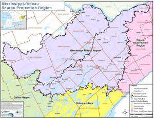
MISSISSIPPI AND RIDEAU WATERSHEDS — The Mississippi-Rideau Source Protection Region (MRSPR) is seeking Source Protection Committee members who are interested in protecting municipal drinking water sources in the Mississippi and Rideau Valley watersheds.
The MRSPR Committee was established in 2007 as a result of the Province’s Clean Water Act. The committee guides local efforts to protect drinking water at the source and is made up of one-third municipal, one-third economic and one-third public sector representatives. The composition ensures that a variety of local interests are represented at the decision-making table as the committee works to oversee the implementation of science-based source protection plans.
The committee is currently undergoing a renewal to ensure that it remains in compliance with Ontario Regulation 288/07, the regulation that governs Source Protection Committees under Ontario’s Clean Water Act. The committee is looking for two economic sector representatives to liaise on behalf of industrial, commercial or small business interests as well as two public sector representatives to liaise on behalf of general public, environmental, First Nations and non-governmental organization interests.
“If you have experience and knowledge in one of these two sectors and have an interest in protecting drinking water sources we hope you will apply,” said Brian Stratton, Mississippi-Rideau Source Water Protection Project Manager. “Among other qualifications, these positions require a multi-year commitment, an ability to understand scientific and technical reports and attendance at the two or more Source Protection Committee meetings held each year. Applicants must also live or work in the Mississippi and Rideau watersheds.”
Future work of the Committee includes the review of new scientific and technical information to ensure that the Source Protection Plan and its supporting reports remain current and relevant.
Further details regarding these part-time positions including descriptions of roles and responsibilities and an application form are available online at https://www.mrsourcewater.ca/en/source-protection-committee-member-recruitment. A small per diem as well as expenses (mileage and meals) will be paid while working on Source Protection business.
Applications are being accepted until August 27, 2018.
TAY SUBWATERSHED, July 24, 2018 — Thanks to special funding through the Great Lakes Guardian Community Fund, the Rideau Valley Conservation Authority (RVCA) is covering costs for shoreline restoration projects to landowners in the Tay Subwatershed.
Landowners whose land drains into the Tay River or one of its 14 catchments (portions of Central Frontenac, Drummond/North Elmsley, Rideau Lakes, South Frontenac and Tay Valley Townships) could be eligible for full cost coverage for shoreline naturalization planting and partial funding for tree planting and livestock restriction fencing projects.
RVCA and the Rideau Valley Conservation Foundation were awarded $25,000 by the Great Lakes Guardian Community Fund for environmental work specifically located in the Tay River Subwatershed. This special provincial fund supports work that protects and restores ecological health to the Great Lakes and St. Lawrence River Basin. The money will go towards stewardship activities that will improve watershed health and water quality.
“The RVCA is always looking to work with landowners and businesses who want to help improve water quality,” says Meaghan McDonald. “We do this by undertaking what’s known as best management practices — which are basically simple, practical and affordable ways to manage our resources and let nature do her job on our behalf.”
Unaware of the importance of shoreline vegetation, many landowners clear their shorelines and transform them into urban landscapes. They destroy the cattails, bulrushes and other native species. These changes destroy the balance of the aquatic and shoreline ecosystem. They also alter the wildlife habitat, natural beauty and character of our lakes and rivers. The clean water and features that landowners valued in their waterfront property are compromised.
Fortunately, degraded shorelines can be restored. More and more cottagers and landowners understand the value of natural shorelines.
Tree planting and shoreline naturalization are two easy ways to reduce erosion, filter pollutants and provide valuable habitat to local species. Fencing and restricting livestock from accessing watercourses also protects the shoreline, reduces erosion and keeps animal waste from directly entering creeks, streams and rivers.
“Our goal is to plant at least 5,000 native trees and 1,000 shrubs to naturalize 1,000 metres of shoreline as part of this special project, says Ms. McDonald. “We also hope to work with local farmers and see an additional 300 metres of fencing installed to reduce livestock access to watercourses.”
RVCA staff are looking to connect with interested landowners and conduct site visits and prepare project plans in the coming few months. Fencing projects can be undertaken at any time, but planting projects are being planned now for completion in spring of 2019.
“The success of the program relies largely on landowner interest,” says Ms. McDonald. “We really hope to work with landowners and balance their needs with the needs of the environment. Making the shoreline program free will hopefully enhance participation.”
The project is well supported locally, with participation from community groups including the Friends of the Tay Watershed and Bobs & Crowe Lake Foundation/Association.
“Everyone here wants the same thing,” says Ms. McDonald. “A clean, healthy waterway supporting a vibrant, sustainable community. Working together we hope to maintain and protect the Tay River system.”
To learn more or get involved, contact Meaghan at ext. 1192 or . To learn more about the health of the Tay River Subwatershed and what can be done to maintain and improve local conditions, visit watersheds.rvca.ca.