Super User
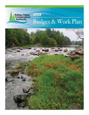
2019 Budget & Work Plan

The Rideau Valley Conservation Authority 2019 Budget & Work Plan is now available. Click here to view it or find it under Annual Work Plans in the Publications section of the website.
RVCA Launches New Logo
November 23, 2018, MANOTICK, ON — The Rideau Valley Conservation Authority (RVCA) is pleased to announce the launch of its new corporate logo. The RVCA revealed its new logo at its November Board of Directors meeting last night. The new streamlined logo reflects a modernized brand while maintaining the RVCA’s deep-rooted history in watershed management.
“We’re excited to update the RVCA brand with a new design that honors our roots and represents our ongoing commitment to the watershed communities we serve,” says Sommer Casgrain-Roberston, RVCA General Manager. “We recently celebrated our 50th anniversary and completed a year-long strategic review. As part of these milestones, we decided an updated logo was a positive and logical next step.”
For over 50 years the RVCA has worked to protect the health of the Rideau Watershed and the people who live in it through environmental monitoring and reporting, on-the-ground restoration and stewardship, conservation lands and education, development review and approval and flood forecasting and warning. The RVCA aims to protect water quality and water supplies, reduce flood risk and erosion hazards, improve habitats and increase conservation lands throughout its 4,234 square kilometre watershed located in eastern Ontario.
The modernized logo reflects the dynamic, fluid organization the RVCA is today but still retains the integrity of the old logo with trees and water as the central visual elements. Colours have been brightened to increase visibility, and the font has been changed to be bolder and more readable.
“This is our first ever logo update since the formation of the RVCA in 1966,” said Ms. Casgrain-Roberston. “The new logo recognizes our past, present and future while adding a modern spirit. We are excited to share it with our watershed residents.”
The new design was created in-house by RVCA Communications staff. The public will likely see both logos in use for some time as current stocks of branded materials are depleted before a full transition to the new look.
Friends of Foley Mountain Invest in Children and Outdoor Education with Purchase of Snowshoes
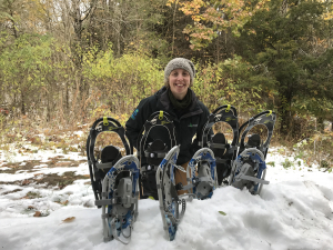
EASTERN ONTARIO, November 19, 2018 — Thanks to the hard work and fundraising efforts of the Friends of Foley Mountain, hundreds of students will be able to experience the wonder of Foley Mountain trails by snowshoe this winter. Forty-four new pairs of snowshoes arrived at the Conservation Area last week, just in time for winter programing.
Foley Mountain Conservation Area, owned and operated by the Rideau Valley Conservation Authority (RVCA), welcomes over 2,500 students annually to learn about nature and their local environment. Winter programing has traditionally included the opportunity for students to experience one of the oldest forms of transportation in Canada. Students learn how to safely travel with snowshoes and, once comfortable, follow the snowshoe trail through the forest and try snowshoe games.
“Our snowshoe program has been very popular — which is amazing! But it means we need more shoes or have to replace worn equipment to accommodate the demand,” said Rebecca Whitman, Foley Mountain Area Supervisor and Outdoor Educator. “We are delighted to have partners like the Friends of Foley Mountain and Trailhead Kingston who want to help us maintain our programs and keep programs accessible to schools and students from Eastern Ontario.”
“The Friends of Foley Mountain are pleased to help make education programing at Foley Mountain more accessible to the communities it serves,” Rob Struthers, President of Friends of Foley Mountain. “We look to support actions that remove barriers and help more people get out into nature — through accessible trails, low program cost and special busing subsidies, supporting new program development like the Foley Mountain Forest School, and now, an increase in equipment. Children are our future and deserve our investments. It is with pride that the Friends of Foley Mountain continue to support RVCA in its education programs”
Foley Mountain’s snowshoe experience opens the door to an amazing winter learning for local students. Not only do these snowshoes allows classes to access the forest for outdoor learning, it also introduces students to a wonderful recreational activity. Snowshoes provide a great fitness and recreation option for the winter season.
Students learn snowshoeing techniques and trail etiquette along with important safety tips. Once comfortable, students follow the snowshoe trail to experience a winter wonderland of rugged Canadian Shield, hardwood forests, old growth white pine and yellow birch. And you never know what you may spy when out on the trails with one of Foley Mountain’s expert outdoor educators.
“Without the ongoing commitment from the Friends of Foley Mountain, we couldn’t work towards our goal of fostering a lifelong relationship between children and the natural world,” said Mrs. Whitman. “Thanks to the Friends, local youth can experience a wonderful adventure and learn best by doing.”
To learn more about the Friends of Foley Mountain and their fundraising initiatives, visit www.friendsoffoley.ca. To learn more about outdoor experiences at Foley Mountain Conservation Areas, visit www.rvca.ca.
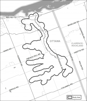
CITY OF OTTAWA, November 14, 2018 — The Rideau Valley Conservation Authority (RVCA) has completed a hazard mapping study for Becketts Creek from the Sarsfield Road to Ottawa River. Members of the public are invited to an upcoming open house to review regulation and hazard maps.
The new mapping shows areas that are subject to natural hazards such as flooding and unstable slopes and have natural environmental features such as wetlands. The mapping will be used by the City of Ottawa when updating its Official Plans and Zoning Schedules and in the review of development applications under the Planning Act. RVCA will also use the mapping to guide the review of development applications submitted under the RVCA’s Development, Interference with Wetlands and Alterations to Shorelines and Watercourses Regulation.
The goal of this mapping is to help ensure that sound planning decisions are made — keeping people and property safe. Accurate engineered hazard mapping is the foundation of effective floodplain and resource management.
Members of the public are encouraged to attend the open house and/or provide comments on the mapping. Conservation Authority staff welcome historical records of past flood events, slopes failures, erosion, news clippings, photographs and even anecdotal stories to help confirm the reasonableness of calculations and resulting hazard mapping.
Becketts Creek Regulations and Hazard Land Mapping Study Public Open House
Tuesday, December 4, 2018
4:30 to 8:00 p.m.
R.J. Kennedy Memorial Community Center, Hall A
1115 Dunning Road, Cumberland
For those unable to attend the open house, mapping can also be seen online at www.rvca.ca/becketts-creek. To understand how mapping may affect your property or to provide comments, please contact an RVCA Resource Specialist at or complete an online property inquiry form at www.rvca.ca/ general-property-inquiries.
This study is being done through a collaboration involving the City of Ottawa and the Rideau Valley, Mississippi Valley and South Nation Conservation Authorities. The City recognized a need to update its zoning schedules based on up-to-date hazard mapping and has provided contributions enabling the Conservation Authorities to move ahead with these studies sooner than would otherwise be possible. The RVCA is currently working on several studies in the Ottawa area. For a complete list on ongoing work, please visit www.rvca.ca.
RVCA By-laws
| File | ||
|---|---|---|
| By-law No. 1—Administrative By-law | Download | |
Becketts Creek Flood Risk Mapping Study, October 2018
Becketts Creek Hazard Mapping Study
Project Status: Complete
The Rideau Valley Conservation Authority (RVCA) has completed a hazard mapping study for Becketts Creek from Sarsfield Road to the Ottawa River.
These maps have been traditionally known as “floodplain mapping” or “regulation mapping” and they show areas that are prone to natural hazards such as flooding, erosion and natural environment features such as wetlands.
When completed, the mapping will be used by the City of Ottawa when updating their Official Plan and Zoning Schedules and in the review of development applications under the Planning Act. RVCA will also use the mapping to guide the review of development applications submitted under the Development, Interference with Wetlands and Alterations to Shorelines and Watercourses Regulation.
Members of the public are encouraged to attend the open house (details below) and/or provide comments on the mapping below. Conservation Authority staff welcome historical records of past flood events, slope failure, erosion, news clippings, photographs and even anecdotal stories to help confirm the reasonableness of calculations and resulting hazard mapping For those unable to attend the open house, comments can be sent to Ferdous Ahmed, RVCA Senior Water Resources Engineer at .
These mapping studies are being completed as part of the City of Ottawa Hazard Mapping Project.
These studies are being done through a collaboration — known as the City of Ottawa Hazard Mapping Project — involving the City of Ottawa and the Mississippi Valley, Rideau Valley and South Nation Conservation Authorities. The City recognized a need to update its zoning schedules based on up-to-date flood risk mapping and has provided contributions enabling the Conservation Authorities to move ahead with these studies sooner than would otherwise be possible. The RVCA is currently working on several studies in the Ottawa area.
Low Water Status Update in Rideau River Watershed
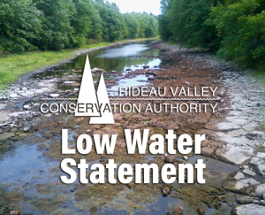
September 27, 2018 – This statement is to advise that the low water status in the Rideau River watershed has returned to “Normal” except for the Kemptville Creek subwatershed which is at “Minor” Severity, down from “Moderate” Severity.
Rain over the last week pushed totals above what is normal for the time of year at most climate monitoring sites in the region. The forecast is indicating more rainfall next week that will begin to restore streamflows to historical averages.
The exception is at the Environment Canada site in Kemptville which has a 90 day total at 67% of normal, well below the threshold for the Minor severity status of 80%.
Winterization of the Rideau Canal will begin on October 9 and proceed to mid-November. Presently, water levels from Ottawa Locks to Newboro are sufficient for navigation. Further information is available on the Parks Canada Infonet (address below).
Water conservation is recommended for all residents of the Rideau River watershed. Burn bans may still be in effect in some municipalities. Check your municipal website for applicable bylaws. Those who have permits for taking water from surface or groundwater sources are encouraged to reduce their actual taking as much as possible.
Conservation Authority staff continue to monitor conditions and communicate with water managers throughout the watershed. Updates to this message will be issued as conditions warrant.
Other relevant information sources are:
Ministry of Environment and Climate Change: https://www.ontario.ca/page/managing-your-water-well-times-water-shortage
Ontario’s Low Water Response program: https://www.ontario.ca/page/low-water-response-program.
Parks Canada Infonet: https://www.pc.gc.ca/en/lhn-nhs/on/rideau/info/infonet/tirant-deau-draft
RVCA website: www.rvca.ca
Hourly and daily streamflows and water levels: https://www.rvca.ca/watershed-monitoring-reporting/reporting/streamflow-water-levels .