Super User
April 3, 2020 (WCS – R06/2020) –The Rideau Valley Conservation Authority is terminating the FLOOD WATCH that was previously in effect and issuing a HIGH WATER SAFETY message for all areas. Water levels and flows are still high for most, but not all, of the larger waterbodies in the Rideau Valley Watershed.
The short-term forecast does not indicate any significant precipitation and the snow is now melted across the Rideau Valley Watershed. As such, water levels and flows are expected to slowly decline in the days ahead.
Everyone needs to be cautious around lakes and streams with the fluctuating water levels. Children need to be educated about the hazards and kept away from all watercourses.
This watershed conditions statement is in effect until April 16, 2020 at 5 PM. No further updates will be issued unless the forecast or conditions change.
-end-
"Rideau Valley Conservation Authority is a partnership of municipalities within the Rideau Valley watershed created under the Conservation Authorities Act to deliver a range of programs in watershed management and natural resource conservation."
RVCA Watershed Conditions Statements:
- Water Safety – High flows, unstable banks, melting ice or other factors that could be dangerous for recreational users such as anglers, canoeists, hikers, children, pets, etc. Flooding is not expected.
- Flood Outlook – Early notice of the potential for flooding based on weather forecasts, calling for heavy rain, snow melt, high winds or other conditions that could lead to high runoff, cause ice jams and/or lakeshore flooding or erosion.
- Flood Watch – Flooding is possible in specific watercourses or municipalities. Municipalities, emergency services and individuals in flood prone areas should prepare.
- Flood Warning – Flooding is imminent or already occurring in specific watercourses or municipalities.
WATER SAFETY STATEMENT — Lower Ottawa River / SÉCURITÉ AQUATIQUE — Cours inférieur de la rivière des Outaouais

March 30, 2020 — A Water Safety Statement is being issued for areas along the Lower Ottawa River. Based on current snow cover and weather forecast, it’s anticipated that levels and flows from Arnprior to Hawkesbury will remain within the normal range of fluctuations associated with the spring freshet period.
The Ottawa River Regulating Committee indicates that with warming temperatures and forecasted precipitation, increases in flows and levels are expected to continue and may cause minor flooding in low-lying areas over the coming weeks depending on the temperatures and precipitation received. Levels are currently expected to remain below flood thresholds.
Throughout the freshet period, the combination of heavy rainfall and snowmelt may result in rapid increases in water levels and flows on the main stem of the Ottawa River from Mattawa down to the Montreal Region.
Residents in flood-prone areas are encouraged to closely follow evolving conditions and to take necessary measures. Residents are advised to stay away from watercourses where flows are high and where banks might be unstable. Parents are encouraged to explain dangers to children.
The Mississippi Valley, Rideau Valley, and South Nation Conservation Authorities monitor water levels and weather forecasts with the Ministry of Natural Resources and Forestry as part of the Flood Forecasting and Warning Program. Updates are provided as conditions change.
The Ottawa River Regulating Committee will be reassessing forecast conditions and providing hydrological condition updates on its website daily at ottawariver.ca/forecasts/.
To view current flood warnings across Ontario, visit: www.ontario.ca/law-and-safety/flood-forecasting-and-warning-program.
This WATER SAFETY STATEMENT is in effect until April 10, 2020 at 5:00 PM.
- end -
Definitions:
- Water Conditions Statement: Water Safety: indicates that high flows, melting ice or other factors could be dangerous for such users as boaters, anglers and swimmers but flooding is
not expected. - Water Conditions Statement: Flood Outlook: gives early notice of the potential for flooding based on weather forecasts calling for heavy rain, snow melt, high winds or other conditions.
- Flood Watch: potential for flooding exists within specific watercourses and municipalities.
- Flood Warning: flooding is imminent or occurring within specific watercourses and municipalities.
Le 30 mars 2020 — Une déclaration de sécurité aquatique est publiée pour les zones situées le long du cours inférieur de la rivière des Outaouais. Selon la couverture de neige actuelle et les prévisions météorologiques, on prévoit que les niveaux et les débits d'eau d'Arnprior à Hawkesbury resteront dans la fourchette normale des fluctuations associées à la période des crues printanières.
Le Comité de régularisation de la rivière des Outaouais indique qu'avec le réchauffement des températures et les précipitations prévues, l'augmentation des débits et des niveaux devrait se poursuivre et pourrait provoquer des inondations mineures dans les zones basses au cours des prochaines semaines, en fonction des températures et des précipitations reçues. Les niveaux devraient actuellement rester en dessous des seuils d'inondation.
Tout au long de la période de crue, la combinaison de fortes précipitations et de la fonte des neiges pourrait entraîner une augmentation rapide des niveaux et des débits sur le cours principal de la rivière des Outaouais, de Mattawa jusqu'à la région de Montréal.
On encourage les résidents des zones inondables à suivre de près l'évolution des conditions et à prendre les mesures nécessaires. Il est conseillé aux résidents de se tenir à l'écart des cours d'eau où les débits sont élevés et où les berges pourraient être instables. On recommande aux parents d'expliquer les dangers aux enfants.
Les offices de protection de la nature des rivières Mississippi, Rideau et Nation Sud surveillent les niveaux d'eau et les prévisions météorologiques avec le ministère des Richesses naturelles et des Forêts dans le cadre du Programme de prévision et d'alerte des crues.
Des mises à jour sont émises en fonction de l'évolution des conditions.
Le Comité de régularisation de la rivière des Outaouais réévaluera les prévisions et publiera quotidiennement des mises à jour des conditions hydrologiques sur son site Web à ottawariver.ca/forecasts/. Pour consulter les alertes de crue actuelles en Ontario, visitez le site : www.ontario.ca/law-and-safety/flood-forecasting-and-warning-program.
Cette DÉCLARATION DE SÉCURITÉ AQUATIQUE est en vigueur jusqu'au 10 avril 2020 à 17 h.
- fin -
Définitions :
- Communiqué sur les conditions des bassins versants – Sécurité aquatique : indique que des débits forts, de la glace fondante ou d’autres facteurs peuvent être dangereux pour des utilisateurs comme les plaisanciers, les pêcheurs à la ligne et les baigneurs, mais qu’une crue n’est pas prévue.
- Communiqué sur les conditions des bassins versants – Perspective de crue :préavis de crue possible basé sur des prévisions de pluies abondantes, de fonte des neiges, de forts vents ou autre.
- Veille de crue :possibilité de crue pour des cours d’eau et municipalités spécifiques.
- Avertissement de crue : crue immimente ou en cours pour des cours d’eau et
municipalités spécifiques.
Updated Flood Outlook & Flood Watch: Rideau Valley Watershed

(WCS – R05/2020) March 27, 2020 –The short-term forecast is calling for rainfall amounts of 35 millimetres or more on Sunday and into Monday with above zero temperatures. As such, water levels and flows across the Rideau Valley Watershed are expected to increase again.
A FLOOD WATCH is being issued for properties around Christie Lake and Wolfe Lake. In these areas, residents should expect freshet like water levels and flows. Parks Canada staff are closely monitoring the water levels in Bobs Lake and Christie Lake, and operations at the Bolingbroke Dam.
A FLOOD WATCH continues for the low-lying areas along Stevens Creek and Taylor Drain in the Village of North Gower; however, water levels are expected to be less than those that have already been seen this spring.
A FLOOD OUTLOOK is being maintained/issued for the following areas:
- Properties around Bob’s Lake and Tay River in the upper Rideau Valley Watershed. In these areas, residents should expect spring like water levels and flows. Parks Canada staff are closely monitoring the water levels in Bobs Lake and Christie Lake, and operations at the Bolingbroke Dam will take place as required, to balance the levels in Bobs Lake and Christie Lake.
- Properties around the Long Reach (Burritts Rapids to Kars) of the Rideau River.
- Properties around the smaller creeks and streams in the lower Rideau Valley Watershed, including the low-lying roads and waterfront properties adjacent to the Jock River (near Richmond).
- Any connected creeks or ditches.
Extreme caution should be exercised by everyone when near local waterbodies. Please note that riverbanks are very slippery at this time of year and it’s quite easy for a child or adult to inadvertently fall into the water. Parents should inform their children of the risks and provide appropriate supervision.
Residents in flood prone or low-lying areas, historically susceptible to flooding, should continue to take the necessary precautions to protect their property, such as:
- Ensuring sump pump is clear, in good working condition and has a backwater valve
- Ensuring easy access to a portable backup generator and pump
- Ensuring downspouts are clear and the outlet is at least 3 metres from the dwelling
- Securing items that might float away as flows increase
- Removing valuable items from basements or lower floors that could be subject to flooding
- Keeping emergency phone numbers handy
- Familiarizing yourself with your municipality’s Emergency Preparedness Plan
This watershed conditions statement is in effect until April 9, 2020, at 5 p.m. and will be updated at that time unless the forecast or conditions change.
"Rideau Valley Conservation Authority is a partnership of municipalities within the Rideau Valley watershed created under the Conservation Authorities Act to deliver a range of programs in watershed management and natural resource conservation."
RVCA Watershed Conditions Statements:
- Water Safety – High flows, unstable banks, melting ice or other factors that could be dangerous for recreational users such as anglers, canoeists, hikers, children, pets, etc. Flooding is not expected.
- Flood Outlook – Early notice of the potential for flooding based on weather forecasts, calling for heavy rain, snow melt, high winds or other conditions that could lead to high runoff, cause ice jams and/or lakeshore flooding or erosion.
- Flood Watch – Flooding is possible in specific watercourses or municipalities. Municipalities, emergency services and individuals in flood prone areas should prepare.
- Flood Warning – Flooding is imminent or already occurring in specific watercourses or municipalities.
Flood Outlook & Updated Flood Watch: Rideau Valley Watershed

(WCS – R04/2020)
March 19 ,2020 – The short-term forecast is calling for rainfall amounts of 10 to 15 mm and high temperatures near 15 degrees Celsius on Friday, followed by below zero temperatures on Saturday, and then milder temperatures in the days following. No significant rain is in the short-term forecast after Friday. With Friday’s rain and high temperatures, water levels and flows across the Rideau Valley Watershed are expected to increase everywhere and then decline again slowly with the cooler weather in the following days.
Some specific areas of concern are highlighted below:
A FLOOD OUTLOOK is being issued for the following areas:
- Properties around Bob’s Lake, Christie Lake and Tay River in the upper Rideau Valley Watershed. In these areas, local residents should expect spring like water levels and flows. Parks Canada staff are closely monitoring the water levels in Bobs Lake and Christie Lake, and operations at the Bolingbroke Dam will take place as required, to balance the levels in Bobs Lake and Christie Lake.
- Properties around Wolfe Lake in the upper Rideau Valley Watershed.
- Properties around the smaller creeks and streams in the lower Rideau Valley Watershed, including the low-lying roads and waterfront properties adjacent to the Jock River (near Richmond)
- and any connected creeks or ditches.
A FLOOD WATCH continues for the low-lying areas along Stevens Creek and Taylor Drain in the Village of North Gower; however, water levels are expected to be somewhat similar or possibly less than those that have already been seen this spring.
Extreme caution should be exercised by everyone when near local waterbodies. Parents should inform their children of the risks and provide appropriate supervision.
Residents in flood prone or low-lying areas, historically susceptible to flooding, should continue to take the necessary precautions to protect their property, such as:
- Ensuring sump pump is clear, in good working condition and has a backwater valve
- Ensuring easy access to a portable backup generator and pump
- Ensuring downspouts are clear and the outlet is at least 3 metres from the dwelling
- Securing items that might float away as flows increase
- Removing valuable items from basements or lower floors that could be subject to flooding
- Keeping emergency phone numbers handy
- Familiarizing yourself with your municipality’s Emergency Preparedness Plan
This watershed conditions statement is in effect until April 2, 2020, at 5 p.m. and will be updated at that time unless the forecast or conditions change.
"Rideau Valley Conservation Authority is a partnership of municipalities within the Rideau Valley watershed created under the Conservation Authorities Act to deliver a range of programs in watershed management and natural resource conservation."
RVCA Watershed Conditions Statements:
- Water Safety – High flows, unstable banks, melting ice or other factors that could be dangerous for recreational users such as anglers, canoeists, hikers, children, pets, etc. Flooding is not expected.
- Flood Outlook – Early notice of the potential for flooding based on weather forecasts, calling for heavy rain, snow melt, high winds or other conditions that could lead to high runoff, cause ice jams and/or lakeshore flooding or erosion.
- Flood Watch – Flooding is possible in specific watercourses or municipalities. Municipalities, emergency services and individuals in flood prone areas should prepare.
- Flood Warning – Flooding is imminent or already occurring in specific watercourses or municipalities.
RVCA Waiving Fees at Local Conservation Areas

Rideau Valley Watershed, March 17, 2020 — RVCA is waiving fees at its Conservation Areas as public health officials encourage people to get out and enjoy a walk during these stressful times. All trails and boardwalks owned and operated by the Rideau Valley Conservation Authority will be open to the public free of charge until April 6, 2020. Interpretive centres and other facilities including washrooms and outhouses will be closed however to protect the health and safety of visitors and staff.
“We recognize that this is a stressful time for people as everyone takes steps to help limit the spread of the Coronavirus” said Sommer Casgrain-Robertson, RVCA General Manager. “We hope that our 11 conservation areas can provide some comfort by offering local residents with a close-to-home outdoor escape where they can enjoy a relaxing walk in a beautiful natural setting”.
Many studies show that time spent in nature reduces stress levels, enhances mental attitude and of course improves physical health. While enjoying our conservation areas we ask that people maintain social distancing and avoid gathering in groups or touching common surfaces.
“We have more than 40 kilometres of trails through mixed hardwood forests, meadows and wetlands,” says Casgrain-Robertson. “We hope families will come and explore our many hiking trails and scenic lookouts especially while schools are closed.”
Conservation Areas in the Rideau watershed include:
- Chapman Mills Conservation Area – Barrhaven/Riverside South
- Baxter Conservation Area – Kars
- Meisel Woods Conservation Area — Crow Lake
- Mill Pond Conservation Area – Portland
- Perth Wildlife Reserve – Perth
- Rideau Ferry Yacht Club Conservation Area – Rideau Ferry
- Foley Mountain Conservation Area – Westport
Visit www.rvca.ca/consevation-areas for a complete listing of locations,
RVCA Offices Closed to Public

Rideau Watershed, March 17, 2020 — The health, safety and well-being of our visitors and staff is our top priority. RVCA is responding to the COVID-19 pandemic with the following changes in operations and programming effective immediately:
- The RVCA Administrative Centre (3889 Rideau Valley Drive, Manotick) is closed to the general public.
- Meetings and events scheduled at the RVCA Administrative Centre are cancelled.
- Education programming and rentals at Baxter and Foley Mountain Conservation Areas are cancelled.
- Interpretive centres and privies at RVCA Conservation Areas are closed to the general public. The trails remain open for physical and mental health benefits and will be available free of charge until April 6, 2020.
- All essential services including RVCA’s flood forecasting and warning operations and planning and permitting remain active.
Staff will continue to provide service over the phone and through email. Please call 613-692-3571 or 1-800-267-3504 or search online at www.rvca.ca/directory for a directory of services and contact information. Permits and other hard copy documents can be dropped off in our drop box at RVCA Administrative office or emailed to the appropriate staff member. Payment can be taken over the phone at 613-692-3571 ext. 1100.
Theses decisions are in response to recent measures implemented across the province. As of today, we plan to reopen on Monday, April 6, 2020. We will continue to monitor the situation and reassess as more information becomes available. Please check the RVCA website and social media platforms for updates. Your patience and cooperation are appreciated.
RVCA’s outdoor facilities at our developed Conservation Area will remain open for public use; only the interpretive centres and privies will be closed. The public are invited to use our outdoor trails and boardwalks free of charge until April 6, 2020. Visit www.rvca.ca/conservation-areas for a complete listing of locations and amenities.
Ottawa Conservation Authorities to Work with Provincial and Municipal Partners on Flooding Strategy

March 12, 2020 — With the spring thaw top of mind for residents who were affected by significant flooding along the Ottawa River in 2019, the Mississippi Valley, Rideau Valley and South Nation Conservation Authorities welcome the coordinated approach that Ontario proposes to build between federal and provincial governments, local municipalities, Conservation Authorities and indigenous partners to protect people and property from the devastating and costly impacts of flooding.
On March 9, 2020, John Yakabuski, the Minister of Natural Resources and Forestry, released Ontario’s Flooding Strategy in response to the Flood Advisor’s 2019 Report, clearly indicating that Conservation Authorities will have a continued role to play in the shared responsibility on strengthening the approach to flooding.
According to Minister Yakabuski in a news release published by the Province on March 9: "We're listening to people from across the province who have been affected by flooding, and that is why we're taking a whole-of-government approach and calling on the federal government, our municipal partners, conservation authorities, industry and Indigenous communities to work with us to implement the actions contained in this strategy."
The Strategy focuses on five priority areas:
- Understanding Flood Riskthrough updated floodplain mapping and increasing access to flood-related information.
- Strengthening Governance through provincial policy to ensure local development is directed away from areas where flooding and erosion present unacceptable risks.
- Enhancing Flood Preparednessusingstate-of-the art science and technology.
- Enhancing Response and Recoveryby improving how we receive and respond to municipal requests for assistance.
- Investing in Flood Risk Reductionby working with the federal government to increase investment in critical areas like mapping and infrastructure.
Ontario’s Flooding Strategy also calls for the update of existing natural hazard technical guidelines used to support municipal and Conservation Authority implementation of flood programs and activities, which was a key request throughout consultations.
“We are pleased to be working with the Province and sharing our flood management expertise and watershed approach to deliver services and programs,” said Sally McIntyre, General Manager, Mississippi Valley Conservation Authority. “We look forward to learning how the Strategy will support sustainable funding for flood forecasting and operations, flood proofing of existing structures and stewardship of wetlands to mitigate flooding.”
“We look forward to enhancing our long-standing partnership with the province,” said Sommer Casgrain-Robertson, General Manager, Rideau Valley Conservation Authority. “Local Conservation Authorities are well-positioned to support the province’s strategy and we will look to better serve our watershed municipalities and residents through our unique watershed approach and our extensive expertise and experience in flood risk management, mitigation
and preparedness.”
“We thank the Provincial Government for highlighting the important role that Conservation Authorities play in understanding flood risk and mitigation within the Ontario Flooding Strategy,” said Angela Coleman, General Manager and Secretary Treasurer, South Nation Conservation. “We look forward to working with all levels of Government to better protect people and property from natural hazards, such as flooding.”
– end —
Winter Work on Hutton Creek Marsh Restoration Complete
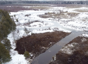
ELIZABETHTOWN-KITLEY, March 11, 2020 – Winter restoration work on the Hutton Creek Marsh is now complete to the delight of the many dedicated partners who made the project possible.
This work completes Phase 2 of a long-term project to bring the provincially significant wetland near Lombardy back to a more natural, productive state. Over the years, the provincially significant wetland located near Lombardy had become a monoculture: choked and overgrown with cattails. Only 10 per cent of the marsh was open water which had negative impacts on its biology, ecology and hydrology.
Hutton Creek Marsh is an amazing sample of Ontario’s provincially significant wetlands. This 300-hectare marsh found upstream of the Motts Mills Berm is part of the much larger Otter Lake - Hutton Creek Wetland Complex which covers 722 hectares. Five individual wetlands make up a palustrine wetland complex, meaning there is a permanent flow of surface water into the wetland from various creeks and out below the Motts Mills Berm into Hutton Creek and on downstream to the Rideau River.
In 2015, the nearby Motts Mills Dam was decommissioned and replaced with an earthen berm. In 2017, the Rideau Valley Conservation Authority (RVCA) lowered local water levels to help staff study the wetland and determine the best way to address the crowded cattails. In 2019, work began to increase the open water features of the marsh. Crews looked to build 1.5 acres of open water ponds and add 500 metres of channels to help return the wetland to a healthier hemi-marsh state (50 per cent vegetation and 50 per cent open water).
These improvements will support increased diversity for various plants, mammals, birds, reptiles, amphibians and turtles. This healthier water-to-vegetation ratio is also ideal for waterfowl. Creating more open water will also restore local access for paddling and hunting. It is hoped that the diversity and abundance of species will return to what was in the 1970s and 1980s.
Some final work will be done this in the coming months to add habitat structures, distribute vegetation seeds and plant water-loving shrubs at the construction site.
Special thanks to the dedicated group of local stakeholders and funders who made this project possible including Ducks Unlimited Canada, Leeds and Grenville Stewardship Council, Ontario Federation of Anglers and Hunters Zone F, the United Counties of Leeds and Grenville (UCLG), Wildlife Habitat Canada, Rideau Valley Conservation Authority and the Rideau Valley Conservation Foundation.
– end —
Flood Watch - Water Levels Rising on Stevens Creek and Taylor Drain in the Village North Gower

(WCS – NG01/2020)
March 10, 2020 – The mild weather yesterday and today has melted a significant amount of snow in the Rideau Valley Watershed. This snow melt together with some rainfall is causing the water levels to rise quickly in Stevens Creek and Taylor Drain. Based on new water level gauges installed in the spring of 2019, it appears that the water may breach the banks and cause localized flooding within the low-lying areas along Stevens Creek and Taylor Drain in the Village of North Gower. The timing of the potential breach will depend on the temperatures and rainfall amounts over the coming days. The short-term forecast is indicating mostly daytime temperatures above zero with overnight temperatures below zero, as well as up between 10 to 15 mm of rain on Friday. If the forecast plays out, the fluctuating temperatures should slow down the rapid snow melt we are currently experiencing, although Friday’s rainfall and mild temperatures could cause more flooding.
With the changing levels that can be expected over the coming days, all waterways in the North Gower area will continue to be unstable. Extreme caution should be exercised by everyone when near local waterbodies. Parents should inform their children of the risks and provide appropriate supervision.
Residents in flood-prone or low-lying areas, historically susceptible to flooding, should take the necessary precautions to protect their property, such as:
- Ensuring sump pump is clear, in good working condition and has a backwater valve
- Ensuring easy access to a portable backup generator and pump
- Ensuring downspouts are clear and the outlet is at least 3 metres from the dwelling
- Securing items that might float away as flows increase
- Removing valuable items from basements or lower floors that could be subject to flooding
- Keeping emergency phone numbers handy
- Familiarizing yourself with your municipality’s Emergency Preparedness Plan
This watershed conditions statement is in effect until March 31, 2020, at 5 p.m. and will be updated at that time unless the forecast or conditions change.
"Rideau Valley Conservation Authority is a partnership of municipalities within the Rideau Valley watershed created under the Conservation Authorities Act to deliver a range of programs in watershed management and natural resource conservation."
RVCA Watershed Conditions Statements:
- Water Safety – High flows, unstable banks, melting ice or other factors that could be dangerous for recreational users such as anglers, canoeists, hikers, children, pets, etc. Flooding is not expected.
- Flood Outlook – Early notice of the potential for flooding based on weather forecasts, calling for heavy rain, snow melt, high winds or other conditions that could lead to high runoff, cause ice jams and/or lakeshore flooding or erosion.
- Flood Watch – Flooding is possible in specific watercourses or municipalities. Municipalities, emergency services and individuals in flood prone areas should prepare.
- Flood Warning – Flooding is imminent or already occurring in specific watercourses or municipalities.