

Super User
Opinion: Flood prevention cheaper than clean-up
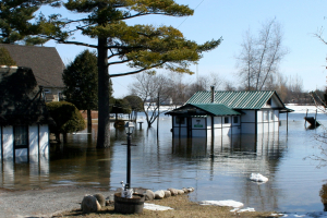
May 14, 2019 – As homeowners and municipalities look to clean up after another record flood on the Ottawa River, the need to prevent such damage from happening again and again is clear.
We don’t yet know how much the 2019 flood will cost, but we know it will be much more than prevention. Hundreds of homes were damaged, millions of sandbags were filled, residents were evacuated, public infrastructure was compromised, and military and government staff logged significant overtime. And don’t forget the incalculable loss of photo albums and family keepsakes floating in soggy basements, and the exhaustion of homeowners and volunteers fighting the rising water.
But it could have been worse. Without current regulations, more homes and businesses would have been built in the floodplain, meaning more buildings damaged and more people affected.
The good news is, prevention is possible and infinitely cheaper than recovery – all we have to do is invest in it.
Ottawa’s conservation authorities are a key part of preventing flood damage, as they’re responsible for mapping flood-prone areas, monitoring flood conditions, giving municipalities and residents advance warning, keeping infrastructure like berms, dikes and dams in good working order, and prohibiting new development in flood zones. They also require homeowners in the floodplain to floodproof their homes and septic systems when they rebuild, to prevent future damage.
They do all this on a pretty tight budget (even tighter now due to recent provincial cuts), with the support of their partner municipalities.
Conservation authorities also prevent floods by planting hundreds of thousands of trees each year and protecting critical wetlands to build natural flood resilience right into our communities. Forests and wetlands act like sponges, catching and storing runoff so it percolates slowly into waterways. Without forests and wetlands, rain and snowmelt would have nowhere to go but directly into rivers and lakes, swelling them faster and higher.
Flooding is a natural function, and it will happen more often as extreme weather intensifies. And when today’s flood waters recede and the memories of sandbag walls begin to fade, conservation authorities will need continued public and political support when we are directing development away from floodplains, requiring existing structures to be floodproofed and taking steps to protect forests and wetlands.
We need financial support from all levels of government to continue updating floodplain mapping, operating and maintaining water control structures and monitoring flood conditions. It’s also time for the three levels of government to have serious conversations about buy-out and relocation programs for homeowners in the path of floods.
Cancelling the provincial 50 Million Trees program, reducing conservation authority funding and any weakening of regulations aimed at protecting wetlands or floodplains will only lead to more flooding and millions or billions in damages down the road.
Taxpayers foot the bill when major floods damage communities. Supporting the work of conservation authorities and municipalities to protect people and property from flooding in the first place is much better bang for our buck.
By Sommer Casgrain-Robertson, General Manager, Rideau Valley Conservation Authority

May 14, 2019 — Rideau Valley Conservation Authority (RVCA), in conjunction with the Mississippi Valley Conservation Authority (MVCA) and South Nation Conservation (SNC) is maintaining the FLOOD WARNING issued on April 19, 2019 for the areas under our jurisdiction along the Ottawa River.
The most recent analysis from the Ottawa River Regulation Committee (ORRC) indicate that water levels along the lower Ottawa River from Chats Lake to the Grenville/ Hawkebury area have stabilized and will slowly recede in the coming weeks.
All flood-prone areas along the Ottawa River from Lac Coulonge down to the Montreal Archipelago are at risk as snowmelt continues along the upper Ottawa River. Levels are expected to remain high for the next two to three weeks. Risk is highly dependent on the amount of precipitation that is received. Residents are strongly urged to keep sandbags in place for now. Updates to all projections will be provided as they become available.
Residents in flood-prone areas are encouraged to closely follow evolving conditions and to take necessary measures. Residents are advised to stay away from watercourses where flows are high and where banks might be unstable. Parents are encouraged to explain dangers to children.
This FLOOD WARNING is in effect until Friday, May 17, 2019 at 5:00 PM.
RVCA and its Ottawa partners, MVCA and SNC monitor the water levels and weather forecasts with the Ministry of Natural Resources and Forestry as part of the Flood Forecasting and Warning Program. Updates are provided as conditions change.
The Ottawa River Regulation Planning Board will be reassessing forecast conditions and providing hydrological condition updates on its website daily at www.ottawariver.ca/forecast.php.
To view current flood warnings across Ontario, visit https://www.ontario.ca/law-and-safety/flood-forecasting-and-warning-program.”
- end -
"Rideau Valley Conservation Authority is a partnership of municipalities within the Rideau Valley watershed created under the Conservation Authorities Act to deliver a range of programs in watershed management and natural resource conservation."
RVCA Watershed Conditions Statements:
- Water Safety – High flows, unstable banks, melting ice or other factors that could be dangerous for recreational users such as anglers, canoeists, hikers, children, pets, etc. Flooding is not expected.
- Flood Outlook – Early notice of the potential for flooding based on weather forecasts, calling for heavy rain, snow melt, high winds or other conditions that could lead to high runoff, cause ice jams and/or lakeshore flooding or erosion.
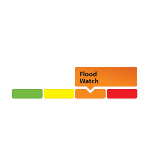
- Flood Watch – Flooding is possible in specific watercourses or municipalities. Municipalities, emergency services and individuals in flood-prone areas should prepare.
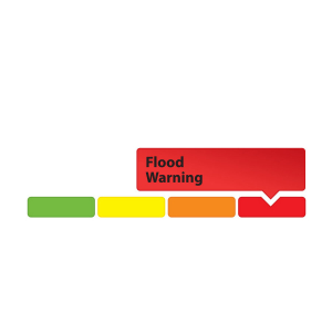
- Flood Warning – Flooding is imminent or already occurring in area watercourses.

May 14, 2019 — Rideau Valley Conservation Authority (RVCA), in conjunction with the Mississippi Valley Conservation Authority (MVCA) and South Nation Conservation (SNC) is maintaining the FLOOD WARNING issued on April 19, 2019 for the areas under our jurisdiction along the Ottawa River.
The most recent analysis from the Ottawa River Regulation Committee (ORRC) indicate that water levels along the lower Ottawa River from Chats Lake to the Grenville/ Hawkebury area have stabilized and will slowly recede in the coming weeks.
All flood-prone areas along the Ottawa River from Lac Coulonge down to the Montreal Archipelago are at risk as snowmelt continues along the upper Ottawa River. Levels are expected to remain high for the next two to three weeks. Risk is highly dependent on the amount of precipitation that is received. Residents are strongly urged to keep sandbags in place for now. Updates to all projections will be provided as they become available.
Residents in flood-prone areas are encouraged to closely follow evolving conditions and to take necessary measures. Residents are advised to stay away from watercourses where flows are high and where banks might be unstable. Parents are encouraged to explain dangers to children.
This FLOOD WARNING is in effect until Friday, May 17, 2019 at 5:00 PM.
RVCA and its Ottawa partners, MVCA and SNC monitor the water levels and weather forecasts with the Ministry of Natural Resources and Forestry as part of the Flood Forecasting and Warning Program. Updates are provided as conditions change.
The Ottawa River Regulation Planning Board will be reassessing forecast conditions and providing hydrological condition updates on its website daily at www.ottawariver.ca/forecast.php.
To view current flood warnings across Ontario, visit https://www.ontario.ca/law-and-safety/flood-forecasting-and-warning-program.”
- end -
"Rideau Valley Conservation Authority is a partnership of municipalities within the Rideau Valley watershed created under the Conservation Authorities Act to deliver a range of programs in watershed management and natural resource conservation."
RVCA Watershed Conditions Statements:
- Water Safety – High flows, unstable banks, melting ice or other factors that could be dangerous for recreational users such as anglers, canoeists, hikers, children, pets, etc. Flooding is not expected.
- Flood Outlook – Early notice of the potential for flooding based on weather forecasts, calling for heavy rain, snow melt, high winds or other conditions that could lead to high runoff, cause ice jams and/or lakeshore flooding or erosion.
- Flood Watch – Flooding is possible in specific watercourses or municipalities. Municipalities, emergency services and individuals in flood-prone areas should prepare.
- Flood Warning – Flooding is imminent or already occurring in area watercourses.
May 13, 2019 —A FLOOD WATCH is being maintained for properties around Bobs Lake and Christie Lake.
The water levels on both lakes continue to decline slowly and remain above average for this time of year. The current water level on Bobs Lake is above the ‘Full Supply’ threshold at which flood damage can occur. The current water level on Christie Lake is such that some flood damage can also occur. The current forecast indicates up to 30 mm of rain could fall between today and Wednesday. This rainfall will likely increase water levels again on Bobs Lake and Christie Lake. Parks Canada staff are closely monitoring the water levels in these lakes. Operations at the Bolingbroke Dam will take place as required to balance the levels in Bobs Lake and Christie Lake.
Water levels are now near seasonal in the rest of the Rideau Valley Watershed.
Everyone needs to be cautious around lakes and streams with the fluctuating water levels. Children need to be educated about the hazards and kept away from all watercourses.
This watershed conditions statement is in effect until Tuesday May 21, 2019 at 5 PM and will be updated at that time unless the forecast or conditions change.
-end-
More Information:
Brian Stratton, RVCA Manager Engineering Services
Rideau Valley Conservation Authority
613-692-6804, 1-800-267-3504 ext. 1141
or cell 613-799-9423
Media Enquiries:
Diane Downey, RVCA Director of Communications and Outreach
Rideau Valley Conservation Authority
613-692-3571, 1-800-267-3504 ext. 1126
or cell 613-698-9453
"Rideau Valley Conservation Authority is a partnership of municipalities within the Rideau Valley watershed created under the Conservation Authorities Act to deliver a range of programs in watershed management and natural resource conservation."
RVCA Watershed Conditions Statements:
- Water Safety – High flows, unstable banks, melting ice or other factors that could be dangerous for recreational users such as anglers, canoeists, hikers, children, pets, etc. Flooding is not expected.
- Flood Outlook – Early notice of the potential for flooding based on weather forecasts, calling for heavy rain, snow melt, high winds or other conditions that could lead to high runoff, cause ice jams and/or lakeshore flooding or erosion.
- Flood Watch – Flooding is possible in specific watercourses or municipalities. Municipalities, emergency services and individuals in flood-prone areas should prepare.
- Flood Warning – Flooding is imminent or already occurring in area watercourses.
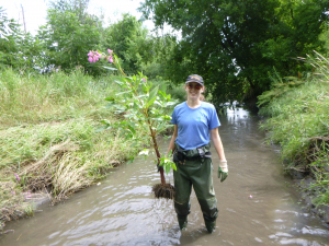
May 13, 2019 — Do you love being outside, getting your hands dirty and doing some good for the planet? Are you interested in science or biology, but want to skip the degree? We’ve got just the job for you.
The RVCA’s City Stream Watch program needs volunteer ‘citizen scientists’ to help monitor, protect and clean up the city of Ottawa’s many urban and rural streams. From invasive species removal to assisting with aquatic wildlife surveys, citizen scientists are the backbone of the program that monitors the health of urban and rural tributaries flowing into the Rideau and Ottawa rivers.
This is the best time to get involved, since a volunteer training session will be held May 25 to welcome new recruits and introduce them to the basics of stream sampling and environmental data collection.
Long-time volunteer Larry Hum encouraged residents to “give it a whirl” – especially if they’ve got an interest in biology or the environment.
“It’s an opportunity to work in bioscience without going into the heavy, heavy science,” he said.
Acting program co-ordinator Rosario Castanon-Escobar said it’s volunteers like Mr. Hum that make this program such a resounding success, year after year.
“The result of our work together is that our streams continue to be valued, respected and cared for to ensure these streams remain a point of pride within our communities,” said Castanon-Escobar.
This year’s volunteer training session is scheduled for Saturday, May 25 from 10 a.m. to noon along the shores of Sawmill Creek near Billings Bridge. All necessary equipment is provided and there is no cost to volunteers. Interested participants must pre-register for the event by contacting Castanon-Escobar at .
The 2019 program will collect data on Cranberry Creek in Kars, Hunt Club Creek in Hunt Club, Ramsey Creek in Gloucester/Mer Bleue and Borthwick Creek in Gloucester/Mer Bleue. Sampling activities will focus on assessing the habitat, water and shoreline conditions of the streams. The team will also organize several cleanups, shoreline planting events and invasive species removals throughout the season.
In the 17 years since its inception, City Stream Watch has enlisted the help of more than 3,100 volunteers, contributing more than 15,000 hours toward conservation projects and monitoring. All are welcome to participate. Results from our 2018 efforts are available online at www.rvca.ca.
The program is a community-based partnership, which includes the City of Ottawa, the Canadian Forces Fish & Game Club, the Ottawa Flyfishers Society, the Rideau Roundtable, the Ottawa Stewardship Council, National Capital Commission and Rideau Valley Conservation Authority.
For more information about the program, including the reports of streams previously studied, please visit www.rvca.ca/volunteer/city-stream-watch.
-end-

May 10, 2019 — Rideau Valley Conservation Authority (RVCA), in conjunction with the Mississippi Valley Conservation Authority (MVCA) and South Nation Conservation (SNC) is maintaining the FLOOD WARNING issued on April 19, 2019 for the areas under our jurisdiction along the Ottawa River.
The most recent analysis from the Ottawa River Regulation Committee (ORRC) indicate that water levels along the Ottawa River from Mattawa to Montreal are increasing due to recent precipitation and increased flow from the upper part of the watershed. Water levels are not expected to reach the levels observed last week over the forecasted period.
All flood-prone areas along the Ottawa River from Lac Coulonge down to the Montreal Archipelago are at risk as snowmelt continues along the upper Ottawa River. Levels are expected to remain high for the next two to three weeks. Risk is highly dependent on the amount of precipitation that is received. Residents are strongly urged to keep sandbags in place for now. Updates to all projections will be provided as they become available.
MVCA areas of concern:
Water levels in the Constance Bay area are expected to increase over the next 24 to 48 hours but are expected to be 5 to 10 cm lower than last week’s peak elevations.
RVCA areas of concern:
Water levels in the Britannia area (Grandview Road, Britannia Village, and the Belltown Community) are expected to increase over the next 24 to 48 hours but are expected to be 5 to 10 cm lower than last week’s peak elevations.
Water levels east of Cumberland Village (Boise Village, Morin Road, Leo Lane) are expected to increase over the next 24 to 48 hours but are not expected to exceed the peak levels observed last week.
SNC areas of concern:
Water level in Clarence-Rockland and Alfred-Plantagenet have risen 0.04m in the last 48 hours. Levels are expected to increase over the next 24 to 48 hours but are not expected to exceed the peak levels observed last week.
Residents in flood-prone areas are encouraged to closely follow evolving conditions and to take necessary measures. Residents are advised to stay away from watercourses where flows are high and where banks might be unstable. Parents are encouraged to explain dangers to children.
This FLOOD WARNING is in effect until Tuesday, May 14, 2019 at 5:00 PM.
RVCA and its Ottawa partners, MVCA and SNC monitor the water levels and weather forecasts with the Ministry of Natural Resources and Forestry as part of the Flood Forecasting and Warning Program. Updates are provided as conditions change.
The Ottawa River Regulation Planning Board will be reassessing forecast conditions and providing hydrological condition updates on its website daily at www.ottawariver.ca/forecast.php.
To view current flood warnings across Ontario, visit https://www.ontario.ca/law-and-safety/flood-forecasting-and-warning-program.”
- end -
"Rideau Valley Conservation Authority is a partnership of municipalities within the Rideau Valley watershed created under the Conservation Authorities Act to deliver a range of programs in watershed management and natural resource conservation."
RVCA Watershed Conditions Statements:
- Water Safety – High flows, unstable banks, melting ice or other factors that could be dangerous for recreational users such as anglers, canoeists, hikers, children, pets, etc. Flooding is not expected.
- Flood Outlook – Early notice of the potential for flooding based on weather forecasts, calling for heavy rain, snow melt, high winds or other conditions that could lead to high runoff, cause ice jams and/or lakeshore flooding or erosion.
- Flood Watch – Flooding is possible in specific watercourses or municipalities. Municipalities, emergency services and individuals in flood-prone areas should prepare.
- Flood Warning – Flooding is imminent or already occurring in area watercourses.
May 7, 2019 — Rideau Valley Conservation Authority (RVCA), in conjunction with the Mississippi Valley Conservation Authority (MVCA) and South Nation Conservation (SNC) is maintaining the FLOOD WARNING issued on April 19, 2019 for the areas under our jurisdiction along the Ottawa River.
The current weather forecast indicates that significant rainfall amounts are possible from Thursday morning into Friday as a large low-pressure system moves into the area.
The most recent analysis from the Ottawa River Regulation Committee (ORRC) indicate that water levels along the Ottawa River from Chats Lake down to Lac Deschenes are stable and may increase as a result of the forecasted rainfall but should not exceed the initial peaks observed last week. From Pointe Gatineau down to the Grenville/Hawkesbury area water levels are still decreasing but may level off as a result of the forecasted rainfall.
All flood-prone areas along the Ottawa River from Lac Coulonge down to the Montreal Archipelago are at risk as snowmelt continues along the upper Ottawa River. Levels are expected to remain high for the next two to three weeks. Risk is highly dependent on the amount of precipitation that is received. Residents are strongly urged to keep sandbags in place for now. Updates to all projections will be provided as they become available.
MVCA areas of concern:
Water levels in the Constance Bay area are stable and are expected to remain that way over the next 48 hours. The forecasted rainfall on Thursday and Friday could cause levels to increase again.
RVCA areas of concern:
Water levels in the Britannia area (Grandview Road, Britannia Village, and the Belltown Community) are stable and are expected to remain that way over the next 48 hours. The forecasted rainfall on Thursday and Friday could cause levels to increase again.
Water levels east of Cumberland Village (Boise Village, Morin Road, Leo Lane) are still decreasing but may level off due to the forecasted rainfall on Thursday and Friday.
SNC areas of concern:
Water levels in Clarence-Rockland and Alfred-Plantagenet are still decreasing but may level off due to the forecasted rainfall on Thursday and Friday.
Residents in flood-prone areas are encouraged to closely follow evolving conditions and to take necessary measures. Residents are advised to stay away from watercourses where flows are high and where banks might be unstable. Parents are encouraged to explain dangers to children.
This FLOOD WARNING is in effect until Friday, May 10, 2019 at 5:00 PM.
RVCA and its Ottawa partners, MVCA and SNC monitor the water levels and weather forecasts with the Ministry of Natural Resources and Forestry as part of the Flood Forecasting and Warning Program. Updates are provided as conditions change.
The Ottawa River Regulation Planning Board will be reassessing forecast conditions and providing hydrological condition updates on its website daily at www.ottawariver.ca/forecast.php.
To view current flood warnings across Ontario, visit https://www.ontario.ca/law-and-safety/flood-forecasting-and-warning-program”
- end -
"Rideau Valley Conservation Authority is a partnership of municipalities within the Rideau Valley watershed created under the Conservation Authorities Act to deliver a range of programs in watershed management and natural resource conservation."
RVCA Watershed Conditions Statements:
- Water Safety – High flows, unstable banks, melting ice or other factors that could be dangerous for recreational users such as anglers, canoeists, hikers, children, pets, etc. Flooding is not expected.
- Flood Outlook – Early notice of the potential for flooding based on weather forecasts, calling for heavy rain, snow melt, high winds or other conditions that could lead to high runoff, cause ice jams and/or lakeshore flooding or erosion.
- Flood Watch – Flooding is possible in specific watercourses or municipalities. Municipalities, emergency services and individuals in flood-prone areas should prepare.
- Flood Warning – Flooding is imminent or already occurring in area watercourses.

May 7 , 2019 — Rideau Valley Conservation Authority (RVCA), in conjunction with the Mississippi Valley Conservation Authority (MVCA) and South Nation Conservation (SNC) is maintaining the FLOOD WARNING issued on April 19, 2019 for the areas under our jurisdiction along the Ottawa River.
The current weather forecast indicates that significant rainfall amounts are possible from Thursday morning into Friday as a large low-pressure system moves into the area.
The most recent analysis from the Ottawa River Regulation Committee (ORRC) indicate that water levels along the Ottawa River from Chats Lake down to Lac Deschenes are stable and may increase as a result of the forecasted rainfall but should not exceed the initial peaks observed last week. From Pointe Gatineau down to the Grenville/Hawkesbury area water levels are still decreasing but may level off as a result of the forecasted rainfall.
All flood-prone areas along the Ottawa River from Lac Coulonge down to the Montreal Archipelago are at risk as snowmelt continues along the upper Ottawa River. Levels are expected to remain high for the next two to three weeks. Risk is highly dependent on the amount of precipitation that is received. Residents are strongly urged to keep sandbags in place for now. Updates to all projections will be provided as they become available.
MVCA areas of concern:
Water levels in the Constance Bay area are stable and are expected to remain that way over the next 48 hours. The forecasted rainfall on Thursday and Friday could cause levels to increase again.
RVCA areas of concern:
Water levels in the Britannia area (Grandview Road, Britannia Village, and the Belltown Community) are stable and are expected to remain that way over the next 48 hours. The forecasted rainfall on Thursday and Friday could cause levels to increase again.
Water levels east of Cumberland Village (Boise Village, Morin Road, Leo Lane) are still decreasing but may level off due to the forecasted rainfall on Thursday and Friday.
SNC areas of concern:
Water levels in Clarence-Rockland and Alfred-Plantagenet are still decreasing but may level off due to the forecasted rainfall on Thursday and Friday.
Residents in flood-prone areas are encouraged to closely follow evolving conditions and to take necessary measures. Residents are advised to stay away from watercourses where flows are high and where banks might be unstable. Parents are encouraged to explain dangers to children.
This FLOOD WARNING is in effect until Friday, May 10, 2019 at 5:00 PM.
RVCA and its Ottawa partners, MVCA and SNC monitor the water levels and weather forecasts with the Ministry of Natural Resources and Forestry as part of the Flood Forecasting and Warning Program. Updates are provided as conditions change.
The Ottawa River Regulation Planning Board will be reassessing forecast conditions and providing hydrological condition updates on its website daily at www.ottawariver.ca/forecast.php.
To view current flood warnings across Ontario, visit https://www.ontario.ca/law-and-safety/flood-forecasting-and-warning-program”
- end -
"Rideau Valley Conservation Authority is a partnership of municipalities within the Rideau Valley watershed created under the Conservation Authorities Act to deliver a range of programs in watershed management and natural resource conservation."
RVCA Watershed Conditions Statements:
- Water Safety – High flows, unstable banks, melting ice or other factors that could be dangerous for recreational users such as anglers, canoeists, hikers, children, pets, etc. Flooding is not expected.
- Flood Outlook – Early notice of the potential for flooding based on weather forecasts, calling for heavy rain, snow melt, high winds or other conditions that could lead to high runoff, cause ice jams and/or lakeshore flooding or erosion.
- Flood Watch – Flooding is possible in specific watercourses or municipalities. Municipalities, emergency services and individuals in flood-prone areas should prepare.
- Flood Warning – Flooding is imminent or already occurring in area watercourses.