

Super User
Spring Outlook
March 9, 2018 –The winter of 2017-18 has been one of wide variations and periods of record cold.
First snow on the ground to start this winter was relatively early at the beginning of November but little more fell until after December 28 followed by the onset of the record cold temperatures including -30 degrees on January 1. After ten days of frigid temperatures, a few days of warm temperatures reduced the snow cover significantly. That warm spell ended with a flash freeze. Precipitation in all its forms and widely varying temperatures continued through January into mid-February. Since February 19, maple syrup weather (above freezing during the day, freezing temperatures at night) gradually eliminated the snow cover so that, when Conservation Authority staff did the March 1 snow survey, there was no snow to measure.
As was the case this year, the snow was gone from a thaw in late February for the March 1 snow survey in 2000. Some snow fell afterward but the amount measured on March 15 was a fraction of normal. The maximum flow that year was relatively minor at 245 cubic metres per second (30 year average is 320 cms as measured at the monitoring station Rideau River at Ottawa).
Snow forecast for the next few days will restore the cover to some extent but Meteorological Service of Canada (MSC) are forecasting precipitation around normal for the rest of March. If the weather happens as forecast, a flow similar to that in 2000 can be expected which will cause minor inundation of the lowest lying areas along the Rideau system.
City of Ottawa crews began the annual ice removal program on the Rideau River between Rideau Falls and Bronson Avenue several weeks early in response to the February thaw and related increased flows. Crews will work to keep the ice from reforming until the spring freshet occurs (for more information: City of Ottawa information at 311).
Levels and flows on the Ottawa River are close to normal for the time of year. Flooding in 2017 was caused by a major weather system that produced significant rainfall over a large area in western Quebec and eastern Ontario. Such an event is not indicated in present MSC forecasts.
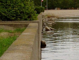
Water levels on lakes and flows in the streams are presently at or slightly above normal for the time of year as a result of the February weather. With the changing levels that can be expected over the next weeks, ice cover on lakes, ditches, local streams and rivers will continue to be unstable. Caution should be exercised by everyone when near local waterbodies. Parents should inform their children of the risks and provide appropriate supervision.
RVCA will continue to monitor conditions and will issue further statements when or if there is an indication that the situation can be expected to change significantly.
Notice of Completion — Britannia Village Flood Control Project
The Rideau Valley Conservation Authority and the City of Ottawa are pleased to announce that this project has been completed in accordance with the Class Environmental Assessment for Remedial Flood and Erosion Control Projects, approved under the Environmental Assessment Act for projects of this type. All monitoring program commitments have been met for the approved projects.
This project will protect parts of the Britannia Village community that would otherwise be affected by overbank flooding during future Ottawa River floods. Its purpose is to reduce expected property damages, public safety risks and inconveniences in this existing community during future flood events, up to and including the 1:100 year flood.
Thank you to landowners who endured disruption during construction and to the Britannia Village Community Association and the Sunset Point Homeowners’ Association for their assistance. Special thanks as well to Councillor Mark Taylor and his team for their support and participation.
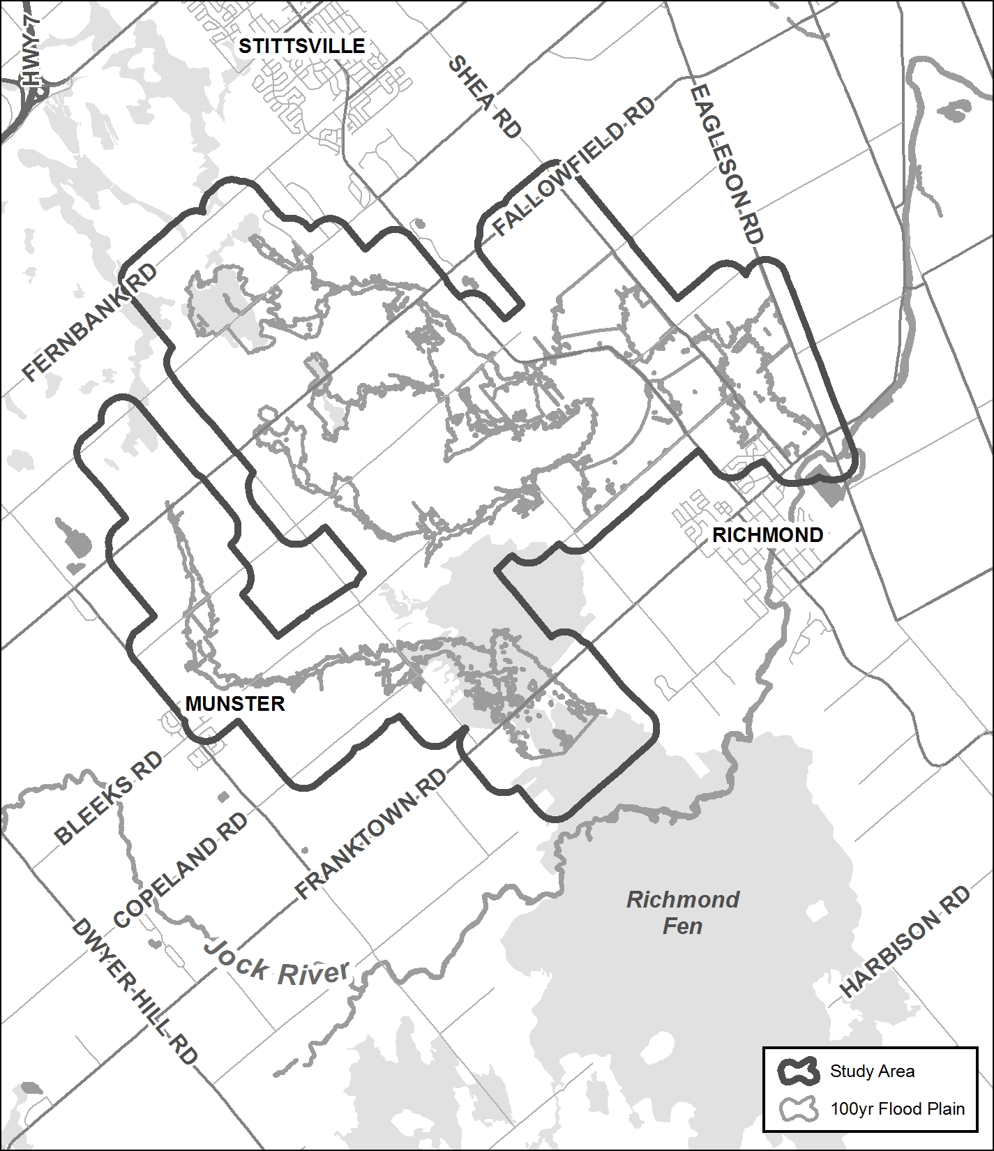
Flowing Creek and Hobbs Drain Hazard Mapping Studies
Project Status: Complete
The Rideau Valley Conservation Authority (RVCA) has completed a hazard mapping study for both the Hobbs Drain and Flowing Creek — tributaries of the Jock River.
These maps are typically known as “floodplain mapping” and they show areas that are prone to natural hazards such as flooding, erosion and natural environment features such as wetlands.
When completed, the mapping will be used by the City of Ottawa when updating their Official Plan and Zoning Schedules and in the review of development applications under the Planning Act. RVCA will also use the mapping to guide the review of development applications submitted under the Province’s Development, Interference with Wetlands and Alterations to Shorelines and Watercourses Regulation.
Members of the public are encouraged to attend our open house (date to be announced) and/or provide comments on the mapping below. Conservation Authority staff welcome historical records of past flood events, news clippings, photographs and even anecdotal stories to help confirm the reasonableness of calculations and resulting hazard mapping. For those unable to attend the open house, comments can be sent to Ferdous Ahmed, RVCA Senior Water Resources Engineer at .
These mapping studies are being completed as part of the City of Ottawa Hazard Mapping Project.
These studies are being done through a collaboration — known as the City of Ottawa Hazard Mapping Project — involving the City of Ottawa and the Mississippi Valley, Rideau Valley and South Nation Conservation Authorities. The City recognized a need to update its zoning schedules based on up-to-date flood risk mapping and has provided contributions enabling the Conservation Authorities to move ahead with these studies sooner than would otherwise be possible. The RVCA is currently working on several studies in the Ottawa area. Get more details on RVCA ongoing Flood Risk/Hazard Mapping Studies here.
Warmer Temperatures and Rain Could Cause Unsafe Conditions on Rivers and Lakes Throughout Rideau Watershed

February 16, 2018 – Significant rainfall forecast for Monday and Tuesday along with melting snow can be expected to cause river flows and lake levels to rise.
Going on iced over waterbodies is not advisable for the next several days until levels decline and colder temperatures can restore the integrity of the ice. As the snowmelt and rain runoff moves through the Rideau system, the ice cover can be expected to shift and, in some places, break up. This could lead to ice jamming at culverts and bridges which could cause localized flooding. Ponding water on the surface will make walking on the ice treacherous.
Parents should ensure that children understand the hazards of playing around watercourses in the winter and all watershed residents are advised to stay off of the ice on rivers and streams and avoid icy and snow covered streambanks where footing can be unpredictable.
Conservation Authority staff will continue to monitor conditions and issue further statements as conditions warrant.
Warmer Temperatures and Rain Could Cause Unsafe Conditions on Rivers and Lakes Throughout Rideau Watershed
February 16, 2018 – Significant rainfall forecast for Monday and Tuesday along with melting snow can be expected to cause river flows and lake levels to rise.
Going on iced over waterbodies is not advisable for the next several days until levels decline and colder temperatures can restore the integrity of the ice. As the snowmelt and rain runoff moves through the Rideau system, the ice cover can be expected to shift and, in some places, break up. This could lead to ice jamming at culverts and bridges which could cause localized flooding. Ponding water on the surface will make walking on the ice treacherous.
Parents should ensure that children understand the hazards of playing around watercourses in the winter and all watershed residents are advised to stay off of the ice on rivers and streams and avoid icy and snow covered streambanks where footing can be unpredictable.
Conservation Authority staff will continue to monitor conditions and issue further statements as conditions warrant.v
Announcement: Goulbourn Wetland Complex No Longer Exempted from RVCA's Regulated Area
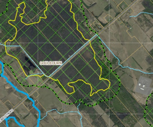
Since 2006, the Province has required Conservation Authorities to regulate development in wetlands and adjacent lands and the Rideau Valley Conservation Authority’s (RVCA) responsibilities are outlined in Ontario Regulation 174/06. At their meeting on January 25, 2018, the RVCA Board of Directors passed a motion to apply Ontario Regulation 174/06 to wetlands in the Goulbourn Wetland Complex that were identified as Provincially Significant by the Ministry of Natural Resources and Forestry (MNRF) in 2008. To-date, only wetlands identified in municipal Official Plans and zoning were regulated in this area. This recent decision by the Board brings the area in line with how wetlands are regulated in the rest of the Rideau watershed as the Goulbourn Wetland Complex had been given a special exemption. The exemption was put in place in 2009 by the RVCA’s Board of Directors at that time because of the creation of the Flewellyn Special Study Area by the City of Ottawa. The recent lifting of the exemption and the application of Ontario Regulation 174/06 as outlined above is effective immediately.
Notifying Property Owners
Notices have been sent to landowners whose property may be covered by or adjacent to wetlands identified as Provincially Significant by the MNRF in 2008. This means portions of their property may be subject to Ontario Regulation 174/06 that were previously exempt.
What Affect Does Ontario Regulation 174/06 Have?
Ontario Regulation 174/06 (Development, Interference with Wetlands and Alterations to Shorelines and Watercourses Regulation) under Section 28 of the Conservation Authorities Act, requires property owners to obtain the written permission of the RVCA prior to interfering in any way with the existing channel of a river, creek, stream or watercourse or for changing or interfering in any way (including hydrologic function) with a wetland. Therefore, property owners must receive approval from the RVCA prior to undertaking any development or site alteration within a Provincially Significant Wetland or within 120 metres of a Provincially Significant Wetland boundary. Development is defined as:
- The construction, reconstruction, erection or placing of a building or structure of any kind or changes to a building or structure that would result in an increase in size or the number of dwelling units,
- Site grading, and
- Temporary or permanent placing, dumping or removal of any material, originating on the site or elsewhere.
Why Was the Goulbourn Wetland Complex Exempted in 2009?
In 2008, the Goulbourn Wetland Complex was reevaluated and MNRF identified wetlands that were Provincially Significant. In 2009, the City of Ottawa’s Comprehensive Official Plan Amendment (OPA) which would have recognized these wetlands was appealed. The City established the Flewellyn Special Study Area as a temporary measure to work through wetland and drainage issues raised as part of the OPA appeal. In the interim, the City of Ottawa’s Official Plan indicated that no new development would be permitted in the area until the Special Study Area designation was removed. With this assurance, the RVCA’s Board of Directors decided to exempt the 2008 wetland boundaries from Ontario Regulation 174/06 while the Special Study Area was in place.
Why Has the Exemption Been Lifted?
In 2016, the Flewellyn Cumulative Effects Study was completed and the City of Ottawa presented the study’s conclusions to property owners, interested residents and the public. A new evaluation of the Goulbourn Wetland Complex was then completed and the MNRF released new Provincially Significant Wetland boundaries in 2017. Affected property owners were notified by both the MNRF and the City of Ottawa throughout the process and opportunities to challenge the boundaries were outlined. The next step is for the City to complete an OPA to adopt the new 2017 Provincially Significant Wetland boundaries.
In the fall, the City of Ottawa indicated that they were waiting until early 2018 to initiate the OPA process and would not bring an OPA to Committee until late 2018 or early 2019. This timeline gives property owners the 2018 growing season to hire a wetland evaluator to challenge wetland designations. Given this timing, a discussion was initiated with the RVCA’s Board of Directors. Any significant loss or destruction of wetlands in this area could lead to increased flooding of private property, increased flooding of municipal roads and infrastructure, impaired groundwater recharge areas, decreased baseline streamflow, impacted water quality and quantity, and damage to wildlife and aquatic habitat. The decision was made to lift the exemption and apply Ontario Regulation 174/06 to those wetlands designated as Provincially Significant in 2008 as an interim measure until the City’s OPA is complete. Once the City’s OPA process is completed, the RVCA will apply Ontario Regulation 174/06 to the final wetland boundaries adopted in the Official Plan.
For More Information Please Contact Us
We encourage you to contact our office if you have any questions or would like additional information, including a site-specific map of your property showing regulated areas.
You can contact one of our Resource Specialists at:
You can also view maps, Ontario Regulation 174/06 and RVCA’s development policies at "Regulations & Planning”Regulations & Planning”
Spring Headwaters Field Sampling
During the spring freshet we assess hundreds of headwater drainage features at various remote locations throughout the Rideau Valley watershed. We need your help conducting these assessments.
What to Expect
- You’ll spend a lot of time travelling to remote areas in an RVCA vehicle with one of our professionals. Your day will typically start at 8:00 a.m. and end at 4:00 p.m., however some days may be longer.
- You’ll be navigating steep slopes; entering cold and fast flowing water wearing hip waders; and sometimes working in inclement weather (but never in a storm).
When
- Tentative dates are March through April. Depending on the timing of the spring freshet, this opportunity may start earlier and/or end later
Skills and Competencies Required
- To be successful in this role, you will already need to be comfortable travelling long distances, working in cold temperatures in and around water, wading through streams and walking in difficult terrain. We are looking for volunteers with good communication skills, positive attitude and the ability to work in teams.
Skills and Competencies To Be Acquired
You will gain hands on experience:
- applying the Ontario Stream Assessment Protocol module to assess headwater drainage features
- wearing chest waders and working in small streams
- how to operate a multiparameter water chemistry probe
- how to measure surface water velocities
- recognizing sediment deposition
- detecting fish migration barriers
- how to identify various types of vegetation
Be Prepared
- You will need your own transportation to and from RVCA headquarters at 3889 Rideau Valley Drive in Manotick
- Read the RVCA's Participant Guide
You will need to provide:
- your own warm and water-resistant clothing (dressing in layers is a good idea);
- your own footwear and extra socks – wear closed toe shoes to get around, to wear chest waders you will require a thick pair of socks with length (no ankle socks);
- your own lunch, snacks and beverages.
We Supply
- electronic copy of the OSAP manual module: Assessing Headwater Drainage Features
- chest waders and reflective vests;
- sunscreen and DEET bug repellant;
- sampling equipment;
- supervision and instruction.
RVCA Contact
Baxter Conservation Area Day Camps
Love being outside? Enjoy working with children? Looking to complete your 40 hours of volunteering for high school? Baxter Conservation Area is looking for mature, enthusiastic volunteers to help out with our nature-themed summer day camp. Volunteers must be going into grade 9 in the fall or older. Camp includes nature hikes, pond studies, crafts, games and swimming at Baxter's sandy beach.
For more information, please contact the Baxter team at:
613-489-3592