Super User
Rain forecast for the first week of May can be expected to cause water levels to rise significantly in the Ottawa River.
Rainfall forecast for today could raise levels to what were reached last week. Additional rain forecast to fall this week can be expected to at least maintain levels and possibly cause further increases.around Lac Deschene, at Petrie Island and at Boise Village, east of Cumberland.
Within the Rideau watershed, levels will increase but no flooding issues are expected at this time with the exception of Bobs and Christie Lakes which have continued to have high levels since the freshet peak on April 7. Levels are expected to increase as a result of the rain this week.
With water levels increasing again, residents need to be aware of the associated dangers. Children need to be kept away from ditches, streams, lakes and rivers.
Conservation Authority staff will continue to monitor conditions and will issue updates as warranted.
For water level and flow information in the Rideau system as well as the Ottawa River, visit the RVCA Streamflows and Water Levels webpage.
For more information about conditions on the Ottawa River, also check the webpage of the Ottawa River Regulation Planning Board.
RVCA Watershed Conditions Statements:
- Water Safety – High flows, unstable banks, melting ice or other factors that could be dangerous for recreational users such as anglers, canoeists, hikers, children, pets, etc. Flooding is not expected.
- Flood Outlook – Early notice of the potential for flooding based on weather forecasts, calling for heavy rain, snow melt, high winds or other conditions that could lead to high runoff, cause ice jams and/or lakeshore flooding or erosion.
- Flood Watch – Flooding is possible in specific watercourses or municipalities. Municipalities, emergency services and individuals in flood prone areas should prepare.
- Flood Warning – Flooding is imminent or already occurring in area watercourses.
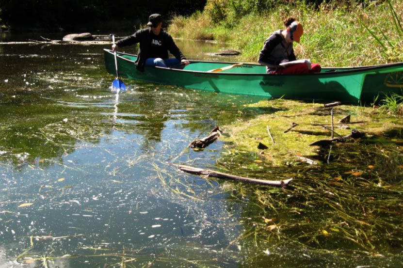
Hearts Desire Riparian Restoration Plan
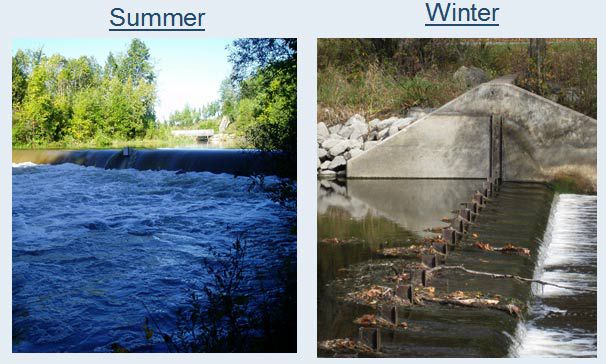
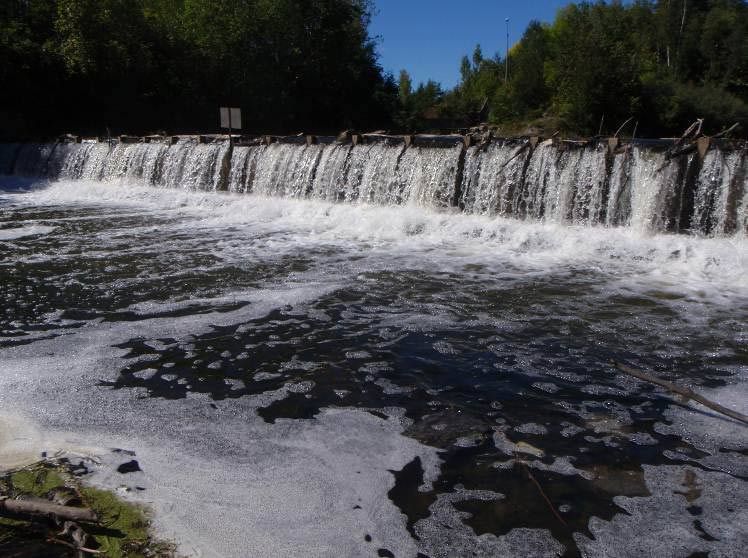
The Hearts Desire Weir is a low-head inline structure operated seasonally on the Jock River between two communities, Hearts Desire and Stonebridge. The Jock River is a tributary river to the Rideau River located about 900 m downstream of the weir. The weir was constructed in 1975 to: provide higher summer flows and thereby improve habitat conditions for fish and wildlife; ensure adequate water for livestock watering; provide community ponds for fire protection and community beautification; and improve the year-round appearance of the river and lessen the likelihood of future pollution problems resulting from expanding urbanization.
Over the last 42 years, a great deal about the watercourse and its neighbouring communities has changed, including:
- concepts on how rivers and watersheds are managed,
- occupational health and safety risks associated with the annual installation and removal of the weir,
- concerns from local community groups about slope failures and erosion upstream of the weir; and,
- indications from whitewater enthusiasts that the weir site is considered to be hazardous by canoeists and kayakers.
In February 2008, the RVCA Board of Directors approved the development of a plan to decommission the Hearts Desire Weir. In response to public input, a restoration plan for the Jock River and its riverbank was also initiated. The decommissioning plan and restoration plan is now in draft form and ready for public input.
The RVCA is committed to maintaining the current operation of the weir until such a time that the Board of Directors chooses an alternative.
For more information, contact Terry Davidson at or 613-692-3571 ext. 1107 or Mike Yee at or ext. 1176.
Resources
Shoreline Property Owner Package, November 2013
- Hearts Desire Weir Decommissioning and Riparian Restoration Plan Protocol
- Landowner Contact — Shoreline Site Visits
- Landowner Contact Surveying of Estimated Water Levels
Hearts Desire Riparian Restoration Concept Report, October 2011
hd-Riparian_Restoration_PlanFINAL.pdf
Appendix I: Community Representatives Meeting Minutes - September 2010 and Open House Meeting Notes - December 2010
Parish Geomorphic Hydraulic Modeling Technical Report, July 2011(11 mb)
J.L. Richards and Associates Ltd. Jock River Conservation Study, June 1968
High Waters in Lower Parts of Ottawa River Watershed
The rise of flood waters on the Ottawa River is slow but continuing and is approaching the 1:10 year flood frequency*.
The slow rise of flood waters on the Ottawa River will continue today aided by runoff from the overnight rains. Levels had dropped yesterday on Lac Deschene but have risen again today. Downstream of Chaudiere Falls the rate of rise decreased slightly but that is likely to change with the impact of the rain.
The locations at risk of flooding on the Ottawa River within the jurisdiction of the Rideau Valley Conservation Authority are communities around Lac Deschene (e.g. Grandview Avenue and Britannia) and Boise Village east of Cumberland. There is an estimated 45 centimetres of water at the intersection of Morin Road and Ruelle Dubois in Boise Village that will limit access to homes in the neighbourhood. No reports of flooding have been received so far on properties on Lac Deschene.
On the Rideau system, Bobs and Christie Lakes remain high with some property flooding. With minimal rain in the 7 day forecasts, these lake levels can be expected to begin declining.
Levels on the Ottawa River can also be expected to decline but how quickly depends on what flows are received from further north in the watershed as the spring melt advances. Normally there is a lag between the high flows from the southerly tributaries and that from the upper parts of the watershed.
Spring water safety needs to be observed by all. In particular, children need to be warned of the dangers of cold and fast flowing waters
Conservation Authority staff will continue to monitor conditions and will issue an update on Monday, April 24.
For water level and flow information in the Rideau system as well as the Ottawa River, visit the RVCA Streamflows and Water Levels webpage.
For more information about conditions on the Ottawa River, also check the webpage of the Ottawa River Regulation Planning Board.
*1:10 year frequency is the flood level that has a likelihood of occurring of 10% in any given year.
RVCA Watershed Conditions Statements:
- Water Safety – High flows, unstable banks, melting ice or other factors that could be dangerous for recreational users such as anglers, canoeists, hikers, children, pets, etc. Flooding is not expected.
- Flood Outlook – Early notice of the potential for flooding based on weather forecasts, calling for heavy rain, snow melt, high winds or other conditions that could lead to high runoff, cause ice jams and/or lakeshore flooding or erosion.
- Flood Watch – Flooding is possible in specific watercourses or municipalities. Municipalities, emergency services and individuals in flood prone areas should prepare.
- Flood Warning – Flooding is imminent or already occurring in area watercourses.
"Minor" Drought Status Rescinded
The drought status in the Rideau River watershed that was left at “Minor” after a dry year in 2016 is, by this statement, reduced to “Normal”.
The uncertainty that prompted holding the Minor status through the winter was because it wasn’t clear what state groundwater resources had been left at as the onset of winter arrived. With a period of warmer temperatures and the loss of much of the snow cover by late March, there was an opportunity to access the monitoring wells in the Rideau River watershed. Measurements indicated that groundwater levels had been restored to about the long term average.
By this time in mid-April last year, farmers were able to get on their fields to start ploughing and planting. This year, flooding is still a concern and precipitation since the start of the year is 5% above normal. Dry conditions can at any time return, of course, and RVCA staff will continue to monitor conditions and issue statements as warranted.
All watershed residents are encouraged to conserve water at all times not just when drought conditions prevail.
Relevant information sources are as follows:
- Ministry of Environment and Climate Change
- Ontario’s Low Water Response program
- Hourly and daily streamflows and water levels
In order that we can track impacts of the drought conditions in the watershed, we request that any individuals or businesses in the Rideau Watershed who may be experiencing difficulties with their wells please contact the Conservation Authority by calling 613-692-3571 or 1-800-267-3504, ext. 1128 or by email (instructions at http://www.rvca.ca/low_water/index.html ). There is also the Drought Impacts Map application on the RVCA website under Watershed Conditions.
RVCA Watershed Conditions Statements:
- Water Safety – High flows, unstable banks, melting ice or other factors that could be dangerous for recreational users such as anglers, canoeists, hikers, children, pets, etc. Flooding is not expected.
- Flood Outlook – Early notice of the potential for flooding based on weather forecasts, calling for heavy rain, snow melt, high winds or other conditions that could lead to high runoff, cause ice jams and/or lakeshore flooding or erosion.
- Flood Watch – Flooding is possible in specific watercourses or municipalities. Municipalities, emergency services and individuals in flood prone areas should prepare.
- Flood Warning – Flooding is imminent or already occurring in area watercourses.
Flood Watch to Include Ottawa River
As water levels and flows in the Rideau River watershed recede, levels on the Ottawa River have been rising.
Rain on Saturday and Sunday had little impact on stream flows anywhere in the Rideau watershed. Rain forecast for Wednesday and Thursday of about 30 millimetres can be expected to cause flows to rise by as much as 50 cubic metres per second on the Rideau. This will not be enough to bring on the return of flooding in those areas recently affected. Levels on three of the four Rideau Canal reservoir lakes have been declining very slowly but are sensitive to further rain presently being slightly below the Full Supply level. Bobs Lake has remained slightly above the Full Supply level because outflow has to be controlled to limit the impact downstream on Christie Lake. If the rain forecast does materialize, reservoir lake levels can be expected to rise slightly again.
The Ottawa River has been rising slowly over the last week as the many tributaries contribute their spring flows. There will be inflows passing through for several days as seasonal weather brings runoff from further north. The locations at risk of flooding on the Ottawa River within the jurisdiction of the Rideau Valley Conservation Authority are communities around Lac Deschene (e.g. Grandview Avenue and Britannia) and Boise Village east of Cumberland. There is already water on roads (Morin Road, Leo Lane) in Boise Village that can be expected to rise and limit access.
It continues to be risky to be around waterbodies. The water is still relatively high, fast moving and cold. Parents need to remind their children about the dangers.
Conservation Authority staff will continue to monitor conditions and will issue an update on Friday, April 21.
For water level and flow information in the Rideau system as well as the Ottawa River, visit the RVCA Streamflows and Water Levels webpage at http://his.rvca.ca/rvcafwl/ .
For more information about conditions on the Ottawa River, also check the webpage of the Ottawa River Regulation Planning Board at http://ottawariver.ca/river-levels-flows.php#river-levels-flows-7-days .
RVCA Watershed Conditions Statements:
- Water Safety – High flows, unstable banks, melting ice or other factors that could be dangerous for recreational users such as anglers, canoeists, hikers, children, pets, etc. Flooding is not expected.
- Flood Outlook – Early notice of the potential for flooding based on weather forecasts, calling for heavy rain, snow melt, high winds or other conditions that could lead to high runoff, cause ice jams and/or lakeshore flooding or erosion.
- Flood Watch – Flooding is possible in specific watercourses or municipalities. Municipalities, emergency services and individuals in flood prone areas should prepare.
- Flood Warning – Flooding is imminent or already occurring in area watercourses.
Flood Warning Downgraded to Flood Watch
With access ways to the waterfront properties on the Long Reach of the Rideau River (Kars to Burritts Rapids) again passable, the Flood Warning, in place for the last week, is now reduced to Flood Watch.
Rain forecast for Saturday evening into Sunday is expected to cause an upturn in flows in the Rideau system. However, flows are expected to have receded sufficiently by then that the increase will have a minor impact. The expectation is that flows, as measured at the recording station at Carleton University, will increase to about 280 cubic metres per second (cms) by early Monday. This is well below the peak flow reached on April 8 (456 cms) and below flows that would cause flooding to happen again.
The Rideau Canal reservoir lakes are all at their full supply level and measures are being taken to bring those levels down within the normal operating ranges for each of the four lakes. However, releases from each of the lakes has to be done to minimize the impacts downstream. Wolfe Lake has to be brought down in concert with Upper Rideau Lake and, in turn, Upper Rideau levels have to be managed within the limits of Big Rideau and Newboro Lakes. Releases from Bobs Lake have to be done with regard for levels on Christie Lake, flows in Perth and flows into Big Rideau and outflow from Big Rideau Lake has to be done with regard for levels on the Long Reach.
While flows are declining and temperatures are warming, it is still risky to be around waterbodies. The water is still relatively high, fast moving and cold so parents need to educate their children about the dangers
The Flood Watch will remain in effect through the weekend. Conservation Authority staff will continue to monitor conditions and will issue updates as warranted.
RVCA Watershed Conditions Statements:
- Water Safety – High flows, unstable banks, melting ice or other factors that could be dangerous for recreational users such as anglers, canoeists, hikers, children, pets, etc. Flooding is not expected.
- Flood Outlook – Early notice of the potential for flooding based on weather forecasts, calling for heavy rain, snow melt, high winds or other conditions that could lead to high runoff, cause ice jams and/or lakeshore flooding or erosion.
- Flood Watch – Flooding is possible in specific watercourses or municipalities. Municipalities, emergency services and individuals in flood prone areas should prepare.
- Flood Warning – Flooding is imminent or already occurring in area watercourses.