

Super User
July 29, 2019 – Custom-built smartphone apps are changing the way staff at Rideau Valley Conservation Authority get their work done – and saving time, money and headaches in the process.
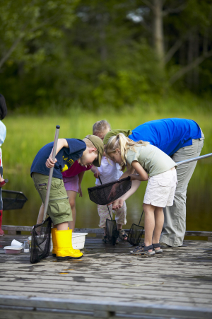
This spring, the RVCA launched its latest app, this one for classifying shorelines – something no other conservation group is doing digitally.
Gone are the bulky clipboards and windswept papers of previous surveys. And vanquished are the days of tedious data entry after a long season on the water.
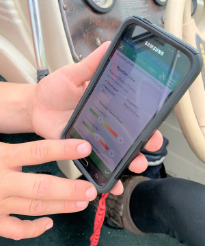
These days, with the tap of an app staff can quickly analyze a shoreline, take a photo and input all the relevant data into a digital database, all from the palm of their hand – and from the middle of a river.
"It's amazing," said Adrienne Lewis, an aquatic resource technician with RVCA for the past 11 years. "It's fast and easy. We don't even have to label our photos, because we take them inside the app. We've eliminated 40 to 60 pieces of paper each day."
In-house GIS/database specialist Chris Czerwinski took the survey's old paper field form and turned it into a custom-made digital data chart using the platform Survey123.
This summer, as Adrienne heads down the river with a student by her side, she assesses shoreline conditions from her smartphone, ticking boxes in the app to make note of erosion, invasive species, vegetation and other factors that contribute to water quality and shoreline health.
The data is uploaded to the cloud, offering real-time results from the field and eliminating the need for manual data entry – and reducing the opportunity for human errors by half. The data is then easily formatted to inform RVCA programs and decisions.
It's a huge time savings.
"We've taken the workflow from the field and emulated that in the app," Chris said. "This survey project was supposed to take two years and they're going to finish it in one season. That speaks to the efficiency of the new process."
The RVCA has come a long way in a short time when it comes to tech.
"I built the RVCA's first app in 2013, and it was fairly novel at the time," Chris said.
But by today's standards, that first app is downright quaint: it ran on a GPS-equipped handheld device that could run a Windows operating system that's no longer even supported.
Since then, the RVCA has developed five different mobile apps to improve workflow in the field, assisting staff with water quality monitoring, aquatic insects sampling, shoreline classification, septic re-inspection, and forestry site visits.
"Ten years ago, everything was done on paper," Chris said. "Now, the amount of technology we use is amazing. It has exponentially driven workflows up."
The demand for mobile app solutions is so great, he's having to manage staff expectations: there's only so much that can be developed at once.
"Staff always want more, because they can see the benefits," he said. "There's so much more to come."
Collaboration is key
Conservation authorities across the province are all taking up the tech trend, developing apps for all manner of monitoring and tracking programs they run every day to promote healthy watersheds.
And with tight budgets and stretched staff, sharing has been caring. A key benefit of the new technology is the ability to share workflows with other conservation authorities and environmental groups. Chris shares what he creates and borrows from others. This saves time and effort for all the groups, because no one's reinventing the wheel.
This winter, for example, Chris will borrow the bones of a snowpack measuring app developed by Quinte Conservation and tweak it to suit the RVCA's needs – no need to create his own.
It's especially easy to collaborate when the apps are for monitoring programs that follow international, national or provincial data collection protocols. If everyone's following the same process with the same data criteria, a customized app can be used by any protocol partner, Chris said.
And the potential for new apps and digital solutions is endless.
"When I think where we'll be in five years, it's incredible," Chris said.
-end-
Mud Creek Flood Risk Mapping Study, July 2019
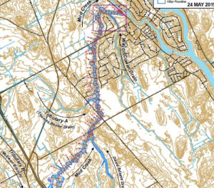
Mud Creek Hazard Mapping Study
Project Status: Complete
The Rideau Valley Conservation Authority (RVCA) has completed a hazard mapping study for Mud Creek from 3rd Line Road North to the Rideau River.
These maps have been traditionally known as “floodplain mapping” or “regulation mapping” and they show areas that are prone to natural hazards such as flooding, erosion and natural environment features such as wetlands.
When completed, the mapping will be used by the City of Ottawa when updating their Official Plan and Zoning Schedules and in the review of development applications under the Planning Act. RVCA will also use the mapping to guide the review of development applications submitted under the Development, Interference with Wetlands and Alterations to Shorelines and Watercourses Regulation.
Members of the public are encouraged to attend the upcoming open house (details below) and/or provide comments on the draft mapping (see below). Conservation Authority staff welcome historical records of past flood events, slope failure, erosion, news clippings, photographs and even anecdotal stories to help confirm the reasonableness of calculations and resulting hazard mapping For those unable to attend the open house, comments can be sent to Ferdous Ahmed, RVCA Senior Water Resources Engineer at .
These mapping studies are being completed as part of the City of Ottawa Hazard Mapping Project.
Mud Creek Report
Report: Mud Creek Flood Risk Mapping from Prince of Wales Drive to Rideau River, July 9, 2019
These studies are being done through a collaboration — known as the City of Ottawa Hazard Mapping Project — involving the City of Ottawa and the Mississippi Valley, Rideau Valley and South Nation Conservation Authorities. The City recognized a need to update its zoning schedules based on up-to-date flood risk mapping and has provided contributions enabling the Conservation Authorities to move ahead with these studies sooner than would otherwise be possible. The RVCA is currently working on several studies in the Ottawa area.
Stay safe this summer: stay on the trails!
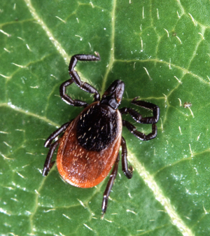
July 19, 2019 – It’s a great time to be outdoors, but be aware: certain pests and poisonous plants are getting in on the action, too.
As you hit the trails, remember to stay on the path and dress appropriately to protect against ticks, poison ivy, wild parsnip and other hazards.
Ticks:
Black-legged ticks are on the rise in Eastern Ontario and can carry Lyme disease, which is passed to humans through tick bites. Left untreated, Lyme can cause chronic neurological and physical problems including memory loss, mobility issues and heart conditions.
But don’t let that keep you inside! Reasonable precautions should prevent most tick bites. When you’re in the woods, stay on the path, wear long pants and sleeves, tuck your pants into your socks and use bug spray with DEET or picaridin. A quick sweep of your clothes with a sticky lint roller before you go home will help catch errant ticks. When you get home, do a thorough tick check of your entire body, including in your armpits, groin area, behind your ears and along hairlines.
If you do find a tick attached, remove it as soon as possible. Contact your doctor if the tick looks engorged or you think has been attached for a long time, to see if you need antibiotics.
If the tick was attached for less than 24 hours and its body does not appear swollen from feeding, you should still be on the lookout for signs and symptoms of Lyme disease for the next 32 days. If you do develop symptoms, see a doctor.
Poisonous plants:
Poison ivy, wild parsnip and giant hogweed all have a presence in Eastern Ontario, lining roadside ditches, taking over empty fields and popping up along nature trails and woodlots.
Touching these plants or their sap can result in painful skin rashes and burns, particularly wild parsnip, which is sun-activated and can cause severe burns and even blindness in extreme cases.
Wear long pants and sleeves, close-toed shoes and socks. The sap from these plants can contaminate your clothes, so be careful when undressing and handling your clothes after an outing.
If you do come in contact with the plants, wash the area with soapy water and stay out of the sun. If the sap gets in your eyes, wash immediately and contact a doctor.
Of course, it’s important to know what to look for so you can avoid these issues altogether.
Poison ivy is perhaps the best known of the three plants. It can grow between 10 and 80 centimetres high, and its leaves range from 8 to 55 millimetres long. Poison ivy leaves feature three pointed leaflets – usually toothed – with the middle leaf being much longer. The leaves are reddish in the spring, turn green in the summer, and become various shades of yellow, orange, or red in the fall. The plant produces clusters of cream to yellow-green flowers.
Wild parsnip can grow up to 1.5 metres tall, with a thick, smooth stem topped with green-yellow flowers forming clusters up to 20 centimetres across.
Giant hogweed looks similar to wild parsnip but grows up to five metres tall in some cases. Its white flowers are clustered in groups between 30 and 90 centimetres across, and its thick stem often features prominent purple blotches.
Remember: There’s so much to see and do in the Rideau Valley watershed – don’t let these spoilsports get in your way! Take precautions, stay on the path and, most importantly, have fun.
-end-
We’ve got the relaxing beaches you’ve been dreaming of
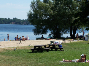
June 24, 2019 – Ah, summer: a time for relaxing with friends, soaking up the sun and, of course, hitting the beach.
But sometimes beach days are more hassle than relaxle: fighting traffic, circling for parking and dodging rogue frisbees while you defend your tiny square of sand from the hordes of other beachgoers. Some fun!
But there’s a solution: instead of wasting 30 minutes parking, spend it heading to Baxter Conservation Area in Osgoode, Rideau Ferry Yacht Club Conservation Area near Smiths Falls or Foley Mountain Conservation Area in Westport for a beautiful beach day away from the crowds.
Just 20 minutes from urban Ottawa, Baxter offers one of the cleanest, prettiest beaches along the Rideau River, complete with ample picnic tables, barbeque pits and green space to settle in for the day.
When you’re tired of toasting your toes in the sun, you can stretch your legs along five kilometres of easy walking trails and boardwalks through sun-dappled forests, meadows and wetlands. And kids (or kids at heart) can scan the buzzing Baxter Pond for leopard frogs, minnows and other curious creatures, too.
Rideau Ferry wins our Best Beach award: the beautiful, clean swimming area on Lower Rideau Lake is hardly ever crowded, and is less than an hour from urban Ottawa. Make a day of it and enjoy the many picnic tables and grill pits.
Foley Mountain’s beach is also well worth the drive to Westport considering the property includes 11 kilometres of trails and a stunning view of the region from the famous Spy Rock. Work up a sweat before diving into the refreshing waters of Upper Rideau Lake!
Honestly, with all these fun activities, you may never want to leave (but please do, because the parks close at dusk).
And on top of all that, it’s great bang for your buck: parking is only $7 for the day or $50 for an annual pass, valid at all of our paid parking lots across the watershed.
For all the details and directions, visit rvca.ca/conservation-areas.
See you on the sand!
-end-
June 21, 2019 – Twelve classes of low-income students will experience the natural world first hand – some for the very first time – thanks to a generous grant from the Ottawa Community Foundation.
The Rideau Valley Conservation Foundation is campaigning to help 50 disadvantaged classes access its outdoor education programs during the 2019/2020 school year. The grant of $9,420 from the Ottawa Community Foundation will cover tuition and transportation costs for 12 schools from the city of Ottawa.
Each year, the Rideau Valley Conservation Authority welcomes more than 10,000 elementary and secondary school students to its Outdoor Education programs at Baxter and Foley Mountain conservation areas. The curriculum-based sessions taught by certified teachers give students hands-on experiences in nature while they learn about natural science, our role in the natural world and how we can protect it.
But not all students can afford the same experiences as their peers; there are at least 37 priority schools in the Rideau Valley region where funding simply isn’t available for “extras” like outdoor education. Unfortunately, it’s these students who are often missing natural experiences the most: many of them are new to Canada or live in urban communities where walking among the trees, exploring a wetland or catching frogs is completely unknown to them. That’s where the Foundation and its generous donors come in.
There is a growing body of evidence that learning through outdoor active play has positive effects on a child's physical, emotional, and intellectual health. More and more, children suffer from “nature deficit disorder” – a lack of connection with the natural world.
Staff use the Ministry of Education’s list of priority schools – determined based on national census income data – and work with local school boards directly to identify schools that would benefit from financial support to get their students outside and into nature.
For more information about the RVCA’s educational programs, visit https://www.rvca.ca/outdoor-education.
To support the Foundation’s conservation efforts, visit https://www.rvcf.ca/.
-end-
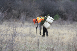
June 19, 2019 – Our hardworking forestry team has wrapped up another successful tree planting season, and they’re already looking ahead to next year.
The Rideau Valley Conservation Authority (RVCA) is now booking site visits with landowners wishing to reforest their retired farm fields or otherwise empty and idle lands.
The low-cost, full-service program includes free site visits, custom planting plans, site preparation, tree planting, follow-up assessments and maintenance to give the seedlings the best chance of survival. All of this is available for only $0.15 per tree, or $120 an acre!
“Increasing forest cover is critical to watershed health, but so much of the land is privately owned,” said forestry program manager Scott Danford. “This program offers landowners easy and affordable tree planting services while helping us meet our larger watershed management goals.”
This year Danford’s team planted about 200,000 trees across the region. The RVCA has planted 6.4 million trees since 1984 and aims to hit 6.5 million in 2020.
“The RVCA staff have been a pleasure to work with since we started in 2014,” said Maberly landowner Peter Ginsberg. “I'm very happy with this program that made it possible for us to help support the planting of almost 12,000 trees on our property.”
The forestry team is booking site visits this summer to plan for the 2020 spring planting season. The planting area must be at least one acre in size, suitable for tree planting and the landowner must be willing to plant 1,000 trees or more.
Typical costs are $0.15/tree ($120/acre). The RVCA and its planting partners cover all other costs.
“We have several community-minded partners who support our tree planting program,” said Danford.
Planting partners include the City of Ottawa’s Green Acres program and Forests Ontario, Mississippi Valley Conservation Authority, Eastern Ontario Model Forest, Pratt & Whitney Canada, McGarry Funeral Homes, Stingray LiVE 88.5, Carleton Refrigeration, Pratt & Whitney Canada and the Rideau Valley Conservation Foundation also contribute to the forestry program to keep costs low for landowners.
Tree planting is one of the most practical ways to take care of our watershed and the wider environment. RVCA’s reforestation programs are a great way for landowners to improve their property by:
- Protecting soil from erosion
- Improving water quality
- Reducing the risk of flooding
- Carbon sequestration
- Improving wildlife habitat
- Increasing biodiversity
- Water conservation and so much more!
If you want to plant trees, book a site visit or to get more information, call Scott Danford at 613-692-3571 or 1-800-267-3504 ext. 1175 or email .
-end-
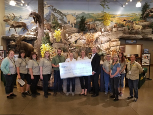
June 14, 2019 - Everyone wants a nice, quiet spot where they can get away from it all, without driving hundreds of kilometres into the woods. That will become a reality this summer at Chapman Mills Conservation Area with the installation of a new, accessible public dock.
Thanks to a generous donation to the Rideau Valley Conservation Foundation (RVCF) from Cabela’s Canada Outdoor Fund, the installation will replace the conservation area’s old dock in a more accessible location, creating a better place to catch a fish, launch a canoe or just dip your toes in the mighty Rideau River.
The Rideau Valley Conservation Authority (RVCA) owns and manages the conservation area off Winding Way and Prince of Wales drives. Conservation Lands technician Megan Dunster said the property’s current dock and water access set-up is damaging the fragile shoreline as anglers and paddlers find more convenient ways into the water.
The new dock will protect the shoreline and intends to meet accessibility standards for slope and width.
Dunster said there’s a shortage of public fishing spots in the city of Ottawa, particularly along the Rideau River. The new dock will allow the thousands of families who live in south Ottawa to take part in the sport – some for the very first time.
“I firmly believe the more that people can experience the outdoors, the more they will care about maintaining a healthy environment for themselves and for future generations,” said Dunster. “This connection is essential to the RVCA’s goals for a healthy, sustainable watershed.”
The dock project will include interpretive signs about fishing in the Rideau River.
Cabela’s Canada Outdoor Fund provided more than $4,800 for the project through a partnership with the RVCF, a registered charity which supports the RVCA’s conservation and watershed management goals.
For more information or to support the foundation, visit www.rvcf.ca.
-end-
Shoreline program now booking to protect against floods
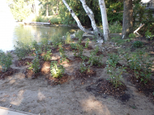
June 10, 2019 – Planting trees and shrubs along your shoreline can protect your property from flood damage – and the Rideau Valley Conservation Authority is now booking site visits to help get the job done.
The RVCA’s Shoreline Naturalization Program offers landowners low-cost technical guidance, project management and all the native trees and shrubs you need to build a robust natural buffer along your waterfront.
These strategically-placed plants have hearty roots that hold soil in place so it doesn’t wash away during periods of high water, or in high-wake areas. There’s no need for expensive rock “rip rap” or other high-tech engineering – Mother Nature already knows what to do.
A three-metre natural buffer also discourages geese, reduces runoff and provides crucial wildlife habitat.
This spring, RVCA staff installed a total of 11,500 native plants on 63 private properties across the watershed. They also worked with a number of community groups to naturalize public shorelines.
Staff are now booking site visits for the 2020 spring planting season, and this year waterfront residents in the Tay Valley subwatershed can participate completely free of charge.
How does it work?
RVCA staff will visit your property between June and October to discuss your vision and assess planting potential. Then they’ll develop a unique plan for your property, including recommendations for the best native species for your property’s growing conditions. They’ll also discuss how you’d like to maintain your water access, seating areas and view.
From there, you can choose which subsidized plants you’d like based on your custom planting plan and the RVCA’s available species list, and staff will order them for you. In spring 2020, staff will deliver your plants and, if you choose, even do the planting for you!
Why naturalize?
Ninety per cent of all river life depends on a healthy shoreline to survive. But this “ribbon of life” also plays a crucial role in filtering out pollutants, reducing erosion and easing flood risks. By adding a natural buffer between your home and the water, you are protecting the health of our drinking water, ecosystems and shores.
For more information, visit https://www.rvca.ca/stewardship-grants/shoreline-naturalization/shoreline-naturalization-program. To book a site visit contact Meaghan McDonald.
-end-