RVCA (1141)
Children categories

Department (66)
Main Office Phone Numbers : 613-692-3571 / 1-800-267-3504
Staff Directory
Eastern Ontario Mayors Support CA Concerns About Housing Bill 23
Bill 23: Less Protection, More Cost, Diminished Local Decision-Making
If your application has been refused or approved with conditions, you can appeal through a the RVCA's Hearing Board.
For guidance, downoad the RVCA Hearing Procedures.
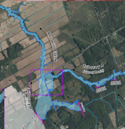
Mosquito Creek Flood Risk Mapping from Mitch Owens Road to Rideau River
Upper Jock River Flood Risk Mapping Study from Richmond Road to Ashton Station Road, July 2021
New StoryMap takes deep dive into region's vulnerable drinking water
Local Conservation Authorities expand septic approval services
Part of Chapman Mills trail to close for bridge replacement
Seeking new Chair for Mississippi-Rideau Source Protection Committee
More...
Fall in love with Fall at Foley Mountain
Van Gaal Drain Hazard Land and Regulations Mapping Update - Public Consultation and Open House
Project Status: Active
Posted: September 12, 2022 The Rideau Valley Conservation Authority, in collaboration with the City of Ottawa, has recently embarked on a hazard mapping update for the realigned Van Gaal Drain in the Village of Richmond. This mapping identifies changes to flood prone areas and where new development is to be allowed, restricted or prohibited in accordance with provincial and municipal planning policies.
These maps have been traditionally known as “floodplain mapping” or “regulation mapping” and they show areas that are prone to natural hazards such as flooding, erosion and natural environment features such as wetlands.
Mapping and regulating natural hazard areas ensure safe and sustainable development. Development projects within these areas must obtain permission from the Conservation Authority before proceeding (Ontario Regulation 174/06, Development, Interference with Wetlands and Alteration to Shorelines and Watercourses). When completed, the mapping will also be used by the City of Ottawa when updating their Official Plan and Zoning Schedules and in the review of development applications under the Planning Act.
The Rideau Valley Conservation Authority (RVCA) invites you to participate in the public consultation process regarding this mapping update from September 12 to October 14, 2022.
You can participate by viewing draft maps online (see links below) and by contacting an RVCA Resource Specialist (phone 613-692-3571, toll-free at 1-800-267-3504 ext. 1132 or 1193, email . You can also join us at our public open house.
Van Gaal Drain Hazard Land and Regulations Mapping Open House
Richmond Memorial Community Centre (Seniors’ Room)
6095 Perth Street, Richmond
Wednesday, October 5, 2022
4:30 to 8 p.m.
This consultation period and open house offer the opportunity for RVCA staff to respond to any questions that you may have regarding the mapping and collect your input about local conditions.
Draft Map
Interactive Map - Click here to view the interactive map full screen
The interactive map allows you to zoom in to a specific property and get very specific digital informaiton. Need help? Have questions? Call a Resource Specialist at 613-692-3571 or 1-800-267-3504 ext. 1132 or 1193 or email us at .
Need help? Have questions? Call a Resource Specialist at 613-692-3571 or 1-800-267-3504 ext. 1132 or 1193 or email us at .
Technical Report
Download J.F. Sabourin and Associates Inc. report:
Richmond Village Development / Proposed Realignment of Van Gaal Drain
 Your Eastern Ontario conservation authorities were thrilled to be back at the Plowing Match to showcase the many ways we help communities protect their natural resources while steering clear of natural hazards. On this page you’ll find links to your local conservation authority, which will take you to information about stewardship grants, planning and regulations, conservation areas and more. Below, you’ll also find some key digital resources to help you implement best practices on your own property.
Not from Eastern Ontario? Click here to search with your postal code.


